

.
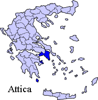
Periphery: Attica
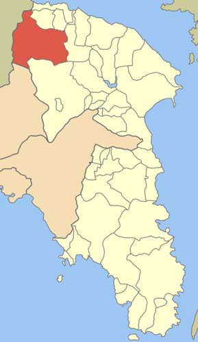
Prefecture : East Attica
| Avlona Δήμος Αυλώνας Dimos Avlonas |
|
| Statistics | |
|---|---|
| Prefecture and Periphery (Region): | Attica |
| Metropolitan Area: | Athens |
| Location: Latitude: Longitude: |
38.268(38°16'1")N 23.698 (23°41'52")E |
| Population: (2001) |
5056 |
| Elevation: -lowest: -centre: |
about 20 m 120 m (centre) Parnitha (1,413 m) |
| Postal code: | 190 11 |
| Area/distance code: | 11-(00)30-22950 |
| Municipal code: | 0307 |
| Car designation: | Y (prev.)ZB-ZY pres. |
Avlona (Greek: Αυλώνα), Latin and older form: Aulon is a municipality of East Attica in Greece, it is also a suburb of Athens. The settlement dates back to ancient times. Avlona is linked with the Malakassa-Schimatari Road and has interchanges with GR-1/E75 and is also linked with a road to Oropos and Nea Palatia and a dirt road to Parnitha. The area around Avlona has farmlands to the north and mountains filled with grasslands and some forests to the south. The summit of Pyrgathi elevating 502 m where the modern boundary of Attica and Boeotia/Viotia since 1947 lies to the west. The highest point is the Parnitha mountain which is 1,413 m and lies to the southeast and can also be seenf. Avlona is located north of Athens, S of GR-1/E75 (Athens - Lamia - Thessaloniki), E of Thiva and south of Chalkida.
Businesses are the most popular industry in Avlona, agriculture dominates the farmlands and formerly dominated Avlona when housing arrived in the 1970s and the 1980s.
Nearest places
Other
Avlona has a few schools and few lyceums or middle schools, a few gymnasia or high schools, churches, a train station with the OSE line linking Athens and Thessaloniki, a post office and a few squares (plateies).
Historical population
Year Population Municipal population
1981 5215
1991 6316 6441
2001 5184 5056
Division of the municipality
- Avlona / Δ.δ. Αυλώνος [ 5.184 ]
- Avlona / η Αυλώνας [ 5.056 ]
- Asprochori / το Ασπροχώρι [ 128 ]
- Avlona / η Αυλώνας [ 5.056 ]
Links
- Zygomala Museum
- Avlona on vres.gr
- Avlona Bicycling Tour in 1994
- Schools in Avlona
- Map and aerial photos:
- Street map: Street map from Mapquest, MapPoint or Google or Yahoo! Maps
- Satellite images: Google or Microsoft Virtual Earth - image now available
- Coordinates: 38°16′1″N, 23°41′52″E
- Street map: Street map from Mapquest, MapPoint or Google or Yahoo! Maps
| Northwest: Oinofyta | North: Oropos (community) | |
| West: Dervenochori | Avlona | East: Malakassa (community) |
| South: Acharnes (community) |
Municipality web site (Ιστοσελίδα του Δήμου ): http://www.vilia.org/div/ West Attica perfecture: http://www.west-att.gr
| Ancient Greece
Science, Technology , Medicine , Warfare, , Biographies , Life , Cities/Places/Maps , Arts , Literature , Philosophy ,Olympics, Mythology , History , Images Medieval Greece / Byzantine Empire Science, Technology, Arts, , Warfare , Literature, Biographies, Icons, History Modern Greece Cities, Islands, Regions, Fauna/Flora ,Biographies , History , Warfare, Science/Technology, Literature, Music , Arts , Film/Actors , Sport , Fashion --- |
Retrieved from "http://en.wikipedia.org/"
All text is available under the terms of the GNU Free Documentation License
