

.

Administrative Region : East Macedonia and Thrace
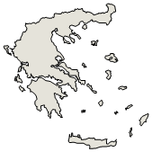
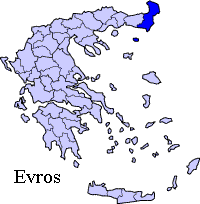
Regional unit : Evros
|
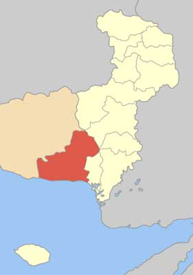
Municipality Alexandroupolis |
Alexandroupoli (Greek: Αλεξανδρούπολη, [aleksanˈðrupoli]; Turkish: Dedeağaç, formerly Ἀλεξανδρούπολις, Alexandroupolis), is a city of Greece and the capital of the Evros peripheral unit in Thrace. Named after King Alexander, it is an important port and commercial center of northeastern Greece.
Name
In the 19th century and early 20th century, Alexandroupoli was known as Dedeagatch Dedeagatsh (Greek: Δεδεαγάτς, Turkish: Dedeağaç), Bulgarian: Дедеагач), meaning "grandfather tree". (The word dede means "grandfather" and the word ağaç means "tree" in Turkish.) The name was based on a local tradition of a wise dervish who spent much of his time in the shade of a local tree and was eventually buried beside it.
Geography
Thracian Sea.
Alexandroupoli is about 14.5 km (9.0 mi) west of the delta of the river Evros, 40 km from the border with Turkey, 346 km (215 mi) from Thessaloniki on the newly constructed Egnatia highway, and 750 km (470 mi) from Athens. Around the city one finds small fishing villages like Makri and Dikella to the west, and suburbanm Maistros, Apalos, Antheia, Aristino, Nipsa, Loutra to the east, while north of the city are the ever closing Palagia, Abantas, Aissymi and Kirkas. At the 2001 census, the main city had a population of 48,885 and the municipal unit had a population of 52,720. The current metropolitan population is estimated at around 70,000 inhabitants, and its area covers the southern portion of the prefecture, and it runs from the Rhodope Prefecture to the Evros Delta. The municipality has a land area of 1,220 km² (468.73 sq mi). Besides Alexandroúpolis, its other largest settlements are the villages of Mákri (pop. 820), Ávas (497), Sykorráchi (309), Aisými (289), and Díkella (288).
Climate
| Climate data for Alexandroupoli | |||||||||||||
|---|---|---|---|---|---|---|---|---|---|---|---|---|---|
| Month | Jan | Feb | Mar | Apr | May | Jun | Jul | Aug | Sep | Oct | Nov | Dec | Year |
| Record high °C (°F) | 17 (63) |
24 (75) |
24 (75) |
26 (79) |
32 (90) |
36 (97) |
38 (100) |
39 (102) |
34 (94) |
32 (90) |
23 (73) |
22 (72) |
39 (102) |
| Average high °C (°F) | 8 (46) |
9 (48) |
12 (53) |
17 (62) |
22 (71) |
26 (79) |
29 (85) |
29 (85) |
26 (78) |
20 (68) |
14 (57) |
10 (50) |
18.4 (65.2) |
| Average low °C (°F) | 1 (34) |
2 (35) |
4 (39) |
7 (45) |
12 (53) |
16 (60) |
18 (65) |
18 (65) |
14 (58) |
11 (52) |
7 (44) |
3 (38) |
9.4 (49.0) |
| Record low °C (°F) | −11 (12) |
−13 (8) |
−12 (11) |
−1 (30) |
2 (35) |
8 (46) |
9 (48) |
9 (48) |
5 (41) |
−1 (30) |
−5 (23) |
−9 (15) |
−13 (8) |
| Avg. rainy days | 8 | 8 | 9 | 10 | 10 | 6 | 5 | 2 | 4 | 7 | 10 | 11 | 90 |
| Sunshine hours | 155 | 168 | 217 | 240 | 279 | 330 | 372 | 341 | 270 | 217 | 150 | 155 | 2,894 |
| Source: Weatherbase [1] | |||||||||||||
Municipality
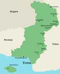
The municipality of Alexandroupolis was created in 2011 by the merger of the following 3 former municipalities, that became municipal units:[2]
Alexandroupolis
Feres
Traianoupoli
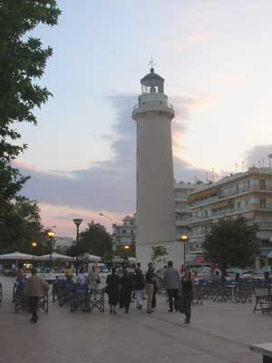
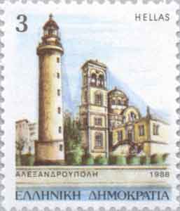
The Pharos of Alexandroupolis
Communities
The municipal unit Alexandroupoli is subdivided into the following communities (constituent settlements in brackets):
Alexandroupoli (Alexandroupoli, Agnantia, Amfitriti)
Aisymi (Aisymi, Leptokarya)
Avas
Kirki
Makri (Makri, Dikella, Ennato, Koimisi Theotokou, Mesimvria, Panorama, Paralia Dikellon, Plaka)
Sykorrachi (Sykorrachi, Atarni, Avra, Komaros, Mesti, Perama, Stathmos)
History
Ruins of Avandas castle outside the city.
The settlement's history only goes back to the 19th century. Long used as a landing ground for fishermen from the coast of Samothrace opposite, a hamlet developed in the area during the construction of a railway line connecting Istanbul to the major cities of Macedonia from Kuleliburgaz. The work was part of an effort to modernise the Ottoman Empire, and was assigned to engineers from Austria-Hungary. The settlement soon grew into a fishing village known as Dedeagatch.
Russo-Turkish War
Dedeagatch was captured by the Russians during the Russo–Turkish War of 1877–1878, and Russian forces settled in the village. The officers in charge saw that reconstruction incorporated wide streets running parallel to each other, allowing the quick advance of troops, and avoided cul-de-sacs. This was very unlike the narrow alleys, cobbled streets, and dead-ends that were characteristic of Ottoman cities at the time. The city returned to Ottoman control by the end of the war, but the brief Russian presence had a lasting effect on the design of Alexandroúpolis's streets.
Balkan Wars
The building of a railway station in Dedeagatch led to the development of the village into a town, and a minor trade centre by the end of the century. The town became the seat of a Pasha. Ottoman control of the town would last until the Balkan Wars. On 8 November 1912, Dedeagatch and its station was captured by Bulgarian forces with the assistance of the Hellenic Navy. Bulgaria and Greece were allies during the First Balkan War, but opponents in the Second Balkan War. Dedeagatch was captured by Greek forces on 11 July 1913. The Treaty of Bucharest (10 August 1913) however, determined that Dedeagatch would be returned to Bulgaria along with the rest of Western Thrace.
World War I
The defeat of Bulgaria by the Allies in World War I (1914–1918) ensured another change of hands for the town. Western Thrace was withdrawn from Bulgaria under the terms of the 1919 Treaty of Neuilly.[3] Alexandroupoli was under temporary management of the Entente led by French General Sharpe. During French occupation the Western Thrace Turk Republic was revived for 1 year. In the second half of April 1920 in San Remo conference of the prime ministers of the main allies of the Entente powers (except USA) Western Thrace was given to Greece. However, Bulgaria retained the right of transit to use the port of Dedeagatch to transport goods through the Aegean Sea. The change of guard between Bulgarian and Greek officials occurred on May 14, 1920. The city was soon visited by Alexander I of Greece amidst great celebration. He was the first King of Greece to visit the town which was renamed in his honor.
Greco-Turkish War
Following the defeat of Greece in the Greco-Turkish War (1919–1922), the Greek Army under General Theodoros Pangalos retreated from Eastern Thrace to the area of Alexandroupoli. Bulgaria used the opportunity of the Greek defeat to demand that Alexandroupoli either be returned to its control or declared a neutral zone under international control. Both demands were soundly rejected by the Greek leadership and found no support in the League of Nations.
The Treaty of Lausanne (24 July 1923) affirmed that Western Thrace and Alexandroupoli would continue to be controlled by Greece. A previous agreement allowing a Bulgarian presence in the town port had expired.
World War II
During World War II (see Axis Occupation of Greece during WWII), the Nazis gave Alexandroupoli to their lesser Bulgarian partners[4] Alexandroupoli was subsequently under Bulgarian occupation between May 1941 and 1944. The city suffered some damage to buildings and loss of population during the war, but was largely spared the effects of the Greek Civil War (1946–1949). Forces of the communist Democratic Army of Greece in and around the town area were small and loosely organized, resulting in the absence of major battles in the area; the return of peace allowed for Alexandroupoli to grow from a town of 16,332 residents (1951) to a city of 35,999 residents by 1981.
Recently in Alexandroupoli
The lighthouse of the city.
It has a sister city, Edirne, since November 30, 2007.[5]
2009 photos of Alexandroupolis
Education
Alexandroupoli houses four Departments of the Democritus University of Thrace (based in Komotini). These Departments are the following: Department of Medicine, Department of Molecular Biology and Genetics, Department of Primary Level Education and Department of Education Sciences in Pre-School Age. Some highly specialised medical operations are performed in the new Regional University Hospital - Research center, currently the largest one in the Balkans.
The city has a network of public schools, from nurseries to high schools, under the responsibility of the city council (though the student are subjects under the responsibility of the Ministry of Education). There are also many private language schools, most of them offering European Languages courses. Languages spoken by the citizens include: Greek, English, Russian, Bulgarian, Armenian, German, and Turkish. The city has a reputation of consistently exporting high number of students to attend national and international universities.
Transportation
The old military train station (Gare Militaire) of Alexandroupoli.
Alexandroupoli is served by Dimokritos International Airport (IATA:AXD) in the suburbs of Apalos, about 6 km from Alexandroupoli city center. It is one of the busiest airports in Greece and a main hub for Olympic Airways and Aegean; there are 6 daily flights to Athens, and also flights to Crete, while during the summer months some seasonal flights operate to\from Germany and Russia. The airport is connected to the city by highway, taxi services and scheduled bus services. The port of Alexandroupolis has been used principally by travellers. There are daily services to the Island of Samothraki and a weekly Trans-Aegean service to all the eastern islands of the Aegean, with the final destination of the island of Rhodes.
Trains run frequently to Thessaloniki and Athens, Burgas in Bulgaria and Edirne or Istanbul in Turkey. There is an extensive network of train and bus replacements services throughout the region of Evros.
The bus network is much more extensive and frequent. Hourly buses to the major municipalities within Macedonia and Thrace offered from the Regional Coaches KTEL as well as daily services to Bulgaria and Turkey. OSE-Varan and Ulusoy have daily services to Istanbul and Athens each and depart from Alexandroupolis Train Station in early mornings.
Notable people
Duke Ter Hachatrjan Aleksandr
Todor Dinov (1919–2004), Bulgarian graphic artist and animator
Hrysopiyi Devetzi (1976), Greek athlete
Demis Nikolaidis (1973), Greek footballer
Athanasios Tsigas (1982), Greek footballer
Lefteris Hapsiadis (1953), Greek Lyrics Creator and Writer
Historical population
Year Town Municipality
1981 35,999 -
1991 37,904 41,860
2001 48,885 52,720
See also
Communities of the Evros prefecture.
Burgas-Alexandroupoli pipeline
References
^ "Weatherbase: Weather For Alexandroupoli, Greece". Weatherbase. 2011. Retrieved on November 23, 2011.
^ Kallikratis law Greece Ministry of Interior (Greek)
^ Treaty of Neuilly, article 27 (3), 48
^ K.Svolopoulos, Greek Foreign Policy 1945-1981
^ http://www.samanyoluhaber.com/sondakika-81569.html Edirne and Alexandroupoli became sister cities
Greece :
A - B - C - D - E - F - G - H - I - J - K - L - M -
N - O - P - Q - R - S - T - U - V - W - X - Y - Z
| Ancient Greece
Science, Technology , Medicine , Warfare, , Biographies , Life , Cities/Places/Maps , Arts , Literature , Philosophy ,Olympics, Mythology , History , Images Medieval Greece / Byzantine Empire Science, Technology, Arts, , Warfare , Literature, Biographies, Icons, History Modern Greece Cities, Islands, Regions, Fauna/Flora ,Biographies , History , Warfare, Science/Technology, Literature, Music , Arts , Film/Actors , Sport , Fashion --- |
From Wikipedia, All text is available under the terms of the GNU Free Documentation License
