
.
Las Vegas, /lɑːs ˈveɪɡəs/ (locally, also pronounced as /lɑːs ˈvɛɡɨs/) officially the City of Las Vegas and often known as simply Vegas, is a city in the United States, the most populous city in the state of Nevada, the county seat of Clark County, and the city proper of the Las Vegas Valley.[5] Las Vegas is an internationally renowned major resort city known primarily for gambling, shopping, fine dining and nightlife and is the leading financial and cultural center for Southern Nevada.
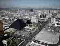
Aerial view of Las Vegas, Las Vegas, Las Vegas,
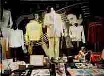


Elvis Museum, Siegfried & Roy, Monte Carlo Hotel view,
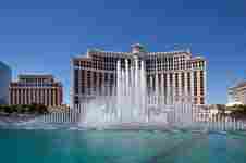
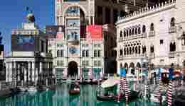
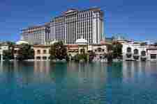
Bellagio Hotel Fountains, Venetian Hotel , Caesars Palace,
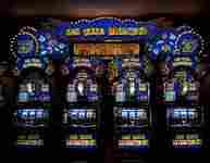
Slot machine arcade, Showgirl,
The city bills itself as The Entertainment Capital of the World, and is famous for its mega casino–hotels and associated entertainment. A growing retirement and family city, Las Vegas is the 29th-most populous city in the United States, with a population of 603,488 at the 2013 United States Census Estimates.[6] The 2013 population of the Las Vegas metropolitan area was 2,027,828.[4] The city is one of the top three leading destinations in the United States for conventions, business, and meetings and is one of the wealthiest major cities in the country.[7][8] In addition, the city's metropolitan area has more AAA Five Diamond hotels than any other city in the world, and is a global leader in the hospitality industry.[9][10] Today, Las Vegas is one of the top tourist destinations in the world.[11][12]
Established in 1905, Las Vegas was incorporated as a city in 1911. At the close of the 20th century, Las Vegas was the most populous American city founded in that century (a similar distinction retained by Chicago in the 19th century). The city's tolerance for numerous forms of adult entertainment earned it the title of Sin City, and has made Las Vegas a popular setting for films, television programs, and music videos.
Las Vegas is generally used to describe not just the city itself, but areas beyond the city limits—especially the resort areas on and near the Las Vegas Strip—and the Las Vegas Valley. The 4.2 mi (6.8 km) stretch of South Las Vegas Boulevard known as the Las Vegas Strip is in the unincorporated communities of Paradise, Winchester, and Enterprise, located in Clark County.[13][14]
History
Main article: History of Las Vegas
See also: Timeline of Las Vegas
Southern Paiutes at Moapa wearing traditional Paiute basket hats with Paiute cradleboard and rabbit robe
Golden Nugget and Pioneer Club along Fremont Street in 1952.
Fremont Street in the late 1960s.
Perhaps the earliest visitors to the Las Vegas area were nomadic Paleo-Indians, who traveled here 10,000 years ago, leaving behind petroglyphs. Anasazi and Paiute tribes followed at least 2,000 years ago.
A young Mexican scout named Rafael Rivera is credited as the first non-Native American to encounter the valley, in 1829.[15][16][17][18] Trader Antonio Armijo led a 60-man party along the Spanish Trail to Los Angeles, California in 1829.[19][20] The area was named Las Vegas, which is Spanish for "the meadows", as it featured abundant wild grasses, as well as desert spring waters for westward travelers.[21] The year 1844 marked the arrival of John C. Fremont, whose writings helped lure pioneers to the area. Downtown Las Vegas' Fremont Street is named after him.
Eleven years later members of the LDS Church chose Las Vegas as the site to build a fort halfway between Salt Lake City and Los Angeles, where they would travel to gather supplies. The fort was abandoned several years afterward. The remainder of this Old Mormon Fort can still be seen at the intersection of Las Vegas Boulevard and Washington Avenue.
Las Vegas was founded as a city in 1905, when 110 acres (45 ha) of land adjacent to the Union Pacific Railroad tracks were auctioned in what would become the downtown area. In 1911, Las Vegas was incorporated as a city.
1931 was a pivotal year for Las Vegas. At that time, Nevada legalized casino gambling and reduced residency requirements for divorce to six weeks. This year also witnessed the beginning of construction on nearby Hoover Dam. The influx of construction workers and their families helped Las Vegas avoid economic calamity during the Great Depression. The construction work was completed in 1935.
In 1941, the Las Vegas Army Air Corps Gunnery School was established. Currently known as Nellis Air Force Base, it is home to the aerobatic team called the Thunderbirds.
Following World War II, lavishly decorated hotels, gambling casinos and big-name entertainment became synonymous with Las Vegas.
The 1950s saw the opening of the Moulin Rouge, the first racially integrated casino-hotel in Las Vegas.
In 1951, nuclear weapons testing began at the Nevada Test Site, 65 miles (105 km) northwest of Las Vegas. City residents and visitors were able to witness the mushroom clouds until 1963 when the limited Test Ban Treaty required that nuclear tests be moved underground.
The iconic "Welcome to Las Vegas" sign, which was never located in the city, was created in 1959 by Betty Willis, who never copyrighted it.[22]
During the 1960s, corporations and business powerhouses such as Howard Hughes were building and buying hotel-casino properties. Gambling was referred to as "gaming," which transitioned into legitimate business.
In 1989, entrepreneur Steve Wynn changed the face of the Las Vegas gaming industry by opening up The Mirage, the Las Vegas Strip's first mega-casino resort.
The year 1995 marked the opening of the Fremont Street Experience in Las Vegas' downtown area. This canopied, five-block area features 12.5 million LED lights and 550,000 watts of sound from dusk until midnight during shows held on the top of each hour.
Due to years of revitalization efforts, 2012 was dubbed "The Year of Downtown". Hundreds of millions of dollars' worth of projects made their debut at this time. They included The Smith Center for the Performing Arts and DISCOVERY Children's Museum, the Mob Museum, the Neon Museum, a new City Hall complex and renovations for a new Zappos.com corporate headquarters in the old City Hall building.[21][23]
Geography and climate
Astronaut photograph of Las Vegas at night
Las Vegas is situated within Clark County in a basin on the floor of the Mojave Desert[24] and is surrounded by mountain ranges on all sides. Much of the landscape is rocky and arid with desert vegetation and wildlife. It can be subjected to torrential flash floods, although much has been done to mitigate the effects of flash floods through improved drainage systems.[25]
The peaks surrounding Las Vegas reach elevations of over 10,000 feet (3,000 m), and act as barriers to the strong flow of moisture from the surrounding area. The elevation is approximately 2,030 ft (620 m) above sea level. According to the United States Census Bureau, the city has a total area of 135.86 sq mi (351.9 km2), of which 135.81 sq mi (351.7 km2) is land and 0.05 sq mi (0.13 km2) (0.03%) is water.
Within the city there are many lawns, trees and other greenery. Due to water resource issues, there has been a movement to encourage xeriscapes. Another part of conservation efforts is scheduled watering days for residential landscaping. A U.S. Environmental Protection Agency grant in 2008 funded a program that analyzed and forecast growth and environmental impacts through the year 2019.
Climate
Desert scene near Red Rock Canyon in the Las Vegas area
Las Vegas' climate is a subtropical, hot desert climate (Köppen climate classification: BWh), typical of the Mojave Desert in which it lies. The city enjoys abundant sunshine year-round; it has an average of about 310 sunny days per year.[26] It is virtually free of tornadoes and ice storms. Dewpoints in the summer are exceptionally low, ranging from 40.6 °F (4.8 °C) to 44.0 °F (6.7 °C).[27]
The summer months of June through September are very hot and mostly dry, with a July daily average temperature of 92.5 °F (33.6 °C), while nighttime temperatures often remain above 80 °F (27 °C). There are an average of 134 days of 90 °F (32 °C)+ highs, and 74 days of 100 °F (38 °C)+ highs,[27] with most of the days in July and August exceeding the latter benchmark, and only occasionally failing to reach the former. Humidity is very low, often under 10%.
Las Vegas' winters are short and the season is generally mild. December, the coolest month, averages 47.7 °F (8.7 °C). The mountains surrounding Las Vegas accumulate snow during the winter, but snow is rare in the Las Vegas Valley itself. Most recently, on December 16, 2008, Las Vegas received 3.6 inches (9.1 cm).[28] Temperatures reach the freezing mark on 16 nights of the year but rarely sink to 20 °F (−7 °C).[27]
Annual precipitation in Las Vegas is about 4.2 in (110 mm), which on average falls 26–27 days per year.[27] Most of the precipitation falls in the winter, but even the wettest month (February) has on average only four days of precipitation.
| Climate data for McCarran International Airport (Paradise, Nevada), 1981–2010 normals, extremes 1937–present | |||||||||||||
|---|---|---|---|---|---|---|---|---|---|---|---|---|---|
| Month | Jan | Feb | Mar | Apr | May | Jun | Jul | Aug | Sep | Oct | Nov | Dec | Year |
| Record high °F (°C) | 77 (25) |
87 (31) |
92 (33) |
99 (37) |
109 (43) |
117 (47) |
117 (47) |
116 (47) |
113 (45) |
103 (39) |
87 (31) |
78 (26) |
117 (47) |
| Average high °F (°C) | 58.0 (14.4) |
62.5 (16.9) |
70.3 (21.3) |
78.3 (25.7) |
88.9 (31.6) |
98.7 (37.1) |
104.2 (40.1) |
102.0 (38.9) |
94.0 (34.4) |
80.6 (27) |
66.3 (19.1) |
56.6 (13.7) |
80.1 (26.7) |
| Average low °F (°C) | 39.4 (4.1) |
43.4 (6.3) |
49.4 (9.7) |
56.1 (13.4) |
65.8 (18.8) |
74.6 (23.7) |
80.9 (27.2) |
79.3 (26.3) |
71.1 (21.7) |
58.5 (14.7) |
46.5 (8.1) |
38.7 (3.7) |
58.7 (14.8) |
| Record low °F (°C) | 8 (−13) |
16 (−9) |
19 (−7) |
31 (−1) |
38 (3) |
48 (9) |
56 (13) |
54 (12) |
43 (6) |
26 (−3) |
15 (−9) |
11 (−12) |
8 (−13) |
| Average precipitation inches (mm) | 0.54 (13.7) |
0.76 (19.3) |
0.44 (11.2) |
0.15 (3.8) |
0.12 (3) |
0.07 (1.8) |
0.40 (10.2) |
0.33 (8.4) |
0.25 (6.4) |
0.27 (6.9) |
0.36 (9.1) |
0.50 (12.7) |
4.19 (106.4) |
| Average precipitation days (≥ 0.01 in) | 3.1 | 4.0 | 2.9 | 1.6 | 1.2 | 0.6 | 2.5 | 2.6 | 1.6 | 1.7 | 1.7 | 3.0 | 26.5 |
| Average relative humidity (%) | 45.1 | 39.6 | 33.1 | 25.0 | 21.3 | 16.5 | 21.1 | 25.6 | 25.0 | 28.8 | 37.2 | 45.0 | 30.3 |
| Mean monthly sunshine hours | 245.2 | 246.7 | 314.6 | 346.1 | 388.1 | 401.7 | 390.9 | 368.5 | 337.1 | 304.4 | 246.0 | 236.0 | 3,825.3 |
| Percent possible sunshine | 79 | 81 | 85 | 88 | 89 | 92 | 88 | 88 | 91 | 87 | 80 | 78 | 86 |
| Source: NOAA (relative humidity and sun 1961–1990)[27][29][30] | |||||||||||||
Nearby communities
Homes in the affluent area of Summerlin, Nevada. Affluent neighborhoods are located throughout the Las Vegas Valley.
Henderson, Nevada, incorporated
North Las Vegas, Nevada, incorporated
Summerlin, Nevada, unincorporated
Paradise, Nevada, unincorporated
Enterprise, unincorporated
Sunrise Manor, Nevada, unincorporated
Spring Valley, Nevada, unincorporated
Boulder City, Nevada, incorporated
Demographics
Historical population
Census Pop. %±
1900 25 —
1910 800 3,100.0%
1920 2,304 188.0%
1930 5,165 124.2%
1940 8,422 63.1%
1950 24,624 192.4%
1960 64,405 161.6%
1970 125,787 95.3%
1980 164,674 30.9%
1990 258,295 56.9%
2000 478,434 85.2%
2010 583,756 22.0%
Est. 2014 613,599 [31] 5.1%
source:[6][32][33]
Demographic profile 2010[34] 2000[35] 1990[36] 1970[36]
White 62.1% 69.9% 78.4% 87.6%
—Non-Hispanic 47.9% 58.0% 72.1% 83.1%[37]
Black or African American 11.1% 10.4% 11.4% 11.2%
Hispanic or Latino (of any race) 31.5% 23.6% 12.5% 4.6%[37]
Asian 6.1% 4.8% 3.6% 0.7%
Downtown Las Vegas and Red Rock behind
According to the 2010 Census, the racial composition of Las Vegas was as follows:[38]
White: 62.1% (Non-Hispanic Whites: 47.9%; Hispanic Whites: 14.2%)
Hispanic or Latino (of any race): 31.5% (24.0% Mexican, 1.4% Salvadoran, 0.9% Puerto Rican, 0.9% Cuban, 0.6% Guatemalan, 0.2% Peruvian, 0.2% Colombian, 0.2% Honduran, 0.2% Nicaraguan)
Black or African American: 11.1%
Asian: 6.1% (3.3% Filipino, 0.7% Chinese, 0.5% Korean, 0.4% Japanese, 0.4% Indian, 0.2% Vietnamese, 0.2% Thai)
Two or more races: 4.9%
Native American: 0.7%
Native Hawaiian and Other Pacific Islander: 0.6%
Source:[39]
The city's most populous ethnic group, non-Hispanic Whites,[34] have proportionally declined from 72.1% of the population in 1990 to 47.9% in 2010, even as total numbers of all ethnicities have increased with the population.[36]
Hawaiians and Las Vegans sometimes refer to Las Vegas as the "ninth island of Hawaii" because so many Hawaiians have moved to the city.[40]
As of the census[41] of 2010, there were 583,756 people, 211,689 households, and 117,538 families residing in the city. The population density was 4,222.5/sq mi (1,630.3/km2). There are 190,724 housing units at an average density of 1,683.3/sq mi (649.9/km2).
As of 2006, there were 176,750 households, out of which 31.9% had children under the age of 18 living with them, 48.3% were married couples living together, 12.2% had a female householder with no husband present, and 33.5% were non-families. 25.0% of all households were made up of individuals and 7.5% had someone living alone who was 65 years of age or older. The average household size was 2.66 and the average family size was 3.20.
In the city, the population was spread out with 25.9% under the age of 18, 8.8% from 18 to 24, 32.0% from 25 to 44, 21.7% from 45 to 64, and 11.6% who were 65 years of age or older. The median age was 34 years. For every 100 females there were 103.3 males. For every 100 females age 18 and over, there were 102.5 males.
The median income for a household in the city was $53,000 and the median income for a family was $58,465.[42] Males had a median income of $35,511 versus $27,554 for females. The per capita income for the city was $22,060. About 6.6% of families and 8.9% of the population were below the poverty line, including 5.4% of those under age 18 and 6.3% of those age 65 or over.
According to a 2004 study, Las Vegas has one of the highest divorce rates.[43][44] The city's high divorce rate is not wholly due to Las Vegans themselves getting divorced. Since divorce is easier in Nevada than most other states, many people come from across the country for the easier process. Similarly, Nevada marriages are notoriously easy to get. Las Vegas has one of the highest marriage rates of U.S. cities, with many licenses issued to people from outside the area (see Las Vegas weddings).
Economy
The primary drivers of the Las Vegas economy are tourism, gaming and conventions, which in turn feed the retail and restaurant industries.
Tourism
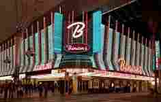
Fremont Street Experience
Golden Nugget Las Vegas
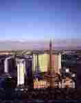
The Strip in late 2009
A view of the Las Vegas Valley looking south from the Stratosphere Tower at dusk
The major attractions in Las Vegas are the casinos and the hotels, although in recent years other new attractions have begun to emerge.
Most casinos in the downtown area are located on the Fremont Street Experience, The Stratosphere being one of the exceptions. Fremont East, adjacent to the Fremont Street Experience, was granted variances to allow bars to be closer together, similar to the Gaslamp Quarter of San Diego, the goal being to attract a different demographic than the Strip attracts.
Downtown casinos
Main article: Downtown (Nevada gaming area)
The Golden Gate Hotel & Casino, located downtown along the Fremont Street Experience, is the oldest continuously operating hotel and casino in Las Vegas; it opened in 1906 as the Hotel Nevada.
The year 1931 marked the opening of the Northern Club (now the La Bayou).[45][46] The most notable of the early casinos may have been Binion's Horseshoe (now Binion's Gambling Hall and Hotel) while it was run by Benny Binion.
Boyd Gaming has a major presence downtown operating the California Hotel & Casino, Fremont Hotel & Casino and the Main Street Casino. Other casinos operations include the Four Queens Hotel & Casino, Las Vegas Club and Mermaid's Casino, which are also located downtown along the Fremont Street Experience.
Downtown casinos that have undergone major renovations and revitalization in recent years include the Golden Nugget Hotel & Casino, The D Las Vegas Hotel Casino (formerly Fitzgerald's), Downtown Grand (formerly Lady Luck), El Cortez Hotel & Casino and The Plaza Hotel & Casino.[47]
Las Vegas Strip
The Las Vegas Strip, primarily located in Paradise.
Main article: Las Vegas Strip
The center of the gambling and entertainment industry, however, is located on the Las Vegas Strip, outside the city limits in the surrounding unincorporated communities of Paradise and Winchester in Clark County. The largest and most notable casinos and buildings are located there.
Development
See also: List of tallest buildings in Las Vegas
When The Mirage opened in 1989, it started a trend of major resort development on the Las Vegas Strip outside of the city. This resulted in a drop in tourism in the downtown area, but many recent projects have increased the number of visitors to downtown.
An effort has been made by city officials to diversify the economy by attracting health-related, high-tech and other commercial interests. No state tax for individuals or corporations, as well as a lack of other forms of business-related taxes,[48] have aided the success of these efforts.
With the Strip expansion in the 1990s, downtown Las Vegas - which has maintained an old Las Vegas feel - began to suffer. However, in recent years the city has made strides in turning around the fortunes of this urban area.
The Fremont Street Experience was built in an effort to draw tourists back to the area, and has been popular since its startup in 1995.
The city purchased 61 acres (25 ha) of property from the Union Pacific Railroad in 1995 with the goal of creating a better draw for more people to the downtown area. In 2004, Las Vegas Mayor Oscar Goodman announced plans for Symphony Park, which will include residential and office highrises.
Already operating in Symphony Park is the Cleveland Clinic Lou Ruvo Center for Brain Health (opened in 2010), The Smith Center for the Performing Arts (opened in 2012) and the DISCOVERY Children's Museum (opened in 2013).[49]
On land across from Symphony Park, the World Market Center Las Vegas opened in 2005. It currently encompasses three large buildings with a total of 5.1 million square feet. Trade shows for the furniture and furnishing industries are held there semiannually.
Also located nearby is the Las Vegas Premium Outlets - North, one of the top-performing outlet centers in its company's portfolio. It is currently undergoing a second expansion.[50]
A new Las Vegas City Hall opened in February 2013 on downtown's Main Street, another urban area ripe for development. The former City Hall building is now occupied by the corporate headquarters for the major online retailer, Zappos.com, which opened downtown in 2013. Zappos CEO Tony Hsieh has taken a personal, as well as a professional, interest in the urban area and is contributing $350 million of his personal wealth toward a multifaceted revitalization effort called the Downtown Project.[51][52] Projects funded include Las Vegas' first independent bookstore, The Writer's Block.[53]
Culture
Main article: Las Vegas Valley § Culture and the arts
Performing arts center and children's museum in Symphony Park in downtown Las Vegas.
The city is home to several museums including the Neon Museum (the location for many of the historical signs from Las Vegas' mid-20th century heyday), The Mob Museum, the Las Vegas Natural History Museum, the DISCOVERY Children's Museum, the Nevada State Museum and the Old Las Vegas Mormon State Historic Park.
The city is home to an extensive Downtown Arts District which hosts numerous galleries and events. "First Friday" is a monthly celebration that includes arts, music, special presentations and food in a section of the city's downtown region called 18b, The Las Vegas Arts District.[54] The festival extends into the Fremont East Entertainment District as well.[55]
The Thursday prior to First Friday is known in the arts district as "Preview Thursday." This evening event highlights new gallery exhibitions throughout the district.[56]
The Las Vegas Academy of International Studies, Performing and Visual Arts is a Grammy award-winning magnet school located in downtown Las Vegas.
The Smith Center for the Performing Arts is situated downtown in Symphony Park. The world-class performing arts center hosts Broadway shows and other major touring attractions, as well as orchestral, opera, ballet, choir, jazz, and dance performances.
Sports
Main article: Sports in the Las Vegas metropolitan area
Las Vegas does not have major league sports, although the metropolitan population is as large or larger than many cities that have them. The only minor league sports team that plays in the city of Las Vegas are the Las Vegas 51s of the Pacific Coast League, the AAA farm club of the New York Mets.
In response to continuing rumors of a potential National Hockey League expansion team in Las Vegas, ESPN writer Scott Burnside noted several obstacles that would be faced by the city if it were to become a professional sports market, including the presence of legal sports betting, scheduling conflicts with the large amount of residents who work nighttime and overnight shifts, and that the casinos would be unlikely to give away tickets to such events as a promotion, as they run contrary to a goal of encouraging patrons to remain in their facilities.[57]
Parks and recreation
Las Vegas has 68 parks. The city owns the land for, but does not operate, four golf courses: Angel Park Golf Club, Desert Pines Golf Club, Durango Hills Golf Club and the Las Vegas Municipal Golf Course. It is also responsible for 123 playgrounds, 23 softball fields, 10 football fields, 44 soccer fields, 10 dog parks, six community centers, four senior centers, 109 skates parks, six swimming pools and more.[58]
Government
Las Vegas City Hall in downtown Las Vegas
The city of Las Vegas government operates as a council–manager government. The Mayor sits as a Council member-at-large and presides over all of the City Council meetings. In the event that the Mayor cannot preside over a City Council meeting, the Mayor Pro-Tem is the presiding officer of the meeting until such time as the Mayor returns to his/her seat. The City Manager is responsible for the administration and the day-to-day operations of all municipal services and city departments. The City Manager maintains intergovernmental relationships with federal, state, county and other local governments.
Much of the Las Vegas metropolitan area is split into neighboring incorporated cities or unincorporated communities. Approximately 700,000 people live in unincorporated areas governed by Clark County, and another 465,000 live in incorporated cities such as North Las Vegas, Henderson and Boulder City. Las Vegas and Clark County share a police department, the Las Vegas Metropolitan Police Department, which was formed after a 1973 merger of the Las Vegas Police Department and the Clark County Sheriff's Department. North Las Vegas, Henderson, Boulder City and some colleges have their own police departments.
A Paiute Indian reservation occupies about 1 acre (0.40 ha) in the downtown area.
Las Vegas, home to the Lloyd D. George Federal District Courthouse and the Regional Justice Center, draws numerous companies providing bail, marriage, divorce, tax, incorporation and other legal services.
City council
Name Position Term
ends References Notes
Carolyn Goodman Mayor 2015 [59] Replaced her husband, Oscar Goodman, who was term-limited
Lois Tarkanian 1st Ward Council member 2015 [60]
Bob Beers 2nd Ward Council member 2017
Bob Coffin 3rd Ward Council member 2015 [59]
Stavros Anthony 4th Ward Council member 2017
Ricki Barlow 5th Ward Council member 2015 [60]
Steven Ross 6th Ward Council member 2017
Education
Main article: Las Vegas Valley § Education
Primary and secondary schools
Main article: Clark County School District
Primary and secondary public education is provided by the Clark County School District, which is the fifth most populous school district in the nation. Students totaled 314,653 in grades K-12 for school year 2013-2014.[61]
Colleges and universities
The College of Southern Nevada (the third largest community college in the United States by enrollment) is the main higher education facility in the city. Other institutions include the University of Nevada School of Medicine, with a campus in the city, and the for-profit private school Le Cordon Bleu College of Culinary Arts. Educational opportunities exist around the city; among them are the University of Nevada, Las Vegas and Nevada State College run by the Nevada System of Higher Education, Desert Research Institute, The International Academy of Design & Technology Las Vegas and Touro University Nevada.
Transportation
Main article: Transportation in Las Vegas
Regional Transportation Commission (RTC) provides public transportation
Inside Terminal 3 at McCarran International Airport, Paradise, Nevada
RTC Transit is a public transportation system providing bus service throughout Las Vegas, Henderson, North Las Vegas and other areas of the valley. Inter-city bus service to and from Las Vegas is provided by Greyhound. Amtrak trains have not served Las Vegas since the service via the Desert Wind was discontinued in 1997. Though no Amtrak trains have served Las Vegas since the Desert Wind was cancelled in 1997, Amtrak California operates Thruway Motorcoach dedicated service between the City and its passenger rail stations in Bakersfield, California, as well as Los Angeles Union Station via Barstow.[62]
A bus rapid-transit link in Las Vegas called the Strip & Downtown Express (previously ACE Gold Line[63]) with limited stops and frequent service was launched in March 2010, and connects downtown Las Vegas, the Strip and the Las Vegas Convention Center.
With some exceptions, including Las Vegas Boulevard, Boulder Highway (SR 582) and Rancho Drive (SR 599), the majority of surface streets in Las Vegas are laid out in a grid along Public Land Survey System section lines. Many are maintained by the Nevada Department of Transportation as state highways. The street numbering system is divided by the following streets:
Westcliff Drive, US 95 Expressway, Fremont Street and Charleston Boulevard divide the north–south block numbers from west to east.
Las Vegas Boulevard divides the east–west streets from the Las Vegas Strip to near the Stratosphere, then Main Street becomes the dividing line from the Stratosphere to the North Las Vegas border, after which the Goldfield Street alignment divides east and west.
On the east side of Las Vegas, block numbers between Charleston Boulevard and Washington Avenue are different along Nellis Boulevard, which is the eastern border of the city limits.
Interstates 15, 515, and US 95 lead out of the city in four directions. Two major freeways – Interstate 15 and Interstate 515/U.S. Route 95 – cross in downtown Las Vegas. I-15 connects Las Vegas to Los Angeles, and heads northeast to and beyond Salt Lake City, Utah. I-515 goes southeast to Henderson, beyond which US 93 continues over the Mike O'Callaghan–Pat Tillman Memorial Bridge towards Phoenix, Arizona. US 95 connects the city to northwestern Nevada, including Carson City and Reno. US 93 splits from I-15 northeast of Las Vegas and goes north through the eastern part of the state, serving Ely and Wells. US 95 heads south from US 93 near Henderson through far eastern California. A partial beltway has been built, consisting of Interstate 215 on the south and Clark County 215 on the west and north. Other radial routes include Blue Diamond Road (SR 160) to Pahrump and Lake Mead Boulevard (SR 147) to Lake Mead.
East–west roads, north to south[64]
Ann Road
Nevada 573.svg Craig Road (SR 573)
Nevada 574.svg Cheyenne Avenue (SR 574)
Smoke Ranch Road
Nevada 578.svg Washington Avenue (SR 578)
Summerlin Parkway
Nevada 579.svg Bonanza Road (SR 579)
Nevada 159.svg Charleston Boulevard (SR 159)
Nevada 589.svg Sahara Avenue (SR 589)
North–south roads, west to east
Fort Apache Road
Durango Drive
Buffalo Drive
Nevada 595.svg Rainbow Boulevard (SR 595)
Nevada 596.svg Jones Boulevard (SR 596)
Decatur Boulevard
Valley View Boulevard
Nevada 599.svg Rancho Drive
Maryland Parkway
Nevada 607.svg Eastern Avenue (SR 607)
Pecos Road
Nevada 610.svg Lamb Boulevard (SR 610)
Nevada 612.svg Nellis Boulevard (SR 612)
McCarran International Airport handles international and domestic flights into the Las Vegas Valley. The airport also serves private aircraft and freight/cargo flights. Most general aviation traffic uses the smaller North Las Vegas Airport and Henderson Executive Airport.
The Union Pacific Railroad is the only Class I railroad providing rail freight service to the city. Until 1997, the Amtrak Desert Wind train service ran through Las Vegas using the Union Pacific Railroad tracks.
Notable people
Main article: List of people from Las Vegas
See also
Portal icon Nevada portal
Portal icon United States portal
List of films set in Las Vegas
List of films shot in Las Vegas
List of Las Vegas casinos that never opened
List of mayors of Las Vegas
List of television shows set in Las Vegas
Radio stations in Las Vegas
Television stations in Las Vegas
References
Merriam Webster's Geographical Dictionary (3rd ed.). Merriam-Webster. 1997. p. 633. ISBN 9780877795469.
"Words and Their Stories: Nicknames for New Orleans and Las Vegas". VOA News. March 13, 2010. Retrieved January 29, 2012.
Lovitt, Rob (December 15, 2009). "Will the real Las Vegas please stand up?". MSNBC. Retrieved February 4, 2012.
"Profile of General Population and Housing Characteristics: 2010 Demographic Profile Data (DP-1): Las Vegas city, Nevada". U.S. Census Bureau, American Factfinder. Retrieved March 9, 2012.
"Find a County". National Association of Counties. Retrieved June 7, 2011.
"Geographic Identifiers: 2010 Demographic Profile Data (G001): Las Vegas city, Nevada; count revision of 01-07-2013". U.S. Census Bureau, American Factfinder. Retrieved March 9, 2012.
Jones, Charisse (August 21, 2013). "Top convention destinations: Orlando, Chicago, Las Vegas". USA Today.
[1]
Nancy Trejos, USA TODAY (January 17, 2014). "AAA chooses Five Diamond hotels, restaurants for 2014". Usatoday.com. Retrieved January 10, 2015.
"Top 5 Cities to Get Hired in Hospitality". Hcareers.com. Retrieved January 10, 2015.
"Overseas Visitation Estimates for U.S. States, Cities, and Census Regions: 2013" (PDF). International Visitation in the United States. US Office of Travel and Tourism Industries, US Department of Commerce. May 2014. Retrieved December 14, 2014.
"World's Most-Visited Tourist Attractions". Travel + Leisure. Retrieved January 10, 2015.
Joe Schoenmann (February 3, 2010). "Vegas not alone in wanting in on .vegas". Las Vegas Sun.
"County Turns 100 July 1, Dubbed 'Centennial Day'" (Press release). Clark County, Nevada. June 23, 2009. Retrieved February 5, 2010.
Lake, Richard (December 17, 2008). "Road Warrior Q&A: Foliage removed for widening". Retrieved October 3, 2013.
"Las Vegas, how did Las Vegas get its name, groundwater depletion, Victor Miguel Ponce". Lasvegas.sdsu.edu. Retrieved September 13, 2014.
"History of Las Vegas". Lvol.com. Retrieved September 13, 2014.
Barbara Land, Myrick Land, "A short history of Las Vegas", University of Nevada Press, 2004, p. 4.
"Clark County, NV – FAQs/History". Retrieved December 4, 2008.
"HOW DID LAS VEGAS GET ITS NAME?". HOW DID LAS VEGAS GET ITS NAME?. Retrieved July 27, 2013.
"History". City of Las Vegas. Archived from the original on July 1, 2014. Retrieved July 15, 2014.
"A Neon Come-Hither, Still Able to Flirt". The New York Times. Retrieved 10 January 2015.
Downtown Las Vegas Visitors Guide, 2014
"Geography of Las Vegas, Nevada". geography.about.com. Retrieved February 25, 2014.
"Flood control a success - Las Vegas Review-Journal". Las Vegas Review-Journal. Retrieved September 13, 2014.
Source: National Weather Service Forecast Office, November 2012
"NowData - NOAA Online Weather Data". National Oceanic and Atmospheric Administration. Retrieved 2013-07-01.
"KLAS-TV on many broadcasts along with other stations broadcasts". Lasvegasnow.com. November 13, 2007. Retrieved July 13, 2009.
"Station Name: NV LAS VEGAS MCCARRAN AP". National Oceanic and Atmospheric Administration. Retrieved 2013-03-20.
"WMO Climate Normals for LAS VEGAS/MCCARRAN, NV 1961–1990". National Oceanic and Atmospheric Administration. Retrieved 2014-03-11.
"Annual Estimates of the Resident Population for Incorporated Places: April 1, 2010 to July 1, 2014". Retrieved June 4, 2015.
Moffatt, Riley. Population History of Western U.S. Cities & Towns, 1850–1990. Lanham: Scarecrow, 1996, 159.
"Annual Estimates of the Resident Population for Incorporated Places of 50,000 or More, Ranked by July 1, 2013 Population: April 1, 2010 to July 1, 2014 (PEPANNRSIP)". U.S. Census Bureau, American Factfinder. Retrieved October 16, 2014.
"Las Vegas (city), Nevada". State & County QuickFacts. U.S. Census Bureau. Retrieved April 20, 2012.
"Race and Hispanic or Latino: 2000". United States Census Bureau.
"Nevada - Race and Hispanic Origin for Selected Cities and Other Places: Earliest Census to 1990". U.S. Census Bureau. Retrieved April 20, 2012.
From 15% sample
"Data Access and Dissemination Systems (DADS)". Factfinder2.census.gov. Retrieved September 13, 2014.
"Las Vegas, Nevada 2010 Census Profile". census.gov. Retrieved April 21, 2011.
"Las Vegas: Bright Lights, Big City, Small Town". State of the Reunion. Retrieved July 5, 2013.
"American FactFinder". United States Census Bureau. Retrieved January 31, 2008.
American FactFinder, United States Census Bureau. "Census". Factfinder.census.gov. Retrieved July 13, 2009.
"Most Stressful US City". City Mayors. January 10, 2004. Retrieved July 13, 2009.
Blakeslee, Sandra (December 16, 1997). "Health: Suicide Rate Higher in 3 Gambling Cities, Study Says". New York Times. Retrieved July 13, 2009.
Rinella, Heidi Knapp (July 27, 2000). "New book raises questions about Silver State". Las Vegas Review-Journal.
"Fremont Street Experience Brings Downtown Las Vegas Into Next Century". Fremont Street Experience. Retrieved December 8, 2008.
2013 Fiscal Year In Review, city of Las Vegas Economic and Urban Development Projects, "A New Downtown Emerges."
"LVRDA". Lvrda.org. Retrieved January 10, 2015.
[2][dead link]
"Premium Outlets: Las Vegas". Premiumoutlets.com. Retrieved September 13, 2014.
"Downtown Project - Revitalizing Downtown Las Vegas". Downtownproject.com. Retrieved September 13, 2014.
[3][dead link]
"Despite E-Books, Independent Bookstore Gambling on Downtown Las Vegas". Webcitation.org. Retrieved 2015-05-30.
"18b Las Vegas Art District - 18b". 18b.org. Retrieved September 13, 2014.
"First Friday Main Menu - First Friday Las Vegas Network". Firstfridaylasvegas.com. Retrieved September 13, 2014.
[4][dead link]
Burnside, Scott (August 27, 2014). "Expansion a tricky game for NHL". ESPN.com. ESPN Internet Ventures. Retrieved August 31, 2014.
"City of Las Vegas - Find Parks and Facilities". Lasvegasnevada.gov. Retrieved 10 January 2015.
"2011 Municipal Primary Election April 5, 2011". Clark County, Nevada. April 5, 2011. Retrieved June 14, 2011.
"2011 Municipal Primary Election April 5, 2011". Clark County, Nevada. April 5, 2011. Retrieved June 14, 2011.
Source: city of Las Vegas Planning Department, MAY 2014.
"California-Train and Thruway service" (PDF). Retrieved June 18, 2013.
Green, Steve (August 17, 2011). "Lawsuit prompts RTC to drop 'ACE' name from bus lines". Las Vegas Sun. Retrieved March 1, 2011.
Most arterial roads are shown, as indicated on the Nevada Department of Transportation's Roadway functional classification: Las Vegas urbanized area map. Retrieved November 12, 2011.
Further reading
Chung, Su Kim (2012). Las Vegas Then and Now, Holt: Thunder Bay Press, ISBN 978-1-60710-582-4
Stierli, Martino (2013). Las Vegas in the Rearview Mirror: The City in Theory, Photography, and Film, Los Angeles: Getty Publications, ISBN 978-1-60606-137-4
Venturi, Robert (1972). Learning from Las Vegas: The Forgotten Symbolism of Architectural Form, Cambridge: MIT Press, ISBN 978-0-26272-006-9
External links
City of Las Vegas official website
"The Making of Las Vegas" (historical timeline)
Geologic tour guide of the Las Vegas area from American Geological Institute
National Weather Service Forecast – Las Vegas, NV
Retrieved from "http://en.wikipedia.org"
All text is available under the terms of the GNU Free Documentation License
