
.
STATE OF COLORADO
John A. Love, Governor
DEPARTMENT OF NATURAL RESOURCES
T. W. Ten Eyck, Executive Director
COLORADO GEOLOGICAL SURVEY
John W. Rold, State Geologist and Director
A. L. Hornbaker, Mineral Deposits Geologist
Richard H. Pearl, Ground Water Geologist
William P. Rogers, Engineering Geologist
Antoinette M. Ray, Secretary
MISSION OF THE COLORADO GEOLOGICAL SURVEY
The Colorado Geological Survey was legislatively re-established in February 1969 to meet the geologic needs of the citizens, governmental agencies, and mineral industries of Colorado. This modern legislation was aimed at applying geologic knowledge toward the solution of today’s and tomorrow’s problems of an expanding population, mounting environmental concern, and the growing demand for mineral resources.
SPECIFIC LEGISLATIVE CHARGES:
- “Assist, consult with, and advise state and local governmental agencies on geologic problems.”
- “Promote economic development of mineral resources.”
- “Evaluate the physical features of Colorado with reference to present and potential human and animal use.”
- “Conduct studies to develop geologic information.”
- “Inventory the state’s mineral resources.”
- “Collect, preserve and distribute geologic information.”
- “Determine areas of geologic hazard that could affect the safety of or economic loss to the citizens of Colorado.”
- “Prepare, publish, and distribute geologic reports, maps, and bulletins.”
PRAIRIE
PEAK and
PLATEAU
A GUIDE TO THE GEOLOGY OF COLORADO
by John and Halka Chronic
COLORADO GEOLOGICAL SURVEY BULLETIN 32
1972
Available from Colorado Geological Survey
1845 Sherman Street
Denver, Colorado 80203
Price—$2.00
ACKNOWLEDGMENTS
This guidebook was written at the request of the Colorado Geological Survey to fulfill a long-felt need for a popular account of the state’s geology and its relationship to Man.
The authors wish to thank those of their colleagues who have assisted at various times in the preparation of this book. John Rold, Colorado State Geologist, and William Weber, of the University of Colorado Museum staff, made many helpful suggestions concerning the manuscript. John Schooland, vice president of the Colorado Historical Society, generously provided several pictures of early mining activities in Colorado. Permission to reproduce drawings and paintings of fossils and reconstructions of past environments was granted by the American Museum of Natural History and the University of Colorado Museum. Drawings, maps, and diagrams are largely the work of Robert Maurer, who also designed the cover and title page.
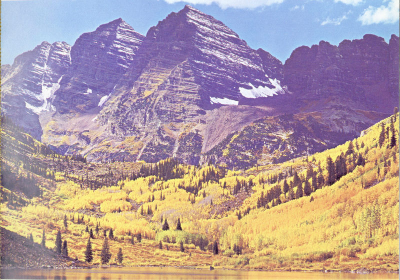
Tilted dark red sedimentary rocks of the Pennsylvanian-Permian Maroon Formation are well exposed in the cliffs of Maroon Bells, southwest of Aspen. (Photo courtesy Hydraulic Unlimited Mfg. Co.)
CONTENTS
- Page
- Introduction 1
- I Colorado’s Three Provinces 3
- The Prairies 8
- The Peaks 10
- Front Range 11
- Wet Mountains 16
- Sangre de Cristo Range and Spanish Peaks 17
- Park Range and Rabbit Ears Range 19
- Gore Range 20
- Tenmile and Mosquito Ranges 21
- Sawatch Range 22
- Elk Mountains and West Elk Mountains 24
- San Juan Mountains 25
- Uinta Mountains 26
- The Plateaus 28
- II Geologic History of Colorado 32
- Precambrian Era 33
- Paleozoic Era 38
- Cambrian Period 39
- Ordovician Period 40
- Silurian Period 42
- Devonian Period 42
- Mississippian Period 43
- Pennsylvanian Period 44
- Permian Period 48
- Mesozoic Era 51
- Triassic Period 51
- Jurassic Period 52
- Cretaceous Period 56
- Cenozoic Era 59
- Tertiary Period 59
- Quaternary Period 68
- III Geology and Man in Colorado 74
- Gold, Silver, and Other Metals 77
- Boulder County 79
- Central City and Idaho Springs 80
- Georgetown, Empire, and Silver Plume 81
- Leadville 82
- Breckenridge 83
- Fairplay 84
- Silverton 85
- Ouray 87
- Aspen 88
- Creede 89
- Cripple Creek 90
- Climax 91
- Radium, Uranium, and Vanadium 93
- Oil, Natural Gas, and Oil Shale 94
- Coal 96
- Construction Materials 97
- Sand, Gravel, and Clay 97
- Stone 99
- Lime and Gypsum 101
- Gems 102
- Water 103
- Surface Water 103
- Groundwater 105
- Caves 106
- Springs 109
- Environmental Geology 111
- Glossary 114
- Suggested Reading 119
- Index 121
ILLUSTRATIONS
- Page
- Colorado’s three geologic provinces 2
- Pikes Peak, seen from the Garden of the Gods 4
- Rock classification (chart) 5
- Stratigraphic column (chart) 7
- Jurassic rocks in Colorado (map) 9
- East face of Longs Peak 11
- Rocky Mountain National Park (east-west profile) 12
- Big Thompson Canyon, west of Loveland 13
- Red Rocks Amphitheater, west of Denver 14
- Colorado Springs area (map and cross section) 15
- Joint systems in Precambrian rocks, Boulder Canyon 15
- Spanish Peaks, southwest of Walsenburg 18
- Hahn’s Peak, north of Steamboat Springs 19
- Gore Range from the east 20
- Aspen Mountain geology (map) 23
- Mt. Sopris, south of Glenwood Springs 24
- Ouray, in the San Juan Mountains 25
- Steamboat Rock, Dinosaur National Monument 27
- Grand Hogback, near Rifle (block diagram) 28
- Mt. Garfield, near Grand Junction 30
- Precambrian-Cambrian unconformity south of Ouray 34
- Geologic map of Colorado 35
- Black Canyon of the Gunnison National Monument 36
- Precambrian-Cambrian unconformity, Glenwood Canyon 38
- Cambrian fossils 39
- Ordovician fossils 41
- Devonian fossils 43
- Mississippian fossils 44
- Pennsylvanian paleogeography (map) 45
- Fountain Formation northwest of Denver 45
- Pennsylvanian fossils 46
- Contorted Pennsylvanian rocks near Gypsum 46
- Balanced Rock, Garden of the Gods 48
- Permian reptile tracks 49
- The Flatirons, near Boulder 50
- Colorado National Monument 51
- Morrison Formation, west of Denver 53
- Dinosaur bones, found near Morrison 54
- Dakota Sandstone hogback 56
- Cretaceous fossils 57
- Wolford Mountain, north of Kremmling 60
- Eohippus, the “Dawn Horse” 61
- Golden and South Table Mountain 62
- Devil’s Staircase, near Spanish Peaks 63
- Green River oil shale, west of Rifle 64
- Florissant Fossil Beds National Monument 65
- Pawnee Buttes, north of Fort Morgan 66
- Fossil mammals, northeastern Colorado 67
- Glacial lakes in Rocky Mountain National Park 68
- Arapaho Glacier, west of Boulder 70
- Pleistocene mastodons 72
- Great Sand Dunes National Monument 73
- Colorado Mineral Belt (map) 78
- Sluicebox mining in early Colorado 81
- Early-day Leadville 82
- Gold dredge, Fairplay 84
- Silverton, in the San Juan Mountains 86
- Abrams Mountain, south of Ouray 87
- Creede and its mines (map) 89
- Cripple Creek, near Pikes Peak 90
- Climax molybdenum mine (cross section) 91
- Rampart Range quarry, near Colorado Springs 98
- Yule Marble quarry, near the town of Marble 99
- Lyons Sandstone quarry 100
- University of Colorado Museum 100
- Colorado-Big Thompson Project (cross section) 103
- San Luis Valley (cross section) 105
- Cave of the Winds, near Manitou 107
- Mesa Verde cave and Indian dwellings 108
- Glenwood Hot Springs 109
PRAIRIE PEAK and PLATEAU
Introduction
Gold was discovered in the bed of the South Platte River in 1858. Prospectors flocked to Colorado as they had flocked only a few years before to California. They worked the sands and gravels of Cherry Creek, Clear Creek, Boulder Creek, and California Gulch. Exhausting the placer sands of the stream bottoms, they moved higher to mine gold-bearing veins at Central City and Blackhawk. Mining camps sprang into existence overnight, each heralding some new “strike,” each populated by a new rush of fortune seekers. As lower areas were mined out, prospectors moved yet higher—to Breckenridge, Gold Hill, and Empire, Aspen, Leadville, and Cripple Creek. Silver was found as well as gold, then iron, and later tungsten and molybdenum. The metallic ring of mining tools echoed from Colorado’s peaks. Fortunes were made here. Legends were born.
Prospectors and miners were not, however, the first people interested in the rocks of Colorado. Earlier, bands of nomadic Cheyenne and Arapaho Indians had searched Colorado’s hills for flint for arrowheads and brightly colored clays for warpaint. Cliff-dwelling Pueblo Indians in southwestern Colorado sought clay for their pottery and fossil seashells for the magic of their medicine men. And from farther to the southwest, Navajo tribesmen came to Colorado for turquoise.
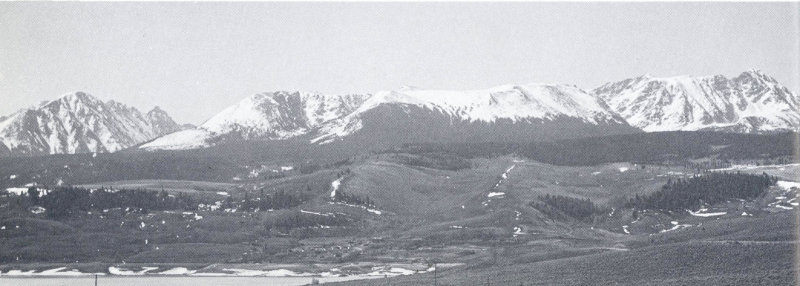
From clay to gold, much of Colorado’s wealth has come from her mountains. But after the rush to the mines, as veins were mined out and placers worked over, as values and prices changed, her population sought the riches of the prairies: fertile lands for agriculture, and in the rock layers below, black gold—vast accumulations of oil and natural gas. The tablelands and plateaus west of the mountains yield their wealth, too. Here are valley farms, fed often by irrigation water, and ranch country. Here is more oil, and in some areas precious metals and uranium.
In recent years Colorado’s prairies, peaks, and plateaus have brought new meaning to all America: the state now provides an attractive playground for state residents and their visitors. Campgrounds, streams, lakes, and high trails beckon in summer; barren slopes deep in winter snow attract the skier. More and more, those who live in Colorado and those who visit her seek to understand these mountains and hills and prairies, to learn of her geologic origins and her far distant past. For tourist and resident, casual visitor, ski enthusiast, Sunday picnicker, for all those who have met Colorado and enjoyed her, this book is written.
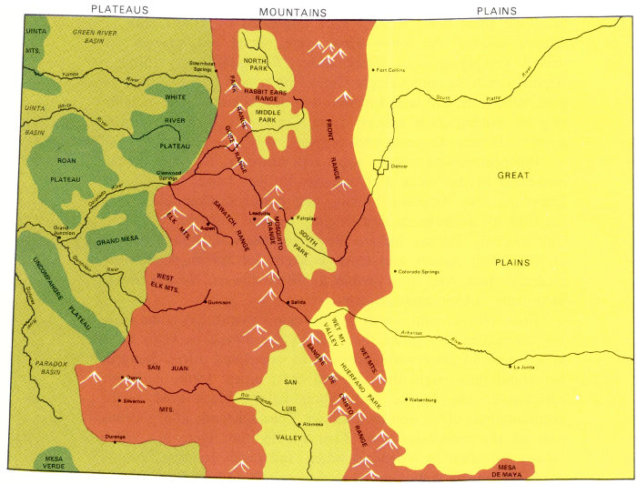
Topographically, scenically, and geologically, Colorado can be divided into the three provinces shown here.
- PLATEAUS
- UINTA MTS.
- GREEN RIVER BASIN
- Yampa River
- Steamboat Springs
- UINTA BASIN
- White River
- WHITE RIVER PLATEAU
- ROAN PLATEAU
- Glenwood Springs
- Colorado River
- Grand Junction
- GRAND MESA
- Gunnison River
- UNCOMPAHGRE PLATEAU
- Dolores River
- PARADOX BASIN
- MESA VERDE
- MOUNTAINS
- NORTH PARK
- RABIT EARS RANGE
- PARK RANGE
- MIDDLE PARK
- GORE RANGE
- FRONT RANGE
- ELK MTS.
- Aspen
- SAWATCH RANGE
- Leadville
- MOSQUITO RANGE
- Fairplay
- SOUTH PARK
- WEST ELK MTS.
- Gunnison
- Salida
- WET MTS.
- SANGRE DE CRISTO RANGE
- SAN LUIS VALLEY
- Rio Grande
- Alamosa
- SAN JUAN MTS.
- Ouray
- Silverton
- Durango
- MESA DE MAYA
- PLAINS
- Fort Collins
- South Platte River
- Denver
- GREAT PLAINS
- Colorado Springs
- Arkansas River
- WET MT. VALLEY
- HUERFANO PARK
- La Junta
- Walsenburg
I
Colorado’s Three Provinces
Scenically, Colorado is divided into three provinces: the Plains or Prairies on the east, the Rocky Mountains bisecting the state from north to south, and the Colorado Plateaus on the west. There are a number of local variations of course, but by and large the provinces are clearly defined. These three divisions will form the basis for our discussion of the geology of Colorado, for the scenic differences are almost exactly paralleled, and usually controlled, by differences in geologic structure.
The Plains rise gently from an elevation of about 3350 feet at the eastern border of the state to 5000 feet where they meet the mountains 150 miles further west.
Two major rivers cross the Colorado Plains: the South Platte River, flowing northeastward from the Denver region, and the Arkansas River, which leaves the mountains at Canon City south of Colorado Springs and travels eastward across the southern portion of the state. Tributaries of these two main river systems have etched the prairie surface, so that much of eastern Colorado has a gently rolling, hilly appearance.
The Mountains rise abruptly along a north-south line at about 105° west longitude. They reach elevations of over 14,000 feet at Pikes Peak, Mount Evans, Longs Peak (all visible from far out on the plains), and fifty other peaks further west. The ranges of the Colorado Rockies form rank upon rank of ridges and peaks, roughly north-south in trend, about 100 miles across from east to west, extending from the northern to the southern border of the state. Here, in mountain springs and lakes, are born the rivers of Colorado: the Platte, the Arkansas, the Yampa, the Colorado. Crags and cliffs tower above tree-covered slopes, the rocks always a dominant part of the landscape. The continental divide runs through the state along the summit ridges. West of the divide, all streams flow to the Colorado River and the Pacific; east of it, streams flow into the Mississippi or the Rio Grande, and thence to the Gulf of Mexico.
West of the highest ranges, the country flattens out once more into the Plateaus, which extend across western Colorado, southern Utah, and northern Arizona. Here, the predominant land forms are flat-topped mesas and deep canyons. Redrock walls shimmer in the brilliance of the western sun, offset by deep purple shadows 4 sometimes hiding ancient cliff dwellings. Fragrance of pine and juniper mingles with the pungency of sage. Narrow tracks lure the explorer. Despite the canyons, water is scarce except along major river systems, for this is the beginning of the desert west.
The scenic and geologic division of the state into three north-south strips is not everywhere clearly defined. In southwestern Colorado, the San Juan Mountains and the complicated uplifts surrounding Ouray and Silverton are out of key with either mountain or plateau. They are best considered part of the Mountain Province, however, although they extend it far to the west. Other exceptions to these divisions occur also. The Mountain Province is interrupted by four broad high-altitude valleys: North Park, Middle Park, South Park, and the San Luis Valley. The Uinta Mountains jut into the northwest corner of Colorado from adjacent Utah. And the Paradox, Uinta, and Green River Basins protrude into the Plateau Province, modifying its topographic character.
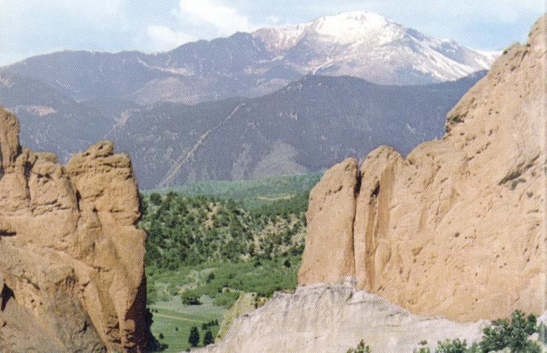
Pikes Peak rises to an elevation at 14,110 feet. Composed of Pikes Peak Granite, the mountain is almost surrounded by younger sedimentary rocks, including those of the Garden of the Gods, in the foreground. (Floyd Walters photo)
Before discussing the geologic nature of the three provinces, let us review briefly two sets of geologic terms. The first set has to do with the rocks themselves—What kind of rock is that?—but serves also to tell something about the origin of the rocks. The second set is concerned with time—When was that rock formed? Is it older or younger than adjacent rock? How does it relate, time-wise, to geologic events in other parts of the world?
These two sets of terms are presented in the charts that follow. If you are unfamiliar with geologic terminology, refer to these charts as often as you need to while you read this book, as well as to the glossary on pages 114-118.
Geologists divide rocks into three main groups, depending on their modes of origin.
Igneous rocks originate from molten material, cooling deep below the surface of the earth (intrusive igneous rocks) or flowing out and hardening at the surface (extrusive igneous rocks).
Sedimentary rocks are formed from broken or dissolved bits of other rock, washed by wind and water and deposited as layers of fragments or as chemical precipitates. They often contain fossil plants or animals.
Metamorphic rocks are pre-existing rocks (igneous or sedimentary) changed by heat, pressure, or chemical action.
Examples of these three classes of rocks are given in the accompanying figure. Many varieties of all three classes occur in Colorado.
| Class | Example | Occurrence in Colorado |
|---|---|---|
| Sedimentary | Sandstone | Plains, plateaus, flanks of mountain areas |
| Shale | ||
| Conglomerate | ||
| Limestone | ||
| Igneous | Extrusive: Basalt |
Volcanic areas such as San Juan Mountains, Spanish Peaks |
| Intrusive: Granite Diorite |
Pikes Peak, Longs Peak, and most central mountain areas | |
| Metamorphic | Marble (from limestone) | Mountain areas |
| Quartzite (from sandstone) | ||
| Gneiss (from granite or sandstone) | ||
| Schist (from shale or basalt) |
6Geologists arrange rocks in their chronologic sequence by studying the fossils and minerals which they contain. The age of some rocks can be determined with reasonable precision from ratios of radioactive minerals and their fission products. The relative age of others can be determined from their position, the fossils enclosed in them, and many minor details of their structure.
The stratigraphic column shown opposite may be thought of as a calendar by which geologic events in Colorado can be arranged in their proper order and related to events in the rest of the world. Mississippian and Pennsylvanian Periods are American divisions; elsewhere this time interval is known as the Carboniferous Period. Other time terms are in worldwide use.
In the generalized geologic map of Colorado which accompanies Chapter II, rocks are identified by the era in which they were formed. A more detailed geologic map can be obtained from the U.S. Geologic Survey map distribution center in the Federal Building, Denver.
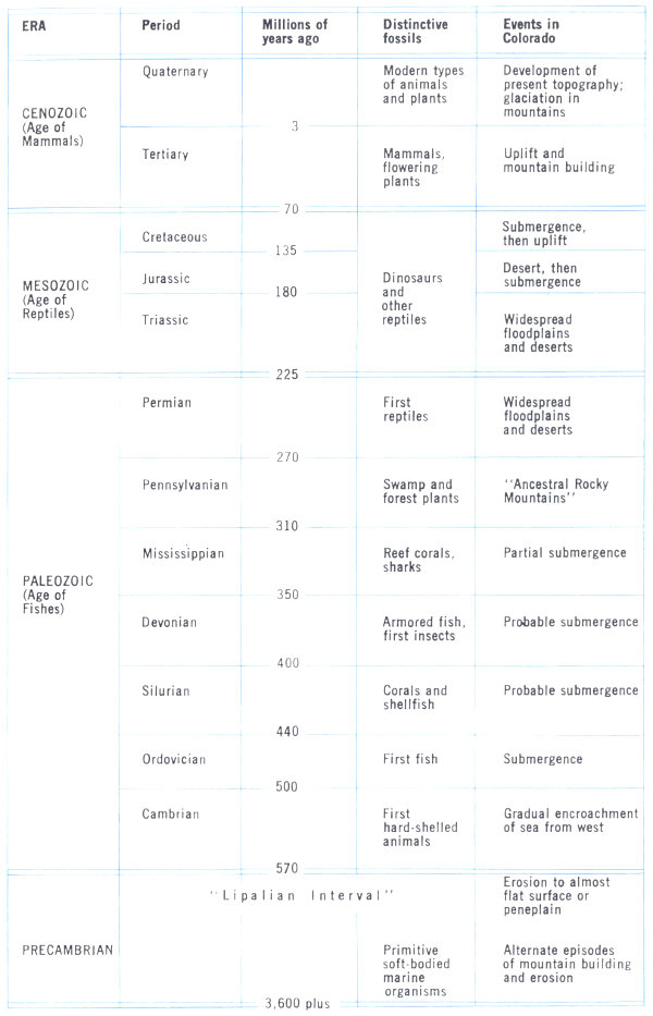
Stratigraphic Column
| ERA Period | Millions of years ago | Distinctive fossils | Events in Colorado |
|---|---|---|---|
| CENOZOIC | |||
| (Age of Mammals) | |||
| Quaternary | Modern types of animals and plants | Development of present topography; glaciation in mountains | |
| 3 | |||
| Tertiary | Mammals, flowering plants | Uplift and mountain building | |
| 70 | |||
| MESOZOIC (Age of Reptiles) |
Dinosaurs and other reptiles | ||
| Cretaceous | Submergence, then uplift | ||
| 135 | |||
| Jurassic | Desert, then submergence | ||
| 180 | |||
| Triassic | Widespread floodplains and deserts | ||
| 225 | |||
| PALEOZOIC | |||
| (Age of Fishes) | |||
| Permian | First reptiles | Widespread floodplains and deserts | |
| 270 | |||
| Pennsylvanian | Swamp and forest plants | “Ancestral Rocky Mountains” | |
| 310 | |||
| Mississippian | Reef corals, sharks | Partial submergence | |
| 350 | |||
| Devonian | Armored fish, first insects | Probable submergence | |
| 400 | |||
| Silurian | Corals and shellfish | Probable submergence | |
| 440 | |||
| Ordovician | First fish | Submergence | |
| 500 | |||
| Cambrian | First hard-shelled animals | Gradual encroachment of sea from west | |
| 570 | |||
| PRECAMBRIAN | “Lipalian Interval” | Erosion to almost flat surface or peneplain | |
| Primitive soft-bodied marine organisms | Alternate episodes of mountain building and erosion | ||
| 3,600 plus | |||
THE PRAIRIES
Beneath the flat prairies of eastern Colorado, sedimentary rocks form a series of layers. Those near the surface are among the youngest rocks in Colorado. We know this from the fossils they bear, fossils of large mammals such as the hairy mammoth, which lived in early Quaternary time, the bison, and many smaller mammals living today.
The layers below—sandstones, shales, and limestones—become progressively older as one goes deeper. Most of them were formed originally on the bottoms of shallow seas that covered this part of North America several times during the history of the continent. In most places the layers are horizontal or nearly so, but westward, as they approach the mountains, they bend upward, gently at first and then more steeply. At the very edge of the mountains, where they were dragged upward when the mountains rose, their eroded edges appear at the surface.
The entire sequence of flat-lying rocks can be studied where they are exposed along the mountain front or where streams and rivers have dissected them. They are also known from cuttings and cores of oil and water wells. Some parts of Colorado’s eastern plains have been drilled so intensively in the search for oil and gas that we know a great deal about the subsurface sedimentary rock and can even make maps showing the distribution and character of the individual rock layers. From such maps, the history of the region can be deduced. We know, for example, that the area around Denver has subsided more in the past than has the area near La Junta or Lamar; it is called the Denver Basin because of its past history and not because it is a basin at present.
Although the plains of Colorado appear flat, they really slope gently eastward. The rock layers near the surface slope eastward also, but the deeper rock layers may not.
Near the western edge of the Plains Province, hills and valleys are formed by differential erosion of hard and soft rock layers. Some hills, such as Castle Rock, are topped with resistant sandstone; others, like Mesa de Maya south of Trinidad and Table Mountain near Golden, are capped with layers of basalt. Close to the mountains flat-topped foothills result from partial dissection of former erosion surfaces as the mountains, stabilized for a time, rose again, or as climatic cycles changed. Examples of these dissected erosion surfaces can be seen north and south of Boulder.
Far east of the mountain front, near the northern border of 9 Colorado, remnants of another, higher prairie surface stand as Pawnee Buttes. Torrential erosion—spring floods and summer thunderstorms—has deeply furrowed the prairie surface here and left these buttes as lonely sentinels.
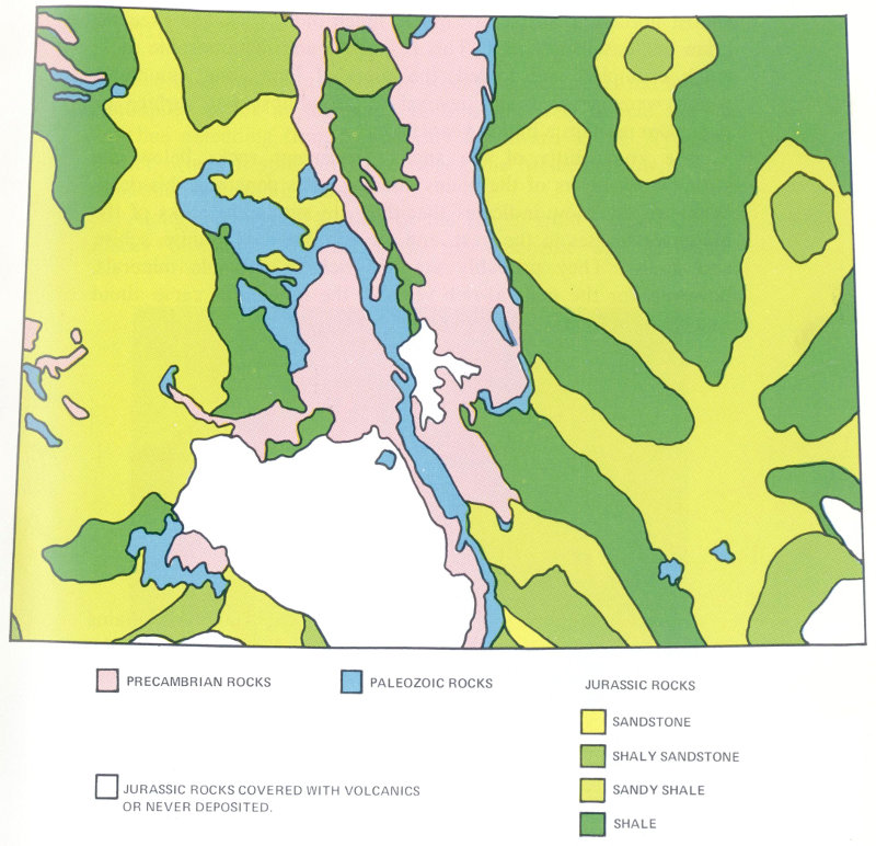
This map shows the distribution, character, and thickness of certain Jurassic rocks in Colorado. These rocks are deeply buried beneath the plains and are known there only from well samples. They have been eroded from most mountain areas. They come to the surface along the edges of the mountains and in the deeply incised canyons of the Plateau Province.
- PRECAMBRIAN ROCKS
- PALEOZOIC ROCKS
- JURASSIC ROCKS
- SANDSTONE
- SHALY SANDSTONE
- SANDY SHALE
- SHALE
- JURASSIC ROCKS COVERED WITH VOLCANICS OR NEVER DEPOSITED.
What lies below the sedimentary layers of the plains? The sedimentary rocks are 5,000 to 10,000 feet thick. They lie on an 10 almost horizontal surface of much, much older rock, the Precambrian or “basement” rock. This is igneous and metamorphic rock, much crumpled and folded, the roots of long gone mountains which were beveled and leveled to an almost flat surface or peneplain perhaps a billion years ago.
We know little of the ancient basement rocks below the sedimentary layers of the plains, for few wells penetrate this deep. What we do know indicates that they are similar to rocks of the mountain masses to the west, and are composed of granite, schist, and gneiss. They probably are not rich in valuable minerals, however, for the mineral-rich veins of the mountains came about as a result of uplift of the mountain areas.
THE PEAKS
Most of the individual ranges making up the Rocky Mountains in Colorado are the result of highly localized movements of the crust as the entire region was thrust upward from below. These movements broke the deep, massive igneous and metamorphic rocks of the Precambrian basement, and bent the more flexible Paleozoic and Mesozoic layered rocks above them until they arched upward in a series of corrugations. The mountains thus formed are known to geologists as faulted anticlines.
As the mountains rose, they were of course attacked by the forces of erosion. The sedimentary layers were completely stripped from the crests of many of the uplifts, so that Precambrian rocks were exposed. It is these rocks which form the summits of the highest peaks of Colorado. As with all rules, there are exceptions: the Spanish Peaks are volcanic, and the crest of the Sangre de Cristo Range is composed of sedimentary rocks.
The trend of most of the ranges in Colorado is north-south, swinging to northwest-southeast near the southern end. Surprisingly, in the northwestern corner of the state there is an east-west trending range, the Uinta Mountains.
Fifty or more mountain ridges in Colorado have been named as separate ranges. Of these, the most prominent, frequently visited ones will be discussed here.
Front Range
The easternmost range of the Rocky Mountains is the longest continuous uplift in the state. It is a relatively simple faulted anticline extending from Canon City northward to the Wyoming border, where it splits into two ridges, the Medicine Bow Mountains and the Laramie Range.
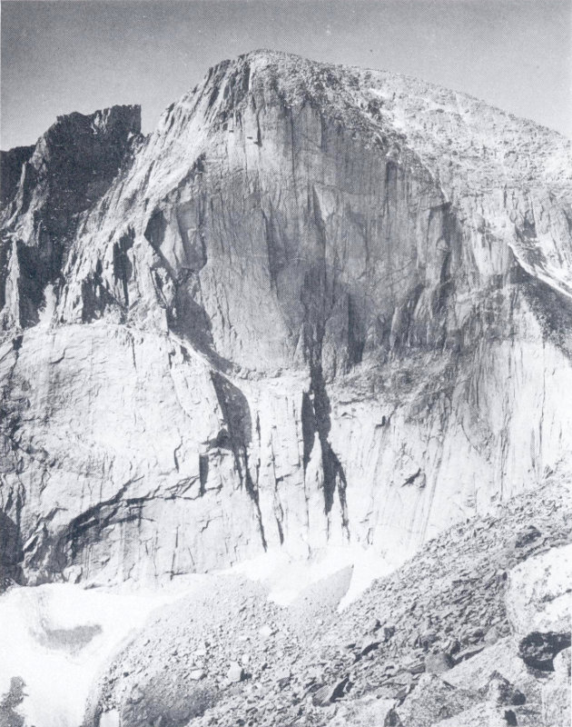
Longs Peak challenges technical climbers with its 2000-foot vertical east face, the Diamond. This magnificent cliff is the result of glacial action and freezing and thawing in homogeneous but fractured granite. The small remnant of ice and snow at the lower left is all that remains of the glacier. The flat summit may be part of an ancient erosion surface formed toward the end of Precambrian time. (Jack Rathbone photo)
Along the highest portion of the range, from Pikes Peak to Rocky Mountain National Park, the Paleozoic and Mesozoic 12 sediments formerly draped over the top of the range have long since been washed away, leaving only the gneiss, granite, and schist of the mountain core. The almost flat tops of Longs Peak, Mt. Evans, and Pikes Peak, and the rolling upland traversed by Trail Ridge Road in Rocky Mountain National Park are thought to be remnants of the 600-million-year-old erosion surface that once existed at the top of the Precambrian rocks, and that still exists below the sedimentary rocks of the Plains Province. This surface, formed near sea level, has been raised 12,000 to 14,000 feet within the Mountain Province.
Throughout most of its length, the Front Range displays some of the most striking high-altitude scenery in the world. Particularly accessible areas, well worthy of visits, are Rocky Mountain National Park, Berthoud and Loveland Passes, Mt. Evans, and Pikes Peak. In these areas the Precambrian rocks can be seen and studied, and the effects of glaciation observed.
The granite, gneiss, and schist of the mountain core are shattered and broken into blocks of various sizes. The breaks between the blocks are called joints if there is no apparent displacement between adjacent blocks, and faults where there is obvious displacement. The joints frequently appear in parallel arrays or sets; there may be two or more intersecting sets, giving a cross-hatched appearance to large exposures.
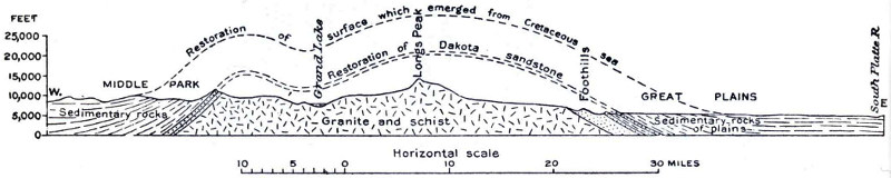
East-west profile across Rocky Mountain National Park, through Grand Lake and Longs Peak, showing the inferred position of the original surface of the anticlinal uplift of the Front Range. This diagram is generalized, and faults are not shown. (USGS Bull. 730a)
- Restoration of surface which emerged from Cretaceous sea
- Restoration of Dakota sandstone
- MIDDLE PARK
- Grand Lake
- Longs Peak
- Foothills
- GREAT PLAINS
- Sedimentary rocks
- Granite and schist
- Sedimentary rock of plains
- South Platte R.
Big Thompson Canyon, west of Loveland on U.S. highway 34, is carved in almost vertical layers of Precambrian metamorphic rocks. Gently dipping Late Paleozoic and Mesozoic sedimentary rocks of the Fountain, Lyons, Lykins, and Morrison Formations can be seen in the distance, capped by the Cretaceous Dakota Sandstone. (Floyd Walters photo)
The Precambrian rocks vary from place to place. Several irregular masses of granite, called batholiths, make up portions of the range. Batholiths are large intrusions of molten rock that cooled slowly at great depth. The minerals in them form distinct crystals, often quite large. The Pikes Peak Granite and the Boulder Creek Granite are examples. Highly contorted and banded gneiss and schist are well exposed elsewhere, particularly in the Idaho Springs-Central City-Black Hawk region.
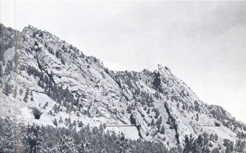
Along the flanks of the Front Range, the eroded edges of the sedimentary rocks which once covered the range are exposed. These rocks are usually tilted sharply against the mountains, as at Garden of the Gods, Denver’s Red Rocks Park, and the Flatirons near Boulder. The Rocky Mountain Association of Geologists has erected a plaque explaining the geology of the Red Rocks area; look for it about half a mile northeast of the Red Rocks Amphitheater. Tilted layers of Paleozoic and Mesozoic sandstones form hogback ridges along the mountain front, and stand out clearly on aerial photographs.
In some areas, particularly near Boulder, Coal Creek, and Golden, the tilting of the sedimentary layers has been so extreme that the layers are upside down. Basement rocks may even be thrust out above them.
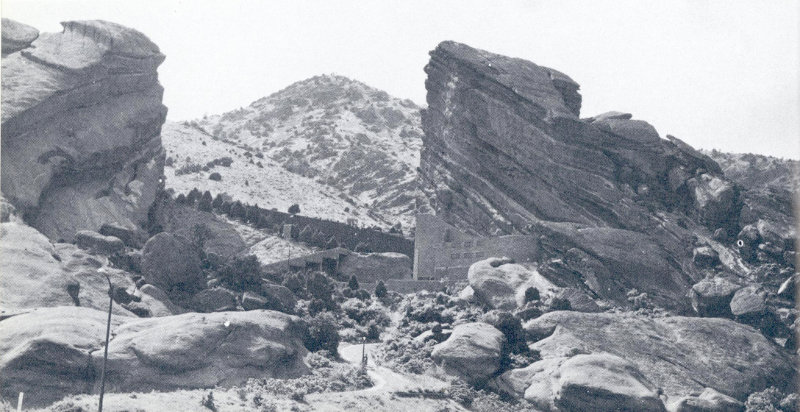
Sandstones and conglomerates of the Pennsylvanian Fountain Formation dip steeply toward the plains along the eastern edge of the Rockies. Near Denver, erosion has carved these rocks into a natural amphitheater, now the site of Red Rocks Amphitheater. Precambrian granite forms the hill in the background. (Jack Rathbone photo)
Further north, near Loveland and Lyons, as well as further south at Colorado Springs, irregularities in the uplift have caused abrupt breaks in the generally smooth eastern edge of the range. Folds and faults in these areas trend northwest, cutting across and offsetting the mountain front.
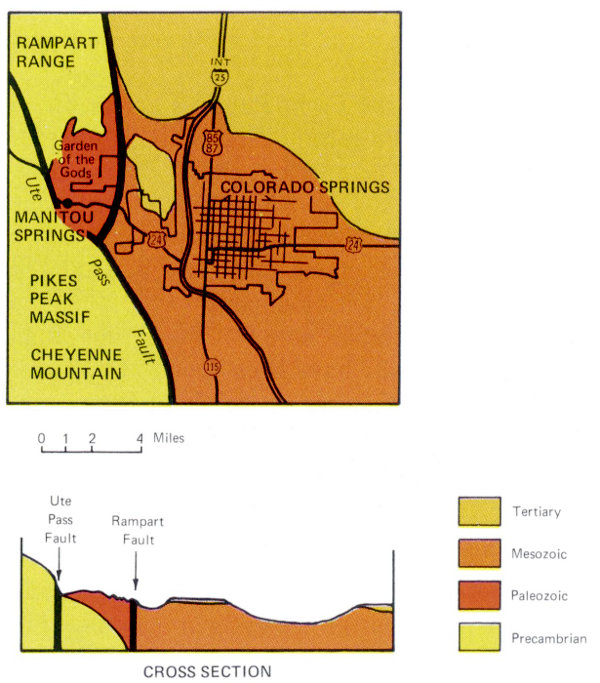
South of Colorado Springs, between Fort Carson and the NORAD installation in Cheyenne Mountain, Mesozoic rocks are faulted against the mountain front. Paleozoic rocks are deeply covered by as much as 3000 feet of Mesozoic sediments. They come to the surface about 10 miles further south.
- RAMPART RANGE
- Garden of the Gods
- Ute Pass Fault
- MANITOU SPRINGS
- PIKES PEAK MASSIF
- CHEYENNE MOUNTAIN
- COLORADO SPRINGS
- CROSS SECTION
- Ute Pass Fault
- Rampart Fault
- Tertiary
- Mesozoic
- Paleozoic
- Precambrian
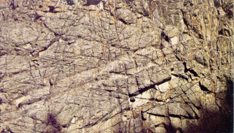
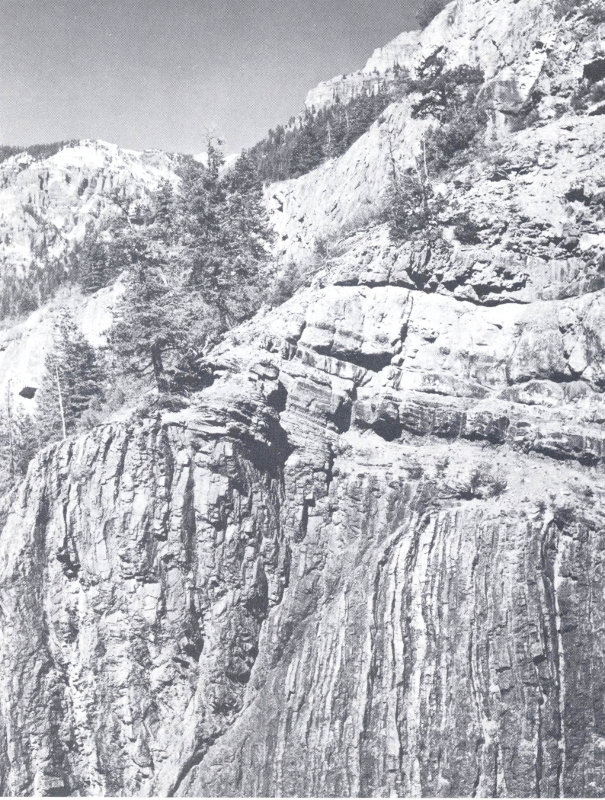
West of Boulder, several intersecting sets of joints pattern the Precambrian rocks above Boulder Creek. (John Chronic photo)
The west margin of the Front Range is not as sharply defined as the eastern margin. Prominent faults edge North, Middle, and South Parks, however. The northern end of the range merges with the Medicine Bow Mountains, where dips of sedimentary rocks seldom exceed 30 to 40 degrees. At its southern end, the Front Range plunges into the plains, although a southwest-trending ridge connects it with the Wet Mountains.
Within the Precambrian core of the Front Range, many economic mineral deposits have been found. These are discussed in Chapter III. Glacial features of the Front Range are discussed in Chapter II in the section on the Quaternary Period.
Wet Mountains
The Wet Mountains are the easternmost range of the Rockies south of Canon City. Their crest has a distinct northwest-southeast trend, with the north end offset about 25 miles westward from the south end of the Front Range. The Canon City Embayment lies at the junction between the ranges.
Though smaller and lower than the Front Range, the Wet Mountains include many pleasant and easily accessible recreation areas and a number of attractive streams and reservoirs. Greenhorn Peak, the summit of the range, is 12,334 feet high. It is formed of Precambrian granite, as is most of the crest of the range.
The structure of the eastern side of the Wet Mountains is similar to that of the Front Range, except that there are more faults in the sedimentary layers. The southern end plunges southeastward into the plains. On the western side, westward-dipping sediments are completely submerged in Cenozoic lava flows and debris from the mountains. Ore minerals very like those of the Front Range occur near Silver Cliff, but they have so far proved to be of little economic importance.
Sangre de Cristo Range and Spanish Peaks
The Sangre de Cristo Mountains are visible from many parts of southeastern Colorado as a jagged, sawtoothed, snow-crested ridge on the western skyline. They extend about 150 miles from the Arkansas River near Salida southward into New Mexico.
Few mountain ranges form so impassable a barrier as the Sangre de Cristos. Only at La Veta Pass does a highway cross the range. However, old wagon roads, passable now by jeep or on foot, once existed across Hayden, Music, Mosca, and Whiskey Creek Passes.
Often no more than twenty miles wide, the central portion of the range is composed largely of red Late Paleozoic sediments like those exposed in the Garden of the Gods and Red Rocks Park. These rocks are intricately folded and faulted, but not metamorphosed. They include sandstones, shale, conglomerates, and fossil-bearing limestones. The northern end of the range is formed of Precambrian igneous and metamorphic rocks.
Just west of La Veta Pass, Sierra Blanca stands as an outpost of the range where its continuity is interrupted and its structure changed. Huge blocks of Precambrian granite were here pushed upward and thrust westward to form a cluster of peaks, several of which are over 14,000 feet in elevation.
Many prominent rock glaciers are present in the Sangre de Cristo Mountains. They are composed of fragments of rock, lubricated by snow and ice, creeping almost imperceptibly down the steep flanks of the high peaks. One of these rock glaciers can be seen on the slope of Mt. Mestas east of La Veta Pass; others are visible from Great Sand Dunes National Monument.
South of La Veta Pass, an igneous intrusion along the axis of the range changes the character of the Sangre de Cristos. This intrusion is harder and has weathered more slowly than the rest of the range, and forms a group of prominent peaks known as the Culebra Range.
On the west flank of the Sangre de Cristo Range, east of Villa Grove, a prominent iron-mineralized area can be seen. Here the ghost mine of Orient marks the site where iron ores were mined in the early days of the Colorado Fuel and Iron Company. Nearby, an abrupt terrace along the edge of the valley marks the position of a fault. Recent gravels are involved in this fault, indicating that movement has taken place here within the last few hundred years. A number of hot springs occur along the base of the mountains nearby.
The Spanish Peaks, not structurally related to the Sangre de Cristos, are visible from La Veta Pass highway. These two peaks represent a pair of Cenozoic volcanoes, now deeply eroded and much reduced from their former height. Numerous dikes radiating from the bases of these peaks represent fissures which were filled with lava as the peaks formed.
The Great Sand Dunes, close to the Sangre de Cristo Mountains north of Sierra Blanca, are discussed in Chapter II in the section on the Quaternary Period.
Spanish Peaks, south of Colorado Springs and southwest of Walsenburg, are twin mountains of volcanic and intrusive rock, the roots of Tertiary volcanoes greatly worn down and reshaped by erosion. This view looks southeast from near La Veta Pass, on U.S. Highway 160. (Jack Rathbone photo)
Park Range and Rabbit Ears Range
Bordering the western side of North, Middle, and South Parks, another long north-south trending ridge extends from the Wyoming border toward the center of Colorado. The northern part of this ridge, forming the western boundary of the main mountain mass in the state, is called the Park Range.
The structure of the Park Range is similar to that of the Front Range: a huge linear corrugation in the earth’s crust, bounded by faults. Because this area has fewer resistant sedimentary rock layers above the Precambrian basement rocks, it is not prominently edged with upturned sedimentary layers.
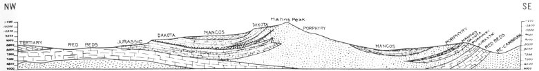
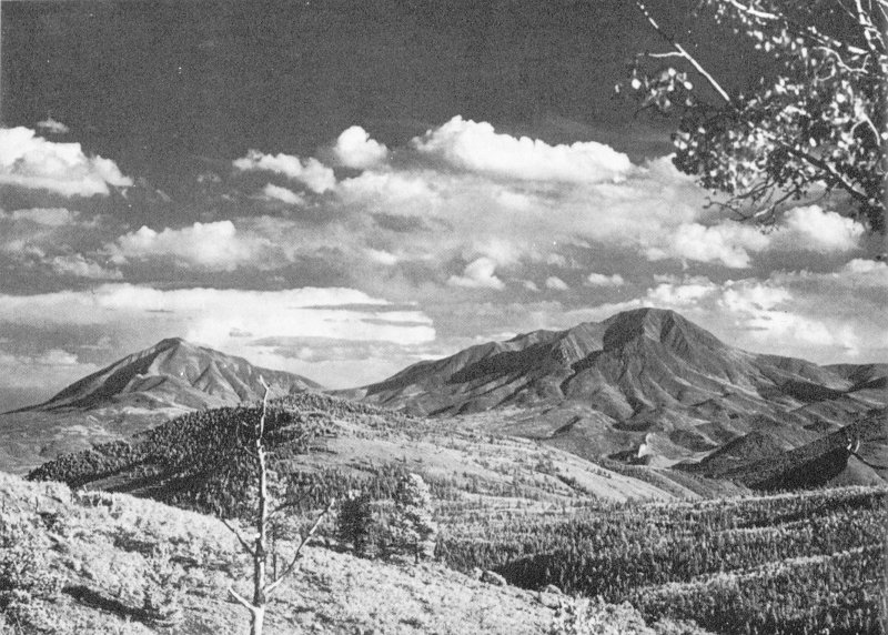
Hahn’s Peak, a highly eroded laccolith of rhyolite porphyry, lies on the west side of the Park Range, along the eastern margin of the Plateau Province. Placer gold was discovered here in 1865, but the bedrock source of the gold was never found. (Jack Rathbone photo) A geologic section shows the structure of the area.
- TERTIARY
- RED BEDS
- JURASSIC
- DAKOTA
- MANCOS
- DAKOTA
- Hahn’s Peak
- PORPHYRY
- MANCOS
- DAKOTA
- PORPHYRY
- JURASSIC
- RED BEDS
- RE-CAMBRIAN
The range is crossed by Rabbit Ears Pass in the north; Gore Pass near Kremmling marks its southern end. Mt. Zirkel (12,180 feet) and Flattop Mountain (12,118 feet) are the two high points 20 of the range; these and a number of unnamed peaks over 11,000 feet high are upward-faulted blocks of Precambrian granite.
A rough ridge of volcanic country joins the Park Range with the Front Range and effectively separates North Park and Middle Park. This is the Rabbit Ears Range, named for a double-eared knob of Precambrian granite near Rabbit Ears Pass on U. S. highway 40. Many Tertiary volcanic features, including dikes and lava flows, can be seen along this ridge, which is also traversed by Colorado state highway 125 between Granby and Walden via Willow Creek Pass.
Gore Range
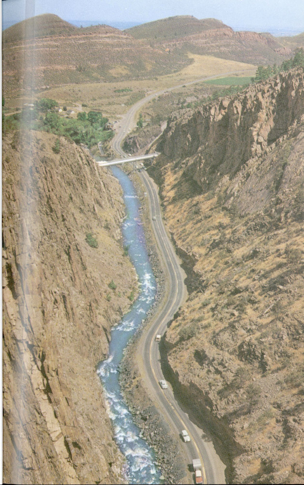
The Gore Range lies south of Gore Pass, along the Park Range trend. The ridge of this range is low for about 15 miles south of Kremmling, but the southern part of the range forms a spectacular high cluster of peaks with many relatively inaccessible and rugged summits. Many of the peaks in this remote country are as yet unnamed; the area has been set aside as the Gore Range-Eagle’s Nest Wilderness Area. The Colorado River cuts directly across the northern part of the Gore Range just west of Kremmling, in a steep-walled canyon that is one of the wild scenic spots of Colorado.
The southern part of the Gore Range, viewed from the east, shows Precambrian granite and metamorphic rocks rising above Cretaceous shale hills. The nearly horizontal crest of the range probably represents the Precambrian erosion surface. (Jack Rathbone photo)
The Gore Range is, like the Front Range, a faulted anticline with Precambrian rocks at its core. The red sedimentary rocks on the west flank of the range, visible at Vail Pass and Vail ski area, are of the same age as those in Red Rocks Park near Denver and the Garden of the Gods near Colorado Springs. Paleozoic rocks are absent on the east flank of the range, having been eroded 21 from that area before Mesozoic deposition. South of the Colorado River and north of the Wilderness Area, Mesozoic rocks extend over the crest of the range.
The south end of the Gore Range is marked by Tenmile Gorge (U. S. highway 6 between Frisco and Vail Pass). This gorge is a glacial valley, carved during the Ice Age by a glacier more than 1,000 feet thick, along a weak faulted zone in the range. A fault surface can be seen on the east side of the valley.
From Vail Pass, or from the top of the Vail ski lift, other evidences of glaciation can be seen—cirques and U-shaped valleys—testifying to the former presence here of many large valley glaciers.
Tenmile and Mosquito Ranges
With scarcely a break, the Park Range-Gore Range structure continues southward into the Tenmile and Mosquito Ranges. These high ridges separate South Park from the upper Arkansas Valley, and include a cluster of very high peaks, Quandary, Mt. Lincoln, Mt. Democrat, and Mt. Bross, all over 14,000 feet in elevation.
Structurally, both the Tenmile Range and the Mosquito Range are highly asymmetrical anticlines, gentle on the east and steeply faulted on the west. Paleozoic sedimentary rock layers containing many fossils cover large portions of the higher parts of these ranges, but two of the highest peaks, Mt. Bross and Mt. Lincoln, are capped by the Lincoln Porphyry, a Tertiary intrusive, while Quandary Peak is Precambrian granite.
These mountains are highly mineralized, and have been extensively explored and mined. The Climax Molybdenum Corporation operates an especially large mine at Climax, and the New Jersey Zinc Company has a large underground mine and mill at Gilman, on the western slopes of Tenmile Range.
Buffalo Peaks, two highly eroded volcanic mountains near the south end of Mosquito Range, are extrusions of lava and ash which have buried the axis of the Mosquito uplift. They are major volcanoes related to a group of small volcanic cones near Antero Junction, in South Park.
South of Buffalo Peaks, near Trout Creek Pass, the Mosquito Range loses altitude rapidly and merges with the rough country called the Arkansas Hills. Cinder cones, dikes, and other evidences of Tertiary volcanic activity can be seen between Trout Creek Pass and Salida.
Sawatch Range
Bordering the Arkansas River valley on the west, the Sawatch Range includes Colorado’s highest mountain, Mt. Elbert (14,417 feet). With several other 14,000-foot summits, this range is the highest in the state. One group of peaks, known as the Collegiate Range (Mts. Harvard, Yale, Columbia, and Princeton) forms a particularly imposing vista from U. S. highway 24 between Trout Creek Pass and Buena Vista. The Independence Pass highway (Colorado 82) between Leadville and Aspen penetrates the heart of the Sawatch high country.
The Sawatch Range as a whole is about 100 miles long (north to south) and 40 miles wide. It is a great faulted anticline intruded by igneous rocks. The high area north of Leadville shows that the Sawatch and Mosquito Ranges are in reality one huge dome with a slight sag in the middle. The ranges, though, are sharply separated topographically by the deep valley of the Arkansas River. Precambrian rocks are near the surface between the ranges, hidden only by a thin cover of stream gravels. Near Leadville, some complexly faulted Paleozoic limestones lie in the sag between the ranges.
At Mt. Princeton Hot Springs there is evidence of repeated faulting and igneous activity. The rocks are strongly altered by hot water coming to the surface through fissures and cracks.
On the west side of the Sawatch range, the old mining towns of Tincup and Aspen grew up where limestone and sandstone layers, broken and crumpled as the Sawatch Range rose, were mineralized by solutions rich in gold and silver. The Aspen Mining District was studied extensively by geologists of the U.S. Geological Survey, and their maps show almost unbelievable complexity in the faulting of the rock layers which exist there.
The north end of the Sawatch Range plunges under shales and sandstones along the Eagle River east of Wolcott. Gypsum in the sediments here has acted like putty: the layers of rock in which it was deposited have become peculiarly crumpled, making the area along the Eagle River (visible from U. S. Interstate 70) between Avon and Edwards hummocky and irregular. Vegetation is unusually sparse here because of gypsum in the soil.
About midway between Edwards and Wolcott, the Eagle River suddenly changes direction and flows northward for about a mile before resuming its former westward course. This sudden change is caused by a sharp north-south fold in the sedimentary rocks on the northwestern flank of the Sawatch Range. A magnificent series of roadcut and hillside exposures along the highway 23 here illustrates the close relation between rock layers and river course. Within about a mile, the highway cuts through rocks of Pennsylanian, Permian, Triassic, Jurassic, and Cretaceous age, spanning a geologic time interval of more than 200 million years.
The south end of the Sawatch Range, at Monarch Pass, contains steeply dipping Late Paleozoic limestones and coal beds. The coal has been mined on a small scale; the limestone is now quarried for use as a flux in iron smelters at Pueblo.
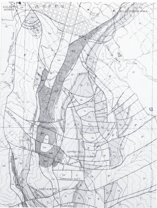
The area below the Aspen Mountain ski lift is highly complex geologically. It is particularly well known because of extensive prospecting and mining activity in the region.
Elk Mountains and West Elk Mountains
The Elk Mountains and West Elk Mountains appear to be westward continuations of the Sawatch Range. Structurally, however, they are not faulted anticlines like most of the other ranges in Colorado, but are composed of a series of layers of Paleozoic sediments thrust westward over one another. These rocks, often crumpled and highly metamorphosed, are cut by numerous sills, dikes, and other intrusions, many of which have caused mineral enrichment locally.
At Maroon Bells, in the canyon of Maroon Creek, and at Redstone on the Crystal River, these metamorphosed sediments are well exposed. Here, red sandstones and shales have been altered to quartzites and slate. At Marble, metamorphism of a thick limestone bed has produced white marble of great beauty, known as Yule Marble. This decorative stone was quarried extensively until about 1940. It was used in the Lincoln Memorial and several other monumental structures; in the town of Marble it has been used for the doorsteps of log cabins! The largest block quarried, for the Tomb of the Unknown Soldier in Arlington National Cemetery, measured 14 by 7.4 by 6 feet in the rough, and weighed 56 tons.
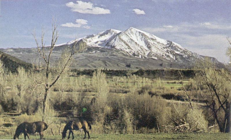
Mt. Sopris, south of Glenwood Springs, is an igneous intrusion. (Jack Rathbone photo)
Crested Butte, at the south end of the Elk Mountains, is a small intrusive igneous mass called a laccolith. Hard and resistant to erosion, it stands over 2,000 feet above the adjacent valley floor.
San Juan Mountains
The San Juan Mountains are the most extensive range in Colorado, and also the most heterogeneous. Covering more than 10,000 square miles of the southwestern part of the state, these mountains are formed mostly of Tertiary volcanic rocks, the result of repeated outpourings of lava and ash from a cluster of volcanoes. Water-laid gravels composed of volcanic sand and pebbles are interlayered with basalts and ash beds; the total thickness of these beds reaches many thousands of feet.
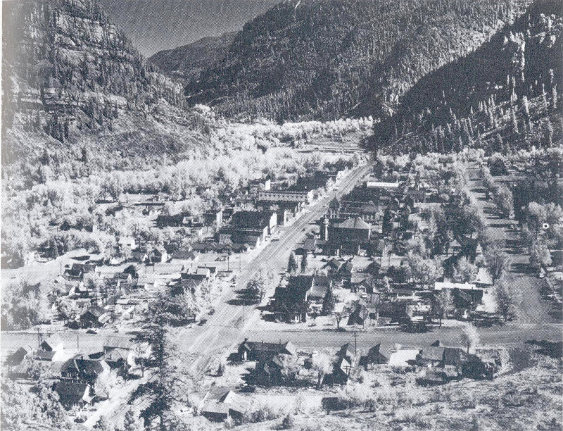
The mining town of Ouray, now also a tourist haven and summer resort, nestles below Pennsylvanian sedimentary rocks of Ouray Canyon. At the north end at town can be seen the Ouray Hot Springs swimming pool. Gold, silver, lead, and zinc are still mined in this area. (Jack Rathbone photo)
The widespread volcanic activity which formed most of the range began in mid-Tertiary time and continued for several million years. A few Quaternary volcanic flows are known in the region, but there is no active volcanism there at present.
The western side of the main range, including some of the highest peaks, consists primarily of uplifted and faulted Paleozoic sedimentary layers. These layers, highly dissected by erosion, can be seen near Ouray, at Molas Lake, and at Durango. Large 26 patches of Precambrian granite and metamorphic rocks protrude through the sediments, as in the Needle Mountains; they indicate that this part of the range is a faulted anticline like many other Colorado ranges.
Early Cenozoic glacial deposits occur in some parts of the San Juans. These are unusual features, as glaciation of this age is unknown elsewhere in Colorado.
Three small ranges rise just west of the San Juans: the San Miguel, Rico, and La Plata Mountains. Each consists of several small masses of Tertiary igneous rock intruded into Paleozoic conglomerates, shales, and limestones.
Mineralization has been intense in the San Juans; most of it took place during the Late Tertiary volcanic period. Rich veins penetrate Precambrian gneiss and granite, and Paleozoic limestones are often enriched also. Several mines are still active near Ouray, Silverton, Telluride, and Rico.
Uinta Mountains
The eastern end of Utah’s Uinta Mountains extends into Colorado. Unlike other ranges in Colorado, these mountains trend east-west. Structurally, the range is a faulted anticline. It is quite asymmetrical, however, and is tilted and folded upward on the south, and overturned or thrust-faulted on the north. Steeply dipping Mesozoic and Paleozoic sediments on the south side of the range, sparsely vegetated and often thrown into spectacular folds, are a prominent feature of northwest Colorado scenery.
In Colorado the crest of the Uintas reaches an elevation of about 8,500 feet. It consists of Precambrian rocks, but these are not the igneous and metamorphic rocks that characterize the Precambrian core of other Colorado mountains. They are easily recognized as sediments—dark red conglomerates, sandstones, and mudstones—virtually unmetamorphosed though they were deposited nearly a billion years ago. Called the Uinta Mountain Formation, these rocks are found only in this part of Colorado and adjacent areas of Utah. They are probably related to similar Precambrian rocks found in Montana and Canada.
At the east end of the Uintas two isolated uplifts, Cross Mountain and Juniper Mountain, are faulted blocks of Paleozoic rocks standing like islands in a sea of Cenozoic valley fill. They 27 are the last outposts of the Uinta anticlinal pattern as it wanes toward the southeast.
Dinosaur National Monument, a Uinta Mountain tourist attraction, encompasses a vast area of wilderness on both sides of the Yampa River in Colorado. Here many of the features of the east end of the Uinta Mountain structure can be seen. A unique display of the world’s largest fossils can be visited in the Utah portion of the Monument.
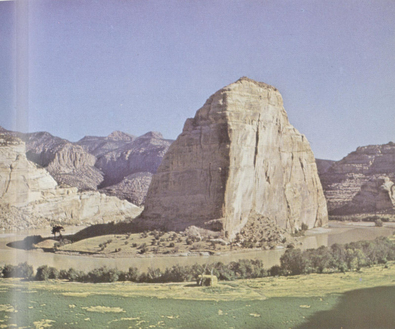
At their confluence in Dinosaur National Monument, the Yampa and Green Rivers have carved Late Paleozoic sandstone into the precipitous cliffs of Steamboat Rock. (William C. Bradley photo)
THE PLATEAUS
The western quarter of Colorado is a region of flat-lying Paleozoic, Mesozoic, and Cenozoic sedimentary rocks which have not been bent up into mountains except in a few isolated instances. This area lies more than a mile above sea level, however, and because of the gradient such an elevation affords, it is deeply sculptured. The Colorado River and its tributaries have sliced into the plateau surface, separating it into many isolated tablelands or mesas. Some are capped with sedimentary rock, others with Tertiary basalt.
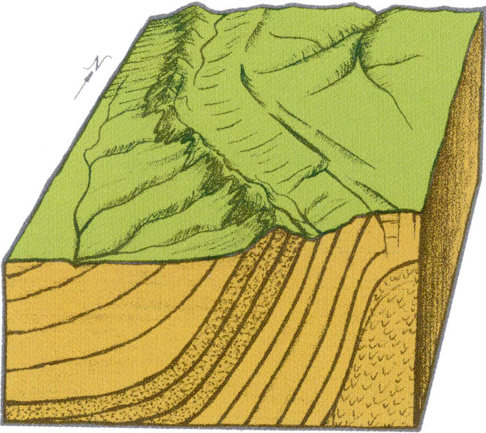
The Grand Hogback is a good example of the type of geologic structure known as a monocline. The hogback ridge is formed by differential erosion, where soft layers wear away more easily than hard layers.
Simple folds and faults have given the mesas different elevations. Thus the average elevation of the White River Plateau is 11,000 feet, that of the Roan Plateau 9,500 feet, and that of Mesa Verde only 7,000 feet. West of Durango the plateaus dip gently southward, as can be seen at Mesa Verde. Igneous intrusions and extrusions have altered plateau topography in some 29 areas. West of Mesa Verde, for instance, an intrusive stock forms a prominent dome in the Southern Ute Indian Reservation.
West of the northern Colorado mountains, and north and west of the White River Plateau, a rolling upland extends from Colorado into Utah and Wyoming. It is interrupted by the Uinta Mountains and a number of smaller related uplifts such as Juniper Mountain and Cross Mountain. South of the Uinta axis the area is known as the Uinta Basin.
The northern part of this area is structurally the south edge of the Green River or Washakie Basin in Wyoming. The Rangely anticline, in the northeastern corner of the Uinta Basin, is one of Colorado’s richest oil fields; it is discussed in Chapter III.
Although surfaced with much younger sediments than the rest of the Plateau Province, this area is structurally similar. On the whole, sedimentary layers are relatively flat-lying, and where they are uplifted they are deeply sculptured by streams and rivers. The sedimentary rocks in this region contain uranium and placer gold in addition to great oil and gas deposits. The southeastern part of the Uinta Basin, usually called the Piceance Basin, is the site of a great deposit of oil shale (see Chapter III). The term “basin” may here seem unusual to the casual observer, for the oil shales occur on the Roan Plateau at places well over 10,000 feet in elevation. However, the entire region was basin-like—lower than the surrounding ranges—for many millions of years, and during Tertiary time thousands of feet of valley and lake deposits were laid down in it.
The White River Plateau, north of Glenwood Springs, is composed of almost horizontal Paleozoic sedimentary rocks that fold downward sharply along its south and west edges. The fold is 135 miles long and is clearly marked by the Grand Hogback, the eroded edge of hard Cretaceous and early Cenozoic rock layers. Shale and coaly layers involved in the same fold have eroded more readily, leaving the resistant sandstone as a prominent ridge.
The Uncompahgre Plateau, southwest of Grand Junction, is structurally very like the White River Plateau. Its features can be well observed in Colorado National Monument. It has been elevated several thousand feet more than the Book Cliffs and Grand Valley areas to the north. Sharp folding and faulting near the Colorado River at the north boundary of the National Monument show that differential movement between the two regions was sharp and localized.
A series of northwest-trending anticlines along the Utah border 30 in southwestern Colorado are of special geologic interest. They represent peculiar structures in which salt and gypsum have played a major part. These minerals were deposited in thick layers late in Paleozoic time; subsequently they were covered by thousands of feet of sand, shale, and limestone. Because of their low density and high plasticity they have since crept upward along weak spots in the overlying sediments, often contorting these rocks as they moved. Breaking through to the surface, the salt and some of the gypsum washed away more rapidly than the surrounding rock, leaving long faulted troughs such as Gypsum Valley and Paradox Valley. In most of these structures the gypsum can still be seen, although the more soluble salt has eroded away. Oil wells in this part of Colorado and in adjacent parts of southeast Utah have penetrated thousands of feet of evaporites, including pure salt, gypsum, and potassium salts.
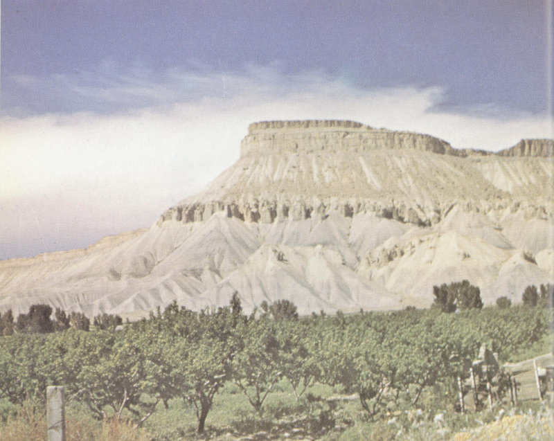
In the arid climate of the Colorado Plateaus, ledges of well-cemented sandstone stand out sharply from slopes of shale or mudstone. The Mesa Verde and Mancos Formations, Cretaceous in age, form the slopes and top of Mt. Garfield near Grand Junction (Jack Rathbone photo)
The peculiar weathering characteristics of flat-lying sedimentary rocks in an arid climate are well demonstrated in Colorado National Monument, Mesa Verde National Park, and elsewhere in the Plateau Province. Those fortunate enough to make a river trip through the Yampa or Green River Canyons in northwestern Colorado or on the rivers of eastern Utah and northern Arizona will have an unusually fine opportunity to observe close at hand the weathering and erosion in this area. Resistant sandstone and limestone layers break into sheer cliffs, often many hundreds of feet high, while the softer layers of mudstone and shale form gentle slopes and terraces. Vast arching caves often develop where resistant layers are undermined—caves sometimes containing ancient Indian dwellings.
II
Geologic History of Colorado
Astronomical and geologic evidence indicates that the earth was probably formed as an immense blob of molten rock, held together and shaped into spherical form by its own gravity. It may even have been gaseous at first, cooling gradually to a molten state. After hundreds of millions of years it became cool enough to begin to harden.
As the surface cooled, a crust formed, and lay like a blanket over the liquid mass beneath. Convection currents—large-scale boiling movements—stirred the molten interior, thrust portions of the crust upward, and sucked other portions downward to be remelted. Some of the lighter components, such as compounds of silicon and oxygen and hydrogen, accumulated on the surface like froth on a kettle: the continents were born. With further cooling the atmosphere and oceans came into being.
Something can be told of the age of the continents. Measurements of radioactivity in the most ancient rocks exposed at the surface today indicate that the oldest known continental rock is between three and four billion years old. Since the continents were formed, they have been bent and shifted and broken by the pressures exerted against them by convection in the interior. Parts of the continents at times have been submerged below the level of the sea, even as they are today. Other portions, lifted above sea level, were immediately attacked by the wearing-down processes of erosion. The battle between mountain-building forces and erosion has been a continuous one ever since the crust was formed. Even now earthquakes give testimony to continued crustal movement, storms still sweep across the continents and wash mud and frost-loosened rocks into churning torrents, rivers still deposit great floodplains and deltas, sediments accumulate slowly but persistently upon the bottoms of the seas.
PRECAMBRIAN ERA
Only part of the earth’s very early history is represented in Colorado, where the oldest known rocks are the gneisses and schists of the Idaho Springs Formation, at least 1,800,000,000 years old. These rocks appear to be the remains of ancient sediments, folded and metamorphosed into vast mountain areas long before recognizable life inhabited the earth.
Precambrian rocks in Colorado are on the whole very poorly known. They have, however, been studied in detail in the Front Range west of Denver and Boulder, where they have been intensively explored for valuable minerals. The lack of fossils in the oldest rocks makes their close correlation difficult, but from studies of radioactive minerals contained in these rocks, and of the relationships of the rock units themselves, we can list them in order of their relative ages.
Note that the rock sequence given below reads chronologically from bottom to top—a logical pattern in geology since younger rocks, especially those of sedimentary origin, normally lie above older ones. Recent studies indicate that the sequence may be much more complex than shown here.
| (youngest) Silver Plume Granite: | light pinkish gray, fine-grained granite. |
| Pikes Peak Granite: | pink, coarse-grained granite. |
| Boulder Creek Granite: | dark gray, faintly banded granodiorite. |
| Coal Creek Quartzite: | light gray quartzite with grains ranging in size from fine sand to boulders, with some interbedded schist. |
| Swandyke Hornblende Gneiss: | dark gray to black, strongly banded gneiss. |
| (oldest) Idaho Springs Formation: | gray to black schist and gneiss. |
From a sequence such as this, it is possible to reconstruct some features of Colorado’s early history. The first chapter of which we have a record is the deposition of the Idaho Springs Formation, probably as an accumulation of mud, sand, and limy mud in an ancient sea. Swandyke deposition followed—the sediments were iron-rich, perhaps derived from ancient volcanic materials. The original Coal Creek sediments were sands and 34 gravels, some of them quite coarse and therefore indicative of near-shore deposition. The schist layers suggest that muds must have been deposited also.
South of Ouray, Cambrian sandstones of the Sawatch Formation lie almost horizontally across the vertical Precambrian metamorphic rocks. (Jack Rathbone photo)
Together these three formations represent some 40,000 feet of sedimentary layers. Deposition of such a great thickness of mud, sand, and lime must have taken a very long period of time. Details of the geography of the continent during that period have 35 of course been obscured by later events, when these rocks were subjected to repeated uplift, crumpling, folding, various degrees of remelting and recrystallization, and erosion. But the ancient sediments must have been derived from even more ancient highlands, either folded and faulted mountains or volcanoes, and probably were deposited under water in broad expanses of sea that covered portions of the continent.
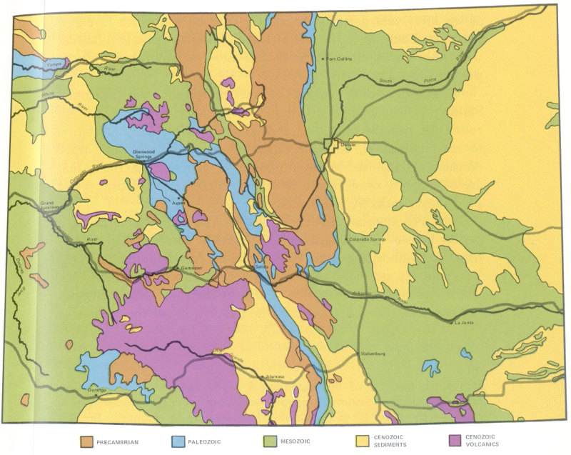
Geologic map of Colorado. Geologic maps show the age of rocks appearing at the surface, disregarding soil cover. A more detailed geologic map of Colorado may be obtained from the U.S. Geological Survey at the Federal Center in Denver.
- PRECAMBRIAN
- PALEOZOIC
- MESOZOIC
- CENOZOIC SEDIMENTS
- CENOZOIC VOLCANICS
- Yampa River
- White River
- Fort Collins
- South Platte River
- Glenwood Springs
- Denver
- Colorado River
- Grand Junction
- Aspen
- Gunnison River
- Colorado Springs
- Gunnison
- Salida
- Dolores River
- Rio Grande
- Arkansas River
- La Junta
- Walsenburg
- Alamosa
- Durango
The Boulder Creek, Pikes Peak, and Silver Plume Granites cut through the metamorphic rocks, and are therefore younger. They represent pulses of molten rock forced upward from deep within the crust, probably during three separate episodes of mountain building. As each set of mountains was formed, it was worn down, perhaps to low rolling hills, perhaps to flat plains almost 36 at sea level, and partially or entirely covered with thick layers of sediment. Each time, another mountain building episode followed, with new intrusions of granite and new metamorphism of the pre-existing rocks.
Each succeeding period of metamorphism and mountain building further changed the nature of the rocks involved, complicating the patterns of folding and faulting, adding recrystallization to recrystallization, until the oldest of the rocks bore little trace of their original sedimentary nature. In general, the rocks that are oldest were most altered by the repeated metamorphism, while the younger rocks were less altered.
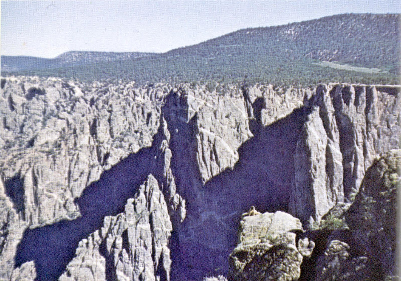
The Black Canyon of the Gunnison River is one of the state’s deep and spectacular chasms. Canyon walls are of Precambrian gneiss intruded by many dikes and highly fractured by later uplifts. The flat upper surface of the Precambrian rocks represents an ancient plain on which, during Jurassic time, the dinosaur-bearing Morrison Formation was deposited. (John Chronic photo)
The Precambrian Era ended with a long period of erosion, a period known to geologists as the Lipalian Interval. During this time, over almost the entire world there was no mountain building. The land lay sleeping, subject only to the forces of erosion. The last mountains were flattened nearly to sea level. Slow, sluggish streams and rivers carried sand and mud toward the oceans—oceans 37 in which perhaps primitive, soft-bodied organisms, with no hard parts to be preserved as fossils, were beginning to evolve.
On the continents, the time of intense metamorphism was over; most rocks of later eras are preserved today in pretty much their original state. The boundary between the Precambrian and later rocks is normally well defined. It is visible at many places in Colorado: in Williams Canyon near Colorado Springs, in Glenwood Canyon, near Red Rocks west of Denver, just west of La Veta Pass, at the top of Royal Gorge and the Black Canyon of the Gunnison. At most of these localities it is a smoothly beveled surface, with highly contorted Precambrian rocks below it and flat-lying Paleozoic sediments above it. Near Red Rocks and La Veta Pass, the same relationship prevails, but the entire contact, and the rocks above and below it, have been steeply tilted by the uplift of the present mountains.
In portions of western North America, deposition late in Precambrian time has left a series of flat-lying rocks between the contorted Precambrian and later Paleozoic sediments. These rocks can be seen in northwestern Colorado, where they form the dark red sedimentary core of the Uinta Mountains.
PALEOZOIC ERA
Geologists have divided the second great era of geologic time into units called Periods. The rocks deposited during a Period are called Systems, but more often than not it is convenient to discuss them in terms of easily recognized units of rock, called Formations. Formations are named after areas in which they are well exposed.
The stratigraphic column given in Chapter I shows the Periods and Systems in their correct order, and gives the age in years for each, as determined by radioactivity methods. As you read, refer as often as necessary to this column.
The geologic map on page 35 will help you locate areas where the rocks discussed in the text are exposed, and will greatly facilitate your understanding of the geology of the state.
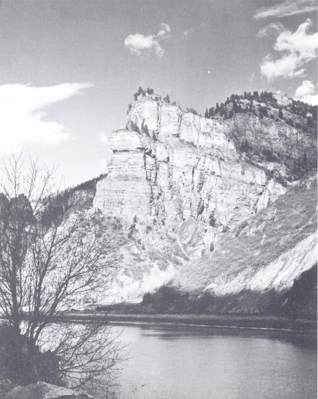
The Cambrian Sawatch Sandstone lies almost horizontally on Precambrian granite in Glenwood Canyon. In the foreground is the Colorado River. (Jack Rathbone photo)
Cambrian Period
(500-570 million years ago)
The first fossiliferous rocks in Colorado were deposited during the Cambrian Period, at a time when over much of the world the seas were creeping in across wide, level plains formed during the Lipalian Interval. Colorado was not covered by these seas until quite late in the Cambrian Period. Beach deposits progressively younger in age suggest that the sea invaded from the west, and spread slowly eastward, inundating most of the central part of the state but not the extreme north or south.
The beach deposits, now called the Sawatch Sandstone because they are well exposed in the Sawatch Range, are composed mostly of fine quartz sand. They are colored with glauconite, a green mineral, and hematite, a dark red mineral, so that the rock has a variegated appearance. The post office at Manitou is built of this red and green rock, and good exposures of it exist in Williams Canyon near Manitou, along U. S. Highway 24 northwest of Manitou, near Red Cliff and Minturn, and in Glenwood Canyon.
The sea which crept over Colorado at this time contained small conical-shelled mollusks, brachiopods, and trilobites. Their shells can occasionally be found in Cambrian rocks in Williams Canyon and in the Sawatch and Mosquito Ranges. At two localities unusual fossils called graptolites have been found in thin Upper Cambrian shales overlying the Sawatch Sandstone.
These fossils can occasionally be found in Cambrian rocks in central Colorado.
Ordovician Period
(440-500 million years ago)
The sea deepened and widened as the Ordovician Period began, and a series of limestones and dolomites was deposited, either on top of the Sawatch Sandstone or, where the Sawatch had not been deposited, directly on the Precambrian. These rocks are now called the Manitou Formation.
The fossils in these rocks are much more varied than those in the Sawatch Sandstone: snails, echinoderms, sponges, cephalopods, brachiopods, and trilobites are common. The Ordovician sea must have teemed with life, as many rocks deposited at this time are more than half composed of animal remains. In addition to hard-shelled animals which formed fossils, there were probably abundant soft-bodied animals such as jellyfish and worms, which left no record of their presence.
After deposition of the Manitou Formation, the seas receded slightly. A new series of sands was deposited above the Manitou in central Colorado. These now form the Harding Sandstone, a formation of unusual interest because it contains remains of the earth’s earliest known vertebrates, primitive jawless fish called Agnathids. In places in the Harding Sandstone there are dense accumulations of the tiny polygonal armor plates from these fish. Although no whole fish have been found, we can reconstruct their appearance by comparing individual plates or groups of plates with later, better known relatives.
Also present in great quantities in the Harding Sandstone are conodonts, peculiar tiny brown tooth-like fossils. Relationships of the conodonts are unknown; they may be parts of the Agnathids, or perhaps they represent some entirely different group of animals, with no living relatives.
After deposition of the sands of the Harding Sandstone, the sea deepened locally and the Fremont Limestone, a massive gray crystalline limestone containing many marine fossils, was deposited. Mollusks (some quite large), brachiopods, and corals contributed their shells to the Fremont Limestone. The chain coral Catenipora and the horn coral Streptelasma may often be used to identify the formation.
The Fremont Limestone was deposited very late in the Ordovician Period. Probably the seas were much more extensive then than present deposits indicate; subsequent erosion has at several times erased the evidence in uplifted areas.
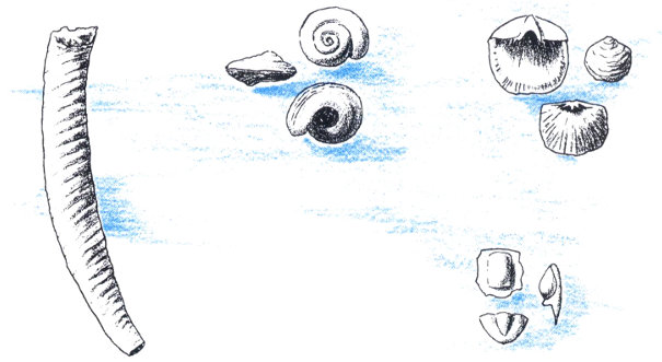
These Ordovician fossils can be found in the Manitou Formation in the Colorado Springs area.
The earliest known fish remains come from the Ordovician Harding Sandstone of central Colorado. These fragments of the protective plates have been magnified about five times.
Corals and coral-like organisms occur in the Ordovician Fremont Limestone.
Silurian Period
(400-440 million years ago)
Until very recently, no Silurian rocks or fossils were known in Colorado, and it was thought that seas did not extend into the state during this period. However, a few years ago good Silurian corals and brachiopods were discovered near the northern edge of the state. They occur in broken blocks and patches of Silurian limestone, mingled with blocks of other sedimentary rocks and, oddly enough, with volcanic material.
What seems to have happened here is that sedimentary layers of Silurian age were present over northern Colorado at one time. During some subsequent period of volcanism, volcanic lavas penetrated these sediments from below. Near the volcanic tubes, broken, angular fragments of the surrounding sedimentary rocks were sometimes carried upward or downward by the motion of the lava.
Much later, both the volcanic outpourings (if the lavas ever reached the surface) and the sediments were stripped away by erosion, probably at a time when mountains were rising in the area. Only the deep portions of the tubes that fed the volcanoes were preserved. These tubes are called diatremes, and thanks to the blocks of sedimentary rock in them we know that there were indeed seas in Colorado during Silurian time, seas containing the abundant life of a shallow marine environment very much like that existing at the same time in Illinois, Iowa, and Indiana.
Devonian Period
(350-400 million years ago)
As far as we know now, Colorado was just a little above sea level during most of Devonian time. Early and Middle Devonian deposits are lacking. Late in the period, however, Colorado was widely inundated once more. Embayments of a western sea covered most of the central part of the state and an area in southwestern Colorado around Ouray.
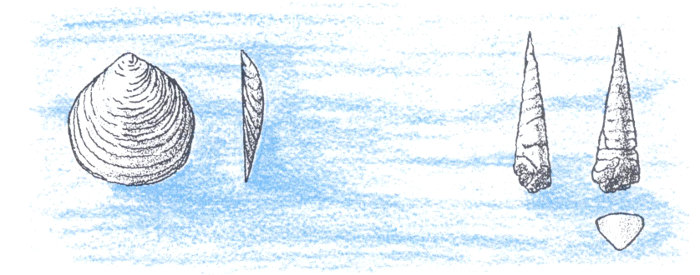
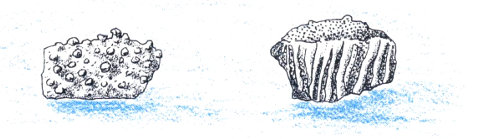
Deposits formed in these embayments have been given several names. Chaffee Formation is the name most commonly used in central Colorado; Ouray Formation identifies rocks of the same age in southwest Colorado. The Chaffee Formation has been subdivided into two well defined units, the Parting Sandstone or Quartzite, and the Dyer Dolomite or Limestone. Many ore deposits 43 are associated with these rock units—notably deposits of lead and zinc. The Parting Sandstone is frequently so well cemented with silica that it is actually a quartzite; thin shale beds or “partings” make it easy to recognize. It frequently contains remains of fossil fish and distinctive beds of algae.
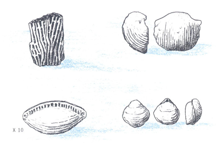
The Dyer Dolomite contains brachiopods and bryozoans, mollusks and corals. Some of the best fossil hunting in Colorado is in Dyer beds around the White River Plateau, where the fossils frequently weather out of the rock as almost perfect specimens.
These Devonian brachiopods come from the White River Plateau in western Colorado.
Mississippian Period
(310-350 million years ago)
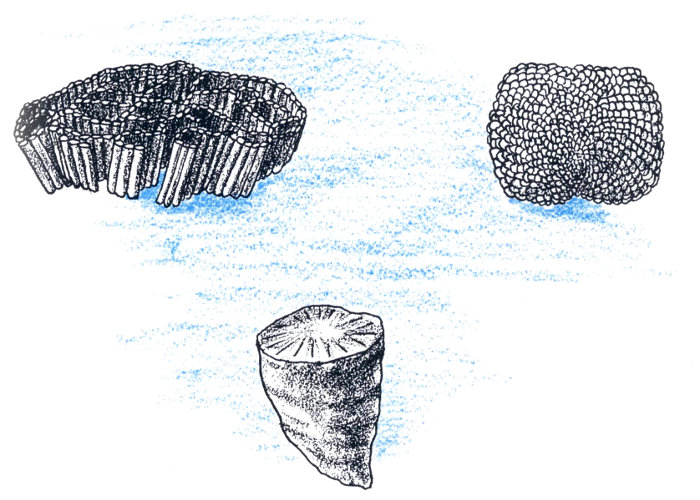
The sea continued to cover most of Colorado after the end of the Devonian Period, well into Mississippian time. Mississippian rocks are characteristically thick, massive gray limestones collectively called the Leadville Limestone. This unit is well known as the host rock for many Colorado ore deposits, notably those around the town of Leadville.
During Mississippian time the western sea, warm and rich in organisms, covered much of North America. Brachiopods and corals flourished, as did many other forms of life. The seas during part of this time extended completely across Colorado to merge with seas that covered the midwestern part of the United States.
Over all this vast area, as well as southwest into Arizona, the gray, massive, fossiliferous Mississippian limestone is remarkably 44 uniform and easily recognized, although it is called by different names in different areas.
Late in Mississippian time, the Colorado area rose slightly and the sea in which the Leadville Limestone was deposited receded. An interval of erosion followed. The surface of the limestone was dissolved and pitted, tunnels and caves formed where running water etched deep into the rock, and a reddish soil formed on the surface and in the hollows. This portion of the limestone, which in some places also contains pebbles of chert, is named the Molas Formation. Part of the Molas may be Pennsylvanian in age.
Mississippian fossils from western Colorado show that seas covered much of the state about 330 million years ago.
Pennsylvanian Period
(270-310 million years ago)
As the Pennsylvanian Period began, the Colorado area continued to rise. Earliest deposits of this age are fine-grained black shales and sands—the Glen Eyrie Formation along the southern Front Range and the Belden Formation in west central Colorado. Then, through millions of years, mountain-building took place. Some areas rose more than others, so that formerly flat-lying marine sediments were bent and broken, and a series of high mountain ridges and deep basins were formed. Geologists sometimes call these the Ancestral Rocky Mountains.
Although the pattern of the mountains changed repeatedly, the Ancestral Rockies consisted principally of two large ranges. One range roughly paralleled the present Front Range, but lay thirty to fifty miles further west. The other extended from the San Luis Valley northwest toward Colorado National Monument, including the area around the Black Canyon of the Gunnison and the present Uncompahgre Plateau. Coarse sediments washed off both sides of both ranges, and accumulated as alluvial fans and valley fill along the mountain margins. These exist today as the Fountain Formation of the eastern Front Range, the Minturn Formation between the ancient uplifts, and the Hermosa Formation west of the western uplift.
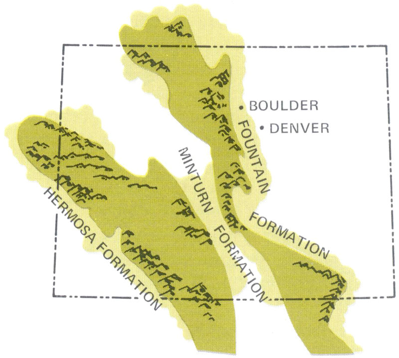
This paleogeographic map reflects the distribution of land and sea during the early part of the Pennsylvanian Period and shows where coarse sediments derived from the Ancestral Rockies were deposited.
- FOUNTAIN FORMATION
- MINTURN FORMATION
- HERMOSA FORMATION
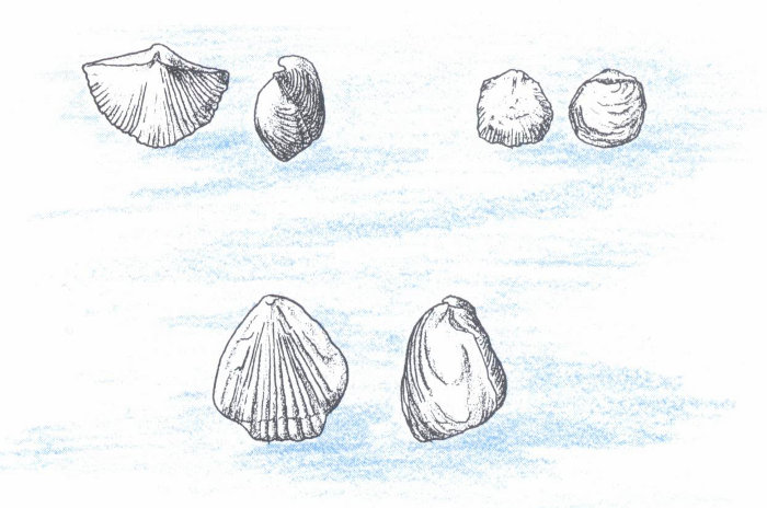
West of Denver, the main line of the Denver & Rio Grande Railroad tunnels beneath steeply dipping sandstones and conglomerates of the Fountain Formation. (Jack Rathbone photo)
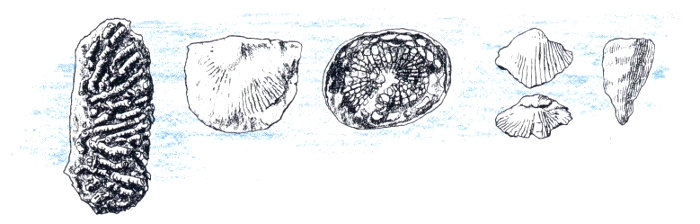
Corals, brachiopods, and fusulinid Foraminifurida can be found in the Pennsylvanian Minturn Formation at many places in the Mountain and Plateau Provinces.
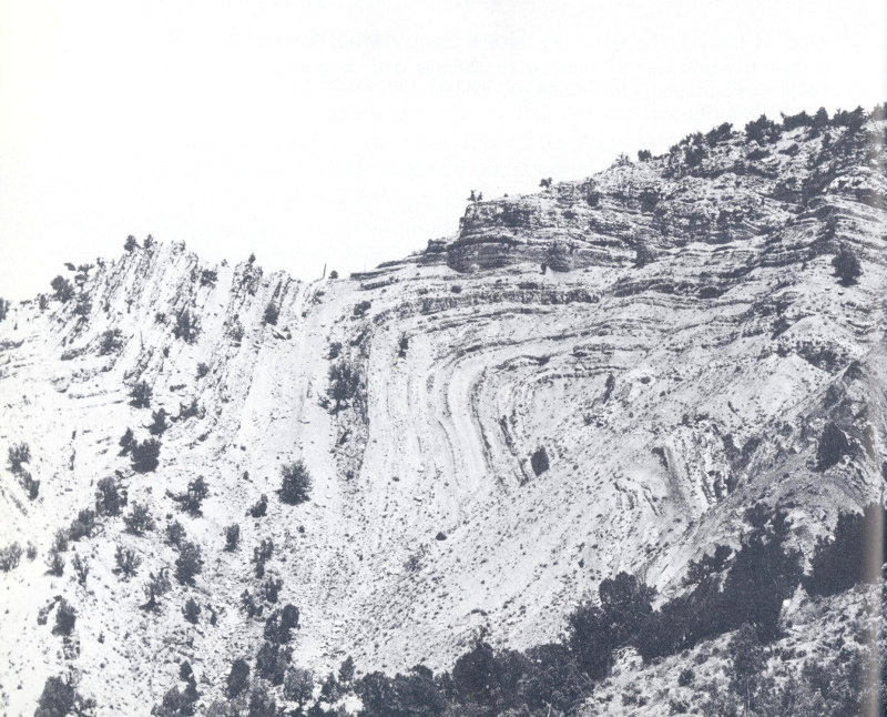
In western Colorado, where vegetation is sparse, rock structures are clearly defined. This photograph shows beds of the Pennsylvanian Minturn Formation sharply folded, probably as a result of the deformation of gypsum in underlying layers. (Jack Rathbone photo)
In the Flatirons near Boulder, Red Rocks Park near Denver, and the Garden of the Gods near Colorado Springs we see well exposed examples of the Fountain Formation. The Minturn Formation is visible along the Eagle River west of Wolcott, and along Gore Creek near Vail. The Hermosa Formation forms striking red cliffs north of Durango. In the Sangre de Cristo Mountains area, exceptionally great and rapid deposition took place, and the Minturn Formation is very thick.
In west central Colorado, near the towns of Eagle and Gypsum, a large basin formed. In it, gypsum and other salts were deposited as arms of the sea were cut off from the main marine area. The unusual appearance of the hills along the Eagle River, especially north of U. S. Highway 24, is caused by the presence of gypsum in the bedrock.
In a similar manner, the Paradox Basin was formed in southwestern Colorado. Thousands of feet of gypsum, salt, and potash were deposited here, probably also precipitated in restricted arms of the sea. These minerals, the so-called evaporites, have since significantly controlled development of the landscape in Gypsum Valley and other parts of this region. (See The Plateaus in Chapter I and the section on Gypsum in Chapter III).
Between the mountain masses and their surrounding alluvial deposits, shallow seas repeatedly invaded the lowland areas of the state. Marine fossils in some parts of the Minturn Formation bear witness to as many as twenty marine cycles. Strangely, the Pennsylvanian Period appears to have been cyclical in other parts of the United States as well, for marine sediments are found alternating with nonmarine sediments in Pennsylvania, Illinois, Kansas, Nebraska, and New Mexico. In middle Pennsylvanian time, general uplift occurred in Colorado, and almost the entire state was above sea level for the rest of the period.
Permian Period
(223-270 million years ago)
By the end of the Pennsylvanian Period, the mountains of the Ancestral Rockies had been almost entirely removed by erosion, and the deep basins were filled with sediments. Colorado was once more a great plain, sloping gently to the northeast. In eastern Colorado, a shallow sea gradually dried up, leaving some thin limestone and gypsum beds along its margin. The western shore of this sea was edged with beaches and sand dunes, preserved as the Lyons Sandstone. The buildings of the University of Colorado, as well as many homes and other structures in the Boulder-Denver area, are faced with this beautiful salmon-colored sandstone.
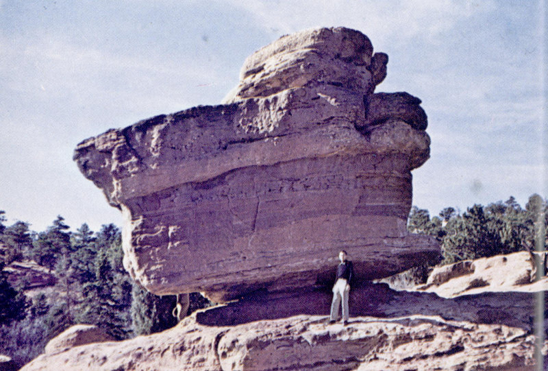
Balanced Rock, in the Garden of the Gods northwest of Colorado Springs, is an erosional remnant of iron-rich conglomerate and sandstone. It remains while the rest of the surrounding layers are gone because it is harder and more completely cemented together by silica. The rock is part of the Late Paleozoic Fountain Formation. (John Chronic photo)
In the western part of the state, Permian deposits consist mostly of shales and sandstones. The red color of these rocks, and the complete absence of fossils in them, suggest that the environment in which they were deposited was not marine, but was a vast, level mudflat subject to alternating wet and dry periods. The shales and sandstones collectively are called the Maroon Formation, named for Maroon Bells, near Aspen, where they are dramatically exposed in the mountain cliffs.
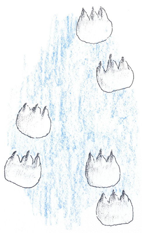
Tracks of Permian reptiles called Laoporus coloradoensis occur in the Lyons Sandstone near Lyons. These are about life size.
During part of Permian time, a shallow sea extended from Idaho, Utah, and Wyoming into the northwest corner of Colorado. In this sea was deposited the Phosphoria Formation, a highly phosphatic limestone containing only rare, poorly preserved molluscan fossils.
As the Paleozoic Era ended, Colorado was still flat and low-lying. By this time land plants and animals had evolved, but if vegetation grew in the Colorado area, or animals roamed it, they left few fossil remains. Tracks of early reptiles have been found in the Lyons Sandstone. Dune sandstones here and in adjacent areas suggest that desert conditions may have prevailed, in which case Colorado would have been very similar, scenically and climatically, to Sahara regions today.
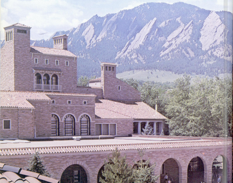
Dark red Pennsylvanian and Permian conglomerates form the Flatirons that overlook the University of Colorado campus at Boulder. University buildings are faced with Permian Lyons Sandstone quarried along the foothills of the northern Front Range. (University of Colorado photo)
MESOZOIC ERA
The Mesozoic Era, popularly known as the Age of Reptiles or Age of Dinosaurs, is divided into three periods. The climate of the entire earth appears to have been warmer then than it is at present, perhaps because of a different distribution of land and sea areas, or because continental areas were not as high and mountainous as they are just now. Colorado was a rather low land area for most of the first two Mesozoic periods; then a vast sea covered the entire state for the remainder of the era.
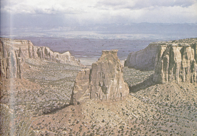
The pink cliffs of Colorado National Monument are made of Wingate and Entrada Sandstones. Underlying them, in the valley bottom, Chinle shales form steep red slopes. (William C. Bradley photo)
Triassic Period
(180-225 million years ago)
Saharan conditions continued to prevail in western North America during the early part of the Mesozoic Era. In central Colorado, the lowest Mesozoic deposits are the Triassic Lykins Formation, a series of soft, bright red sandstones and shales. Where the Lykins is exposed along the Front Range, its bright 52 red color identifies it. Because of its softness, it is often less prominent than adjacent rock layers in the mountain foothills. The Lykins Formation includes some evaporites, apparently derived from Permian evaporites washed into the Triassic ponds and lakes which existed occasionally in this region.
Over almost the entire state, the rocks deposited at this time are very similar. Formation names may differ—Lykins, Moenkopi, Chinle, Ankareh, Wingate—but the rocks are almost universally fine-grained sandstones and shales with a red or pink color. They represent ancient coastal plain, dune, or delta deposits. Toward the western edge of the state they coarsen, and contain layers of conglomerates similar to the Triassic conglomerates of northern Arizona and Utah. These suggest that mountain-building was taking place west of here at that time.
There are virtually no fossils known from Triassic rocks in Colorado, although some fossil palm fronds have been found west of the San Juan Mountains, in the southwestern corner of the state.
Jurassic Period
(135-180 million years ago)
During the Jurassic Period, Colorado was still a low, flat desert area with intermittent streams flowing eastward over the surface of older sediments. The Navajo Sandstone, formed from dune sands, was deposited in the western part of the state. Streams flowing eastward from Utah brought fine sediments—silts and muds—to western Colorado, forming what is now the Carmel Formation. Near Canon City, coarse gravels bear witness to local uplift in Jurassic time. Both these gravels and the Carmel Formation were overlain by more dune sands, now hardened into the Entrada Sandstone.
In Late Jurassic time the Colorado area, which had been predominantly desert since Permian time, appears finally to have been submerged once more. Fine calcareous muds of the Curtis Formation, containing ammonites, belemnites, and other marine shellfish, show us that a shallow sea transgressed from the west over the wind-blown sands. This sea was, geologically speaking, of short duration—only a few million years. Bounded on almost all sides by desert, it seems to have dried up, depositing the gypsum that is now present in a thin layer along the Front Range between Denver and Canon City in the Ralston Formation.
At about this time, however, the climate underwent a major change. Deposits above the Ralston indicate an increasingly moist environment, the environment in which the Morrison Formation was deposited over most of Colorado and parts of the adjacent states of Kansas, Arizona, Utah, and Wyoming. The Morrison Formation is exposed in many places, and is characteristically composed of layers of fine, limy mud, brightly colored in streaks of red, brown, green, and blue. In most areas it is so soft that it becomes soil-covered; it is well exposed only in roadcuts or where it is protected from erosion by a “caprock” of harder sediments or lava. Spectacular outcrops can be seen in new roadcuts along U. S. Interstate highway 70 just west of Denver.
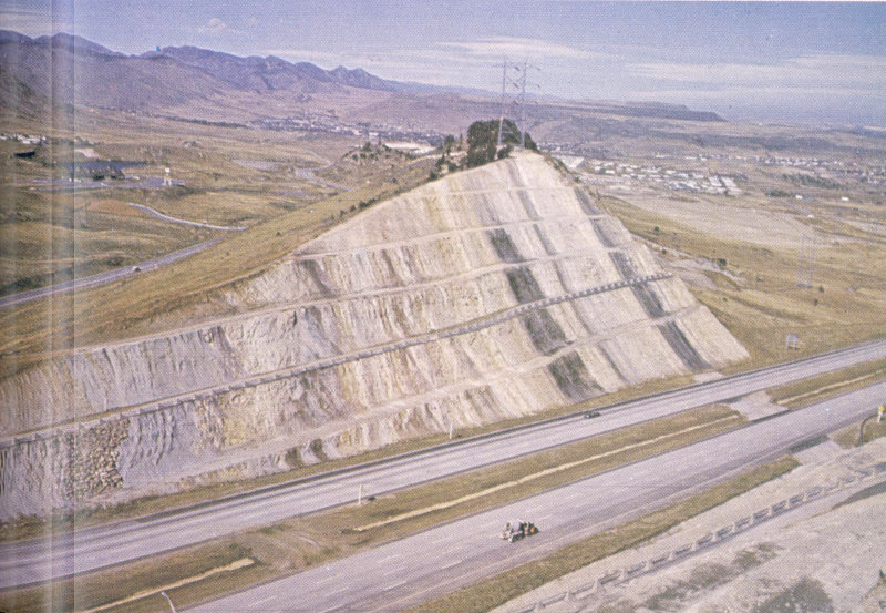
In this roadcut along U. S. Interstate 70 west of Denver, Jurassic and Cretaceous rocks are unusually well exposed in the Dakota hogback. Green and purple shales represent the dinosaur-bearing Morrison Formation. The Cretaceous Dakota Group forms the eastern, higher half of the cut. Black layers are carbon-rich clays of the South Platte Formation, frequently quarried locally for ceramic uses. (John Chronic photo)
Fossil dinosaur bones occur in great numbers in the Morrison Formation near the towns of Morrison and Canon City and at several other places in Colorado. Those at Canon City have been quarried extensively, and are now mounted in a number of museums in the United States. At Dinosaur National Monument, in eastern Utah and northwestern Colorado, many excellent remains have been found; those in Utah can be seen in place in the rock in a striking exhibit at the National Monument.
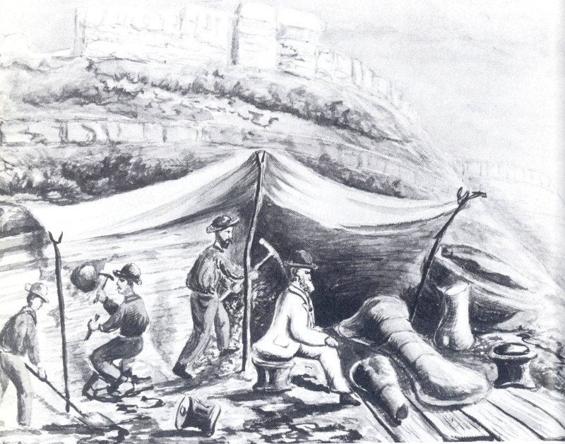
In an old painting, a paleontologist contemplates fossil bones found near Morrison. The date is 1877. The bones are those of the 70-foot dinosaur Apatosaurus, more commonly known as Brontosaurus, shown below in reconstruction.
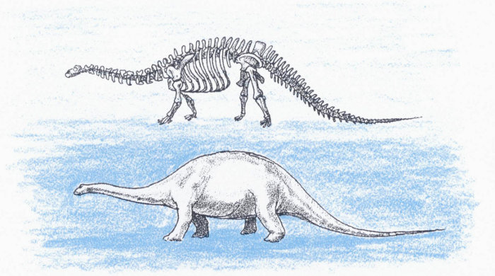
Some of the dinosaurs known from the Morrison Formation reached 80 feet in length. Both plant-eating and meat-eating types are known. In addition to the bones themselves, gastroliths or gizzard stones can frequently be found; these highly polished stones were as essential to dinosaur digestion as gravel is to a chicken or a caged canary.
Along with the dinosaur fossils are found abundant remains of water plants called charophytes. These plants formed tiny spiralled balls of calcite as part of their reproductive activities; both the little balls and the stalks of the plants themselves occur in many parts of the state. In western Colorado, near Grand Junction, silicified shells of freshwater snails can also be found in the Morrison.
Early in the 1900s vanadium, radium, and uranium were discovered in Jurassic sandstones and mudstones of western Colorado. Extensive mining in this area has revealed that these elements often become concentrated by groundwater in organic material such as fossil plant stems or dinosaur bones. The search for radioactive minerals has thus brought to light many ancient fossil accumulations.
Cretaceous Period
(70-135 million years ago)
Early in Cretaceous time, marine conditions once more prevailed in Colorado. This is indicated by a marked change in rock types from beach and near-shore deposits to true marine sediments.
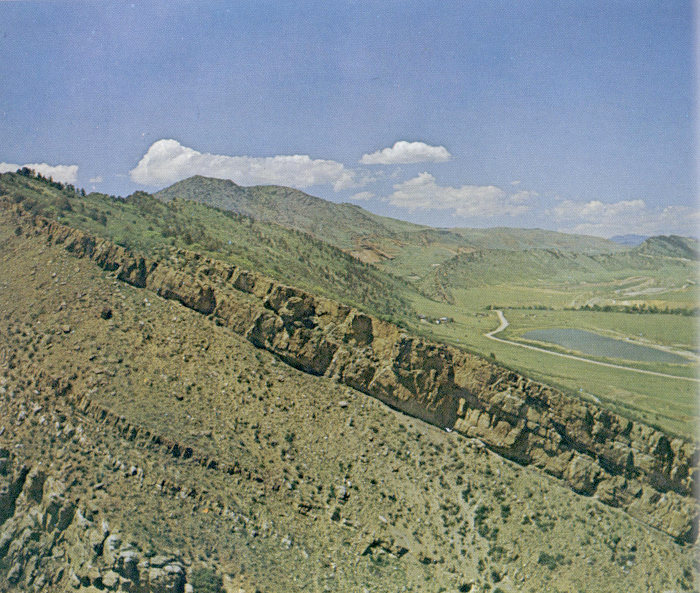
Between the Front Range and the Plains the Cretaceous Dakota Formation forms a hogback ridge which can be traced for 200 miles or more. The well-cemented sandstone resists erosion, and so remains as a ridge when softer layers are stripped away. (Jack Rathbone photo)
The sandstones derived from beach sands sometimes include coarse pebbles of chert which can be traced to sources in Permian rocks of Utah and Nevada. Occasionally the beach and near-shore deposits include marine shells like oysters, indicating that there were brackish and salt water lagoons and marshes along the shore. The Dakota Formation represents the beach of the transgressive or advancing sea. This formation contains oil in eastern Colorado, Nebraska, and Wyoming; the oil itself may have been 57 derived from decay of organic materials in swamps behind the beaches and bars.
As the sea deepened in eastern Colorado, finer sediments were deposited. These included the black muds of the Benton Shale, and the Niobrara Limestone, a shallow-water deposit containing abundant shells of clams (Inoceramus and Ostrea) and ammonites and tiny one-celled animals called Foraminiferida. Above the Benton and Niobrara Formations lie the fine gray muds of the Pierre Shale. Several thousand feet thick, the Pierre contains occasional beautifully preserved ammonite shells as well as bones from fossil fish and swimming reptiles.
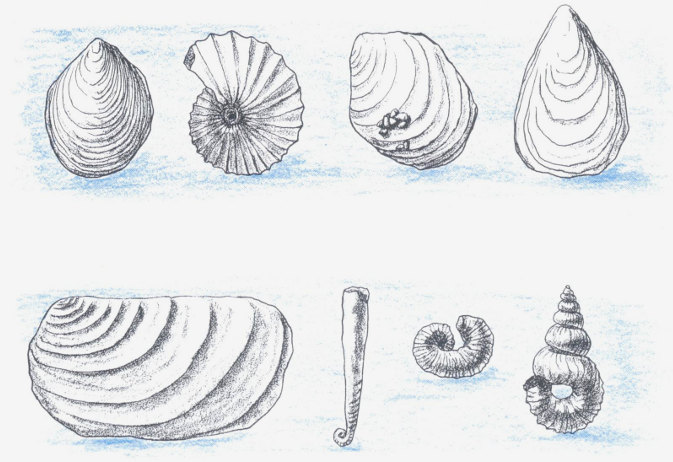
Cretaceous rocks in Colorado are rich in fossil pelecypods. Each of the fossils illustrated above may grow to a much larger size than shown.
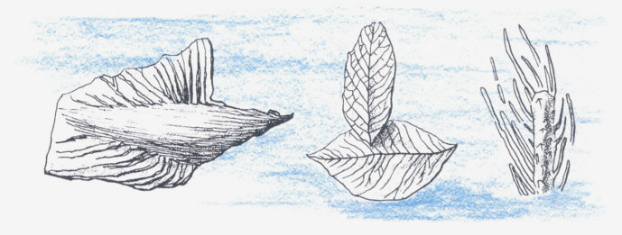
Shales of the Laramie Formation contain many recognizable plant fossils.
The rocks deposited in western Colorado at this time are markedly different from those deposited in eastern Colorado. In the east, deposits are fine and very limy, containing abundant shells and little in the way of coarse debris. In the west, sandstones of the Mesa Verde Formation dominate, and coal beds suggest marshy or swampy conditions inshore from the ancient ocean. This is just the pattern we would expect from a low-lying region bordering a shallow sea, a region similar perhaps to the southeastern Atlantic and Gulf coasts of the United States today.
Toward the end of the Cretaceous Period, the sea receded from Colorado. Beaches and bars of the retreating sea left a sandstone layer which now outcrops prominently east of the Front Range as the Fox Hills Sandstone. Above lie interbedded sands and coals, the Laramie Formation. The presence of coal above beach sands shows that the coal swamps moved eastward as the sea retreated.
The exact age of the shoreline deposits and coal beds varies from place to place in such a way as to indicate that the sea withdrew slowly and irregularly. In general the shore moved eastward, but there are localities such as North Park where deposition lasted much longer than elsewhere. In some places no real beach was formed at the ancient strand line.
In western Colorado, the end of Cretaceous time is marked by coarser beds, indicating an increased rate of uplift in Utah. Conglomerates were deposited in the beds of the McDermott Formation, now visible along the Animas River south of Durango.
CENOZOIC ERA
It is characteristic of earth history that the younger the rocks are, the more we know about them. This is because younger rocks lie near the surface, have not been disturbed as much by mountain building processes as have older rocks, and have not been affected as strongly by repeated erosion. Many of the events of the Cenozoic Era are documented in detail in the geology of Colorado, and these events have intimately influenced the scenery as we see it today.
The Cenozoic is the Age of Mammals. How it happened that mammals triumphed over reptiles is one of the mysteries of geology. Some scientists think that climatic changes—dropping temperatures and increases in rainfall—swung the balance in favor of the warm-blooded mammals. Others believe that cosmic ray bombardment during some unusual astronomical event may have destroyed many surface-living dinosaurs, while small burrowing mammals (as well as many small reptiles) were able to survive. Still others maintain that the superior intelligence and regulated body temperatures of mammals enabled them to win out in the battle for survival without the aid of climatic or cosmic change.
The names Tertiary and Quaternary, used for the two Cenozoic Periods, are holdovers from early studies in geology in which rocks were divided into Primary (very hard, crystalline rocks such as igneous and metamorphic rocks), Secondary (well consolidated layered rocks), Tertiary (layered rocks which are not fully cemented but which are nevertheless fairly well consolidated), and Quaternary (sediments in which the grains have not become cemented together).
Tertiary Period
(3-70 million years ago)
During the first part of the Tertiary Period, uplift began in earnest in Colorado and adjacent states. This uplift was part of the great Laramide Orogeny that built the Rocky Mountain chain from Alaska to New Mexico. The entire area rose above the level of the sea, and mountains were thrust up in a great series of north-south ranges that extended unbroken almost the length of the continent. Between the ranges, thick layers of gravel and sand, 60 derived from the surrounding highlands, were deposited in intermontane basins. Occasional freshwater limestones and shales indicate the presence of lakes.
In Colorado, many details of the formation of the Rockies stand out in bold relief. The Front Range moved upward sharply, mostly as a linear block broken or faulted along both edges. Paleozoic and Mesozoic sediments along the margins of the block were steeply tipped and in some places even overturned, while in some localities Precambrian rocks were thrust out over the younger sediments.
Just east of the Front Range, especially in the area around Denver, the land remained lower and was the site of thick deposits of gravel and sand eroded from the range. The Denver Formation, the Arapahoe Conglomerate, and the Dawson Arkose are more than 2,000 feet thick in this area. These are delta and river sediments, all varying a great deal from place to place. Individual layers of sand or gravel are not continuous over extensive areas, but some, such as the Castle Rock Conglomerate, are very prominent locally.
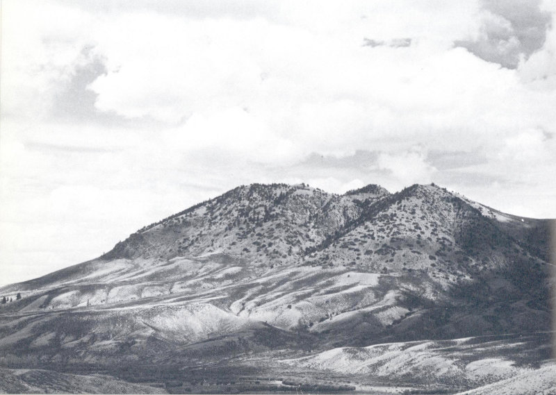
On Wolford Mountain, just north of Kremmling, Precambrian granite lies on top of Cretaceous shale. The older rocks were thrust up and over younger rocks during the Laramide Orogeny. The position of the fault shows clearly because trees prefer the granite soil above the fault to the shale below. (Jack Rathbone photo)
Along the eastern margin of the Front Range west of Castle Rock and Sedalia, rocks deposited at this time are now folded steeply, indicating that the mountains continued to rise even as basin sediments were being deposited.
In southern Colorado, the Sangre de Cristo and Wet Mountains were also formed as upthrust blocks. Between them, the Huerfano Basin and adjoining Raton Basin received particularly rapid alluvial deposition. In the Raton Basin, quantities of vegetation were deposited in swamps and marshes, forming the thick coal beds which can now be seen in road cuts west of Trinidad and along the Raton Pass highway. Huerfano Basin deposits contain some of the earliest known horse remains, skeletons of a tiny four-toed horse called Hyracotherium (formerly known as Eohippus).
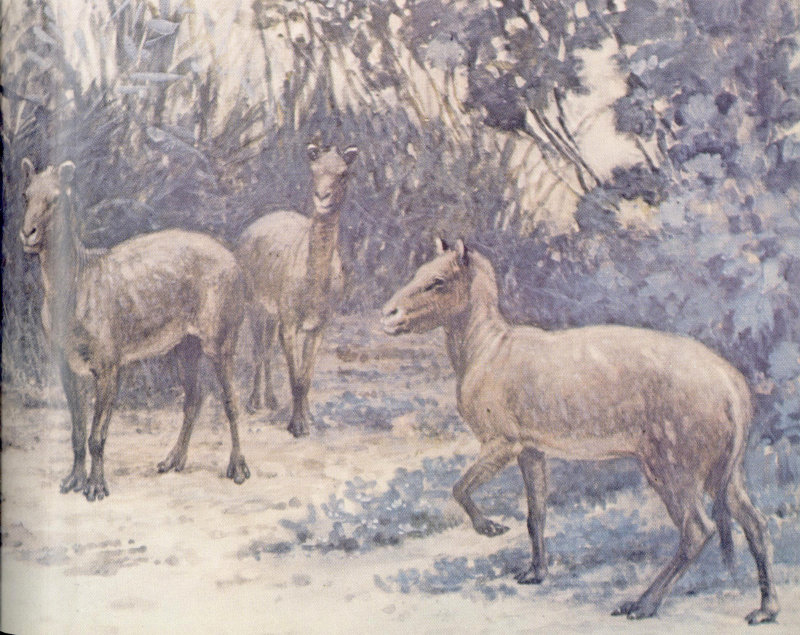
Bones of Hyracotherium, the “dawn horse,” have been found northwest of Walsenburg in Early Tertiary sediments of the Huerfano Basin. (C. R. Knight painting, courtesy American Museum of Natural History)
Other rising ranges provided material for alluvial deposition in North Park, Middle Park, South Park, and the San Luis Valley. 62 Layers of basalt and volcanic peaks show that as the mountains rose, the crust cracked and allowed lava to rise to the surface in great quantities. Tertiary basalts are very much part of the Colorado landscape: some can be seen west of Granby, others in Table Mountains east of Golden. Near Boulder, Valmont Dike was intruded, though lava may not have reached the surface in that area. Spanish Peaks in southern Colorado, Mesa de Maya, the Rabbit Ears Range, Grand and Battlement Mesas, and many other volcanic features were formed at this time.
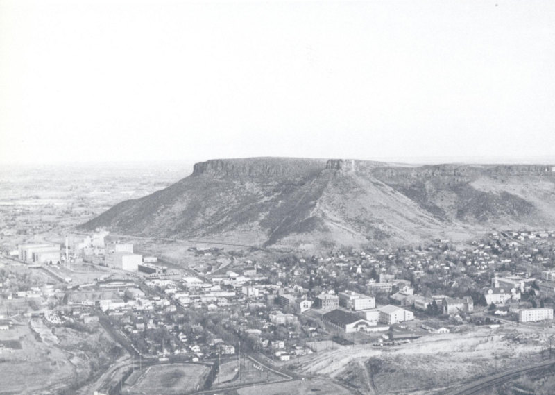
The town of Golden nestles between the Front Range and South Table Mountain. Tertiary basalt capping South Table Mountain covers beds of the Denver Formation. It thins to the right, or south, indicating that its source was probably to the north or northwest. Buildings in the right foreground are the Colorado School of Mines. (Jack Rathbone photo)
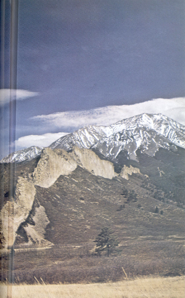
A series of almost vertical dikes radiate from West Spanish Peak. Surrounding sediments are Tertiary. Weathering and erosion along sets of joints in the largest dike have shaped it into the “Devil’s Staircase.” (Jack Rathbone photo)
Most of the rich mineral deposits of Colorado are thought also to have been formed during the early part of the Tertiary Period. Solutions rich in gold, silver, zinc, lead, copper, and sulfides of iron seeped into joints and faults in the crust as the mountains were pushed upward. Ore minerals crystallized out, sometimes in veins in the ancient Precambrian igneous and metamorphic rocks, sometimes in Paleozoic sediments. These are further discussed in Chapter III.
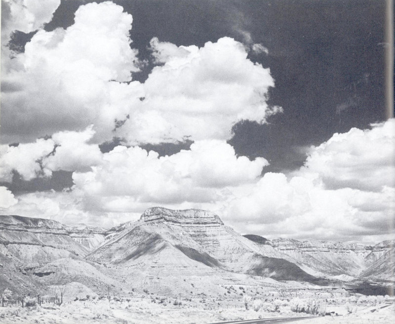
The Eocene Green River Formation includes great thicknesses of oil shale, an untapped petroleum reserve containing perhaps three trillion barrels of oil. The richest part of the oil shale is a dark brown layer called Mahogany Ledge, visible here on cliffs just west of Rifle. If placed in a campfire, fragments of this shale release enough oil to burn with a yellow, smoky flame. (Jack Rathbone photo)
Further to the north and west, the Uinta Mountains rose. They are a fault-block range, but they lie at right angles to the general north-south trend of the Rocky Mountains. South of them the Uinta Basin, one of the largest of the intermontane basins, received shaly deposits in a great lake which existed here for probably several million years. The lake extended over some 100,000 square miles, and during its existence great quantities of tiny organisms lived in its waters. Oily material from these 65 organisms was deposited in the mud of the lake sediments, particularly in the eastern end of the basin, there to remain trapped in a great oil-shale deposit. Fossil fish, crayfish, algae, and many forms of insect and plant life have been found as fossils in these lake shales.
West of Pikes Peak, another lake formed, dammed by a lava flow from a nearby volcanic field. Fine volcanic ash falling into this lake preserved the trunks and leaves of many plants as well as abundant insects, fish, and occasional mammal bones. These are now protected and exhibited in Florissant Fossil Beds National Monument. The fossil plants, among them redwoods, poplar, hackberry, and pine, suggest a climate warmer than the present one, and have been taken to indicate that regional uplift to the present altitude had not yet occurred.
Another rich deposit of fossil insects and plants occurs near Creede. Other lake deposits in South Park contain ash layers with fossil algae and snails.
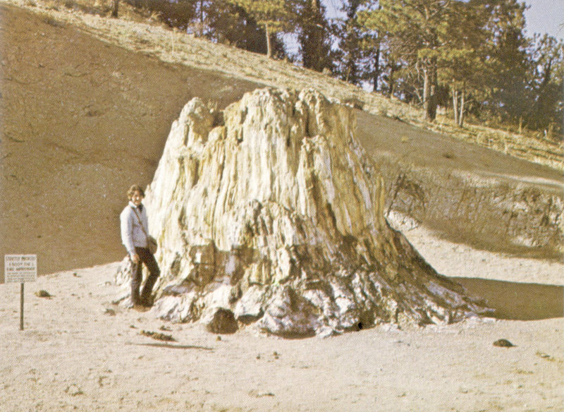
Large petrified trunks of redwoods and other trees can be seen at Florissant Fossil Beds National Monument, west of Colorado Springs. (John Chronic photo)
In southwestern Colorado, extensive Tertiary lava flows, ash falls, and river deposits form the eastern part of the San Juan Mountains, the largest volcanic area in the state. Mineral collectors 66 are attracted to this region by the many excellent localities for agate and other siliceous stones.
Still another center of Tertiary volcanism was located in what is now Rocky Mountain National Park. Specimen Mountain, northwest of Trail Ridge, was an active volcano about 30 million years ago, shedding ash and lava over much of northern Colorado. The rhyolite which now caps the hill west of Iceberg Lake, on Trail Ridge Road, was derived from this volcano, but is now separated from it by the deep glaciated valley of the Cache la Poudre River and Milner Pass.
Volcanic ash at times drifted far eastward and blanketed the surface of the plains, burying specimens of many animals and plants. The White River Formation, extending from northeast Colorado northward into South Dakota, is formed of such drifting ash. Many now-extinct mammals have been excavated from this formation.
Sometime after the mid-Tertiary episode of violent volcanic activity, Colorado was uplifted to its present altitude. This was a general uplift, raising the plains and plateau areas as well as the mountains. The uplift was not an abrupt process, but continued for perhaps ten million years. It raised the entire state 3,000 to 5,000 feet above its previous level.
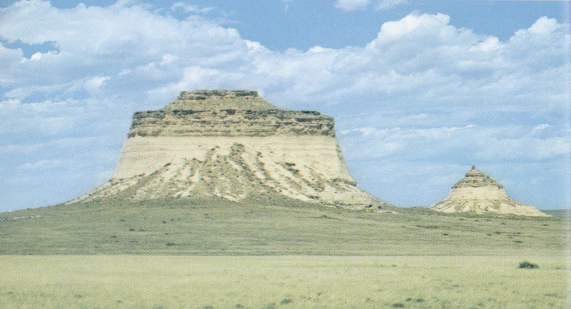
Pawnee Buttes, about 40 miles north of Fort Morgan, rise like castles from the eastern Prairie Province. Remnants of Oligocene and Miocene sedimentary rock that once covered much of northeastern Colorado and adjacent states, they contain jaws, teeth, and other bones of primitive mammals. (Department of Highways photo)
During the remainder of the Tertiary Period, Colorado was 67 the site of erosion rather than deposition. However, some stream material was deposited in the mountain valleys, and on the prairies wind-blown and stream-borne sands were spread thinly, interlayered with impure limestones deposited in ponds and lakes. In the San Luis Valley, deposition was probably more continuous than elsewhere, as the exit from the valley was blocked by volcanic flows. The deposits in this valley, sands and clays of the Santa Fe and Alamosa Formations, form a great artesian basin. The rich agricultural development of the valley is made possible by water wells tapping these formations.
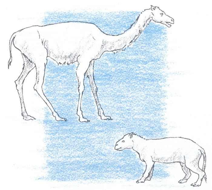
Remains of many now-extinct mammals have been found in Tertiary sedimentary rocks of northeastern Colorado, in the general area of Pawnee Buttes. Those illustrated are Oreodon from Oligocene strata and a “giraffe-camel” (Oxydactylus) from Miocene rocks.
Quaternary Period
(3 million years ago to present)
The most significant feature of the Quaternary Period in Colorado, as elsewhere in the northern hemisphere, is the evidence of glaciation. During the first part of the Quaternary Period, known as the Pleistocene Epoch, great continental glaciers covered most of Canada and much of northern United States. The ice sheets did not extend southward as far as Colorado, but large valley glaciers developed in many of the mountain ranges of the state and left their traces in many mountain valleys.
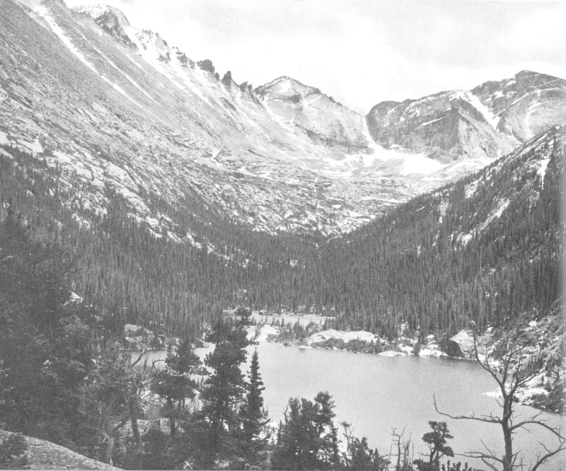
Mills and Jewel Lakes, in Rocky Mountain National Park, occupy small glacier-gouged basins in Glacier Gorge. The flat-topped peak at the upper left is Longs Peak, elevation 14,256 feet; Pagoda Mountain is in the center of the skyline. Bedrock in this area is Precambrian granite, gneiss, and schist at the Front Range “core.” (Jack Rathbone photo)
The conditions leading to Pleistocene glaciation are not fully understood. Climatic changes may have been initiated by a decrease in solar radiation, changing patterns of ocean currents, 69 reduction of solar heating by volcanic dust, or an increase in general elevation of the land. As the climate became cooler and moister, snowfall increased in the north and at high altitudes. In areas where winter snowfall exceeded summer melting, glaciers developed.
In Colorado, glaciers formed along the crests of the Front Range, the Sawatch Range, the Elk Mountains and West Elk Mountains, the Sangre de Cristo and Mosquito Ranges, the San Juan Mountains, and the Park and Gore Ranges. Glaciation in Colorado was selective: in many places elevation was sufficient for glaciation, but snowfall apparently was not great enough. Where they did occur, the glaciers extended down to elevations of about 8,000 feet. There, temperatures became mild enough to melt the ice.
The mountain glaciers have left many tell-tale signs of their presence. Valleys above 8,000 feet are U-shaped, their upper ends bounded by horseshoe-shaped, steep-walled cirques. In the lower portions of the valleys, at elevations just above 8,000 feet, lie long lines of glacial debris known as moraines: terminal moraines forming crescents across the valleys to show where melting glaciers dropped their rocky loads; lateral moraines along the sides of valleys; medial moraines where glaciers from two valleys met. Terminal moraines, often forming effective barriers across the present streams, may act as dams, creating lakes such as Grand Lake in Rocky Mountain National Park.
There were at least three distinct glacial episodes in Colorado. This is known because careful studies of glacial debris in moraines reveal three different degrees of rock weathering. All three stages can be seen in or near Rocky Mountain National Park. The oldest is represented by a moraine about three miles west of Estes Park, where the Big Thompson River traverses a wide U-shaped valley before entering its narrow, unglaciated canyon. The next oldest is represented in terminal moraines further up the valley, at Aspenglen campground. The youngest is shown in a prominent terminal moraine about one mile west of the park entrance in Horseshoe Park.
A large lateral moraine separates Hidden Valley from the south side of Horseshoe Park, and an almost equally large lateral moraine is present on the north side of this valley. At Moraine Park, both sides of the valley are edged with lateral moraines also.
Studies in Rocky Mountain National Park have revealed many other details of glaciation in this area. These are described in Park Service brochures and guidebooks, in the museum at Park headquarters, and in informative roadside signs.
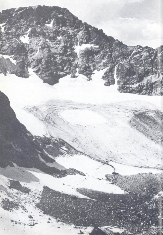
A line of hikers approaches Arapaho Glacier, west of Boulder. Movement of the glacier is evidenced by the crevasses apparent just below the snowfield in the dirty gray glacial ice. (H. H. Heuston photo)
Several small glaciers are still present in the Colorado mountains, all in sheltered cirques above 11,000 feet. These may be remnants of the former larger glaciers, or new glaciers formed after a long warming episode. A hike to one of these glaciers is a rewarding experience for anyone interested in geology. Some of the more accessible are St. Mary’s Glacier west of Denver, Arapaho Glacier west of Boulder (the Boulder Chamber of Commerce sponsors a festive hike to Arapaho Glacier every August), and Tyndall Glacier in Rocky Mountain National Park.
The Ice Age brought drastic changes also to the landscape below 8,000 feet elevation. Heavily loaded with glacial debris, mountain streams disgorged coarse sands and gravels along the mountain front and in the intermontane basins. As the glaciers melted after each period of expansion, the swollen streams cut deeply into their former deposits and into much older rocks as well. Royal Gorge, the Black Canyon of the Gunnison, and many of the deep, colorful canyons of the Plateau Province were cut or at least deepened by these waters. The canyons along the east face of the mountains—Big Thompson, Boulder, Clear Creek, and others—were also deepened and sharpened by the rushing ice-fed torrents.
On the prairies, rivers dumping their loads of sand covered the older rocks. Sand dunes developed along the river channels. Bones and huge tusks of hairy mammoths were sometimes buried in these soft deposits; now they are occasionally revealed as the dune and river sands are washed or blown away by continuing erosion.
About 20,000 years ago, man arrived in Colorado. Soon after this, the water supply of the valleys diminished greatly, and erosion slowed down correspondingly. The climate gradually became semiarid to arid. Many features of the natural scene were much as they must have been a century ago, without the highways, dams, and television aerials of today. Buffalo and many smaller types of game roamed the plains and foothills; deer, elk, and bighorn sheep were plentiful in the mountains. Nomadic tribes camped and hunted in both mountain and prairie. In the western part of the state, homes could be built in the shelter of great caves, as at Mesa Verde, and game could be supplemented with corn and squash planted on plateau surfaces.
Several features of Colorado scenery changed with increasing aridity. The glaciers of course were gone or nearly gone. Streams were no longer the violent torrents they had been. Many mountain lakes, filled with sediment and vegetation, became instead mountain meadows. And the once fertile intermontane valleys became deserts.
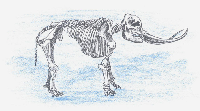
During the last Ice Age, elephant-like mastodons roamed Colorado. As present-day erosion removes sediments, bones, teeth, and tusks are frequently exposed, especially in the Prairie Province. (C. R. Knight painting, courtesy American Museum of Natural History)
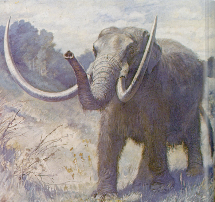
On the eastern side of the San Luis Valley, the Great Sand Dunes developed at this time. These dunes nestle against the Sangre de Cristo Range, where strong southwesterly winds blowing across the wide valley tend to funnel toward Mosca and Music Passes. These winds lift loads of sand from the lightly vegetated valley floor, and drop it as they rise over the mountains. Where the sand is dropped, the dunes have formed. They rise to about 700 feet above the valley floor, and cover about forty square miles. The low rainfall of the area, seven to eight inches per year, keeps vegetation from creeping over the dunes and makes them a most distinctive feature of Colorado, a lesson in geology in the making.
* * * * * * * *
Geologic processes in Colorado now seem to be much reduced from what they were a few thousand years ago. Reduction in rainfall has led to reduced erosion. Mountain-building, having reached a climax in Tertiary time, has declined markedly. However, we find evidence that volcanism has occurred within the last few thousand years and faulting within the last few hundred, and Colorado streams rise after sudden mountain storms to approximate the violent torrents of glacial times. Colorado’s scenery, fashioned during some three billion years of earth history, is ever changing.
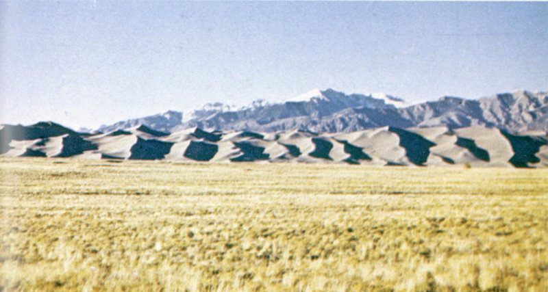
The Great Sand Dunes of Colorado were formed during Pleistocene and Recent time by deposition of quartz sand lifted from unconsolidated alluvial deposits in the San Luis Valley. The highest of the dunes rises 700 feet above the adjacent valley floor. (John Chronic photo)
III
Geology and Man in Colorado
Colorado’s first permanent settlers arrived in 1858, when gold was discovered in river sands near what is now the city of Denver. The ensuing gold rush, coming ten years after the rush to California, rivalled it in fury and brought sudden wealth to lucky miners and the adventurous merchants who grubstaked them. Several hundred mining towns or “camps” sprang into existence almost overnight, their sites determined by the geology of the mountain areas. The cities of Denver, Boulder, and Golden were established as milling and shipping centers for the products of the mines. In 1876 the now-wealthy area, previously part of Kansas Territory, became the State of Colorado.
For more than a hundred years Colorado’s minerals—products of her long and diverse geologic history—have influenced her development in many ways. The state’s early wealth, stemming from bonanzas in gold and silver, is evidenced by palatial homes, hotels, and public buildings constructed during the first few decades of mining activity. Some of these are still standing—the opera houses at Central City and Aspen, Central City’s famous Teller House, and the Grand Imperial Hotel at Silverton are examples.
Many of the stories and legends of Colorado’s gold camps are recounted in Stampede to Timberline, by Muriel Sibell Wolle, delightfully illustrated with sketches of old mining towns as they appear today. Mining in Colorado, published by the U. S. Geological Survey, also makes fascinating reading, as it contains many historical anecdotes and eyewitness accounts of gold-rush days.
Development of the metal-mining areas in Colorado followed a definite sequence. Placer gold was usually discovered first. Recovery of placer gold was followed by mining of gold from veins or “lodes.” Although at first only native gold was mined, gold-bearing compounds such as telluride were soon recognized as an additional source, especially at Gold Hill, Cripple Creek, and of course the camp that came to be known as Telluride. As gold sources were depleted, silver, first produced as a byproduct, became of prime interest. Lead and zinc were in turn byproducts of silver mining. Other metals, notably copper, vanadium, tungsten, and iron, were produced later. Molybdenum is the Johnny-come-lately of the state’s mining industry, but is 75 now the chief metal produced. A uranium boom in the 1950s brought a short rush to western Colorado and new vigor to the economy.
Oil was discovered near Canon City in 1862. The nearby Florence field and a small, shallow field near Boulder preceded much greater discoveries in the Denver Basin, the Uinta Basin, and southwest Colorado. Oil reservoirs, confined to areas of sedimentary rock, are found primarily in the Prairie and Plateau Provinces of the state, and recovery of the oil has done much to distribute population to these areas.
Coal is also restricted to sedimentary rock areas. Coal production in Colorado has waxed and waned with the years, but has provided fuel for export, for the railroads, for the manufacture of electric power, and for many of the state’s industries.
A good picture of present mineral production in Colorado can be obtained from the following summary for 1971, prepared by the Colorado Bureau of Mines:
| Product | Value |
|---|---|
| Molybdenum | $105,389,456 |
| Petroleum | 90,494,459 |
| Sand and gravel | 32,842,503 |
| Coal | 30,251,443 |
| Natural gas | 18,695,225 |
| Uranium | 18,048,692 |
| Vanadium | 15,863,554 |
| Cement | 13,377,520 |
| Zinc | 13,310,787 |
| Lead | 6,582,025 |
| Tungsten | 6,360,020 |
| Limestone and dolomite | 5,397,570 |
| Silver | 4,198,054 |
| Fluorspar | 3,887,210 |
| Copper | 3,875,976 |
| Stone | 1,961,279 |
| Gold | 1,832,791 |
| Clay | 962,986 |
| Iron | 880,047 |
| Pumice | 309,370 |
| Tin | 278,862 |
| Gypsum | 253,856 |
| Pyrites | 142,640 |
| All others | 1,091,927 |
| Total | $376,288,252 |
Colorado is now the nation’s leading producer of molybdenum, tin, and vanadium, and second in output of tungsten. In oil production it ranked twelfth among the states in 1968, but ninth in reserves, with 420,000,000 barrels of proven reserves on 1 January 1969. An as yet untapped source of oil lies in the oil shales of western Colorado.
As part of the natural environment, water plays a major role in man’s activities. Water problems in Colorado revolve mainly around the best use of runoff in a state whose major catchment basins are across the continental divide from her largest population centers and most fertile farm land. Groundwater, closely related to surface water distribution and movement, is a geological problem, and in Colorado as in other states many government and private geologists serve farm and industrial communities in the search for usable supplies.
CAUTION: Old mines are dangerous! They may contain water or deadly gases, or be on the verge of collapse. Keep away from abandoned prospect pits and mine shafts. WARN AND WATCH YOUR CHILDREN.
GOLD, SILVER, AND OTHER METALS
Colorado’s placer and lode sources of gold, which gave first impetus to the series of mining booms in the state, were fantastically rich. Summit and Lake Counties, for instance, each produced more than $5,000,000 in placer gold between 1859 and 1867. During the same nine-year period, more than $9,000,000 in lode gold was produced from Gregory Gulch, a tiny canyon between Central City and Black Hawk. Other districts rivalled or surpassed these figures.
Early in the game it was recognized that almost all the deposits occurred along what came to be known as the “mineral belt,” a fifty-mile-wide zone extending southwest from the Boulder region. Most of the metals mined in the state come from this belt, but there are three notable exceptions: Cripple Creek, Silver Cliff, and western Colorado vanadium and uranium districts. In the first few years of the Colorado rush, gold ores and placer gold were discovered only in the northeastern part of the mineral belt. Gradually the belt was found to extend further and further southwest: Tincup was discovered in 1861, Silverton in 1870, Lake City in 1871, and Telluride in 1875. Aspen, on the western edge of the belt, was not discovered until 1879, perhaps because the area was difficult of access and lacked the easily recognizable native gold.
In the northeast part of the mineral belt, gold and other minerals occur in veins in Precambrian granite and gneiss. In the Leadville and Aspen areas, ores are associated with altered Paleozoic limestones. At the southwest end of the mineral belt, in the San Juan Mountains, ore veins are found near or in Tertiary volcanic rocks. Native gold, gold-bearing compounds, and other metallic ores in these veins originated where mineral-rich solutions from deep within the earth penetrated fissures and joints in the surrounding rock. Regardless of the age of the host rock, almost all the ores of Colorado were deposited in the early or middle Tertiary Period, about 35 to 70 million years ago.
Gold and silver are no longer mined extensively in Colorado, although any summer Sunday will see weekend operators panning near mountain streams or trundling rock from one-man mines. The recent rise in the price of silver has encouraged many miners to reopen old shafts. The most active mines in the state today are those producing molybdenum, lead, zinc, and vanadium. (Vanadium, although a metal, usually occurs in Colorado with 78 radioactive minerals, and so is discussed with them rather than with the metals.)
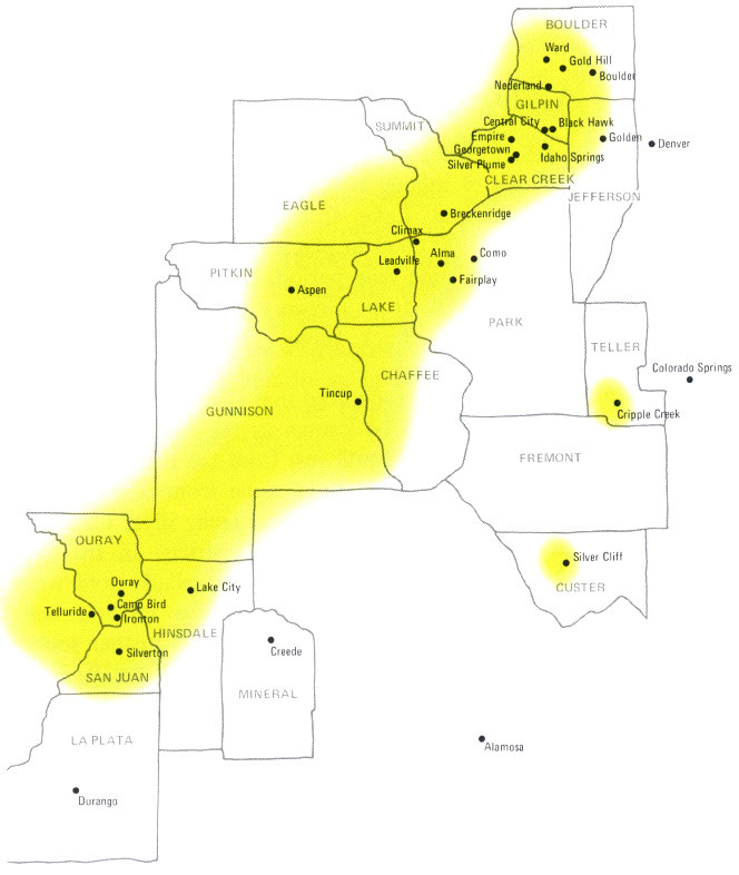
The Colorado mineral belt extends from Boulder County on the northeast to San Juan County on the southwest. Almost all of the prominent mining districts in Colorado lie along this belt. Cripple Creek and Silver Cliff, however, lie far to the east of the general trend.
- Telluride
- Denver
- Colorado Springs
- Alamosa
- BOULDER
- Ward
- Gold Hill
- Boulder
- Nederland
- GILPIN
- Central City
- Black Hawk
- JEFFERSON
- Golden
- CLEAR CREEK
- Empire
- Georgetown
- Silver Plume
- Idaho Springs
- SUMMIT
- Breckenridge
- EAGLE
- PITKIN
- Aspen
- GUNNISON
- Tincup
- CHAFFEE
- PARK
- Climax
- Alma
- Como
- Fairplay
- TELLER
- Cripple Creek
- FREMONT
- OURAY
- Ouray
- Camp Bird
- Ironton
- SAN JUAN
- Silverton
- HINSDALE
- Lake City
- LA PLATA
- Durango
- MINERAL
- Creede
- CUSTER
- Silver Cliff
All told, some 430 metal mining districts have been established as legal entities in the state of Colorado. Each of these districts had the right to draw up its own regulations concerning prospecting, claims, and mining rights, within a framework established by the Federal government. Only a few of the districts ever became really significant producers. The geology and history of several of the leading areas are presented in the pages that follow.
Boulder County
Gold Run, near Gold Hill, was the scene of one of the earliest strikes in Colorado. Gold was found here in December 1858, and was sluiced from stream sands and mined from veins early in 1859. Active placer mining lasted only about a year, however, and lode mining dropped off rapidly as near-surface oxidized ores were worked out. When a smelter was erected at Black Hawk in 1868, and sulfide ores could be treated, there was a revival of activity. In 1869 the Caribou and Poorman mines near Nederland were discovered; they quickly became the most active mines in the county. The Ward district opened soon after.
In 1872, a gold-silver telluride called petzite was found in veins at Gold Hill. Renewed prospecting in this area resulted in location of mines near Sunshine, Salina, and Magnolia. During the years that followed, new mines appeared almost as fast as old ones were depleted. In 1892, the peak year, more than $1,000,000 in gold and silver was produced; total production has been about $25,000,000.
In 1900, a black mineral common in the Nederland area was recognized as ferberite, an ore of tungsten, and a new rush to the area started. During the next eighteen years Boulder County was the main tungsten producer in the United States; about 24,000 tons of tungsten trioxide, worth $23,000,000, were produced here. The ore was found in nearly vertical veins six inches to three feet thick, in a lenticular area about nine miles long extending from Nederland northeast to Arkansas Mountain, four miles west of Boulder.
Boulder County is characterized by an abundance of small mines. Old shafts, pits, and mine buildings can be found throughout the central part of the county. Little mining is done here today; many of the towns that once peppered these hills have fallen into decay or disappeared entirely.
Central City and Idaho Springs
The Central City-Idaho Springs area was the principal metal mining region in the state until the late 1880s. In 1858, rich placer deposits were discovered in gravels and river terraces along both forks of Clear Creek. Exploration upstream led to discoveries of rich oxidized quartz veins at Central City, Black Hawk, and Idaho Springs. These veins, which generally trend northeast-southwest, extend through the mountains in a zone about six miles long and three miles wide between the two forks of Clear Creek.
The ores filled a multitude of cracks and fissures in the Precambrian bedrock. The veins are usually less than five feet thick, and are almost vertical and often clustered in zones up to thirty feet wide. The position of one of the vein systems may be seen clearly between Black Hawk and Central City—the ore-bearing rock has been mined out, but a series of collapsed tunnels marks the line where the veins crossed the valley. A monument here commemorates the discovery of Gregory Gulch, one of the richest localities in the state.
Several rich veins were mined in both directions—southwest from Central City and northeast from Idaho Springs—until the mines met. The Argo tunnel, marked by dilapidated buildings and extensive dumps on the north side of Idaho Springs, connected the two districts; it was completed in 1904.
The “Patch,” a deep crater-like hole on Quartz Hill, about one mile southwest of Central City, is an intriguing feature in this area. It was produced by glory-holing, a mining technique in which a deep tunnel is deliberately caved by blasting, so that ores above the tunnel can be removed. This glory hole was dynamited below an irregular mass of highly broken rock where many ore-rich veins converged. After the caving, ores were taken out through the remaining part of the tunnel.
The principal ore minerals of Central City and Idaho Springs are native gold, pyrite, sphalerite, galena, chalcopyrite, and tennantite. Prospecting for uranium was carried out during the 1950s but no uranium was ever mined here.
The area has produced almost $200,000,000 worth of gold, silver, lead, zinc, and copper. A few mines still operate seasonally or on a small scale, but tourists, many of them riding Jeeps across the mountainous terrain to visit mines and ghost towns, are often more visibly active than the mines.
Georgetown, Empire, and Silver Plume
A few miles southwest of Idaho Springs, another mining area had a similar, though less productive, history. In 1859, placer and lode gold were discovered near what is now Georgetown. Placer mining dominated here between 1859 and 1863. Gravel and crushed rock from decomposed quartz and sulfide veins were washed through sluiceboxes in the same way as placer gravel, gold being caught in riffles or gunny sacking on the bottoms of the troughs. The veins were found to be decomposed to depths of about 40 feet; below this the gold occurred closely associated with sulfides such as pyrite, sphalerite, galena, and chalcopyrite, from which it could not easily be separated. However, smelters were developed in 1866 for treatment of these sulfides, and gold, silver, lead, and copper were recovered. Gradually, as the gold was worked out, silver and lead became the important products of the mines.
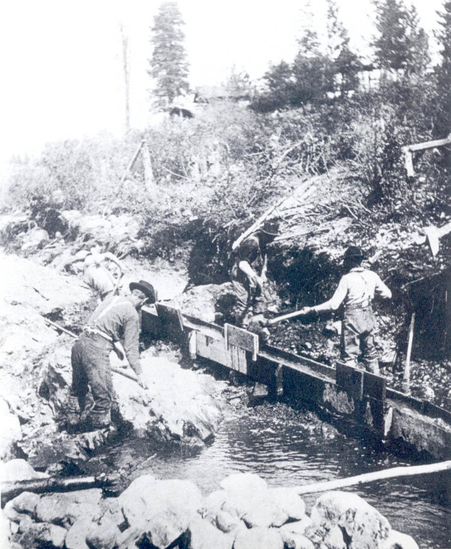
Sluicebox mining was a common sight near the early gold camps, where primary recovery was from placer deposits or decomposed quartz and sulfide veins. (State Historical Society of Colorado photo)
Leadville
Placer gold was discovered in 1859 in California Gulch, about seven miles north of the present town of Leadville. The rush that followed was short but sweet; the camp was called Oro—gold! About $5,000,000 was produced from the placer mines within two years, though by 1861 the area was all but deserted, for the easily won placer gold was gone.
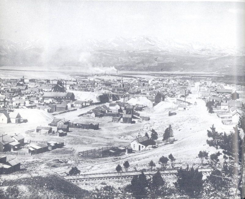
Early-day Leadville sprawled among its mine dumps at an elevation of 10,200 feet. The Sawatch Range, in the background, contained many smaller mining communities, now deserted. Mt. Massive, the state’s second highest peak, forms the crest of the continental divide here. (State Historical Society of Colorado photo)
In 1875 a smelter was erected a few miles downstream from Oro to process cerussite—silver-rich lead carbonate—that occurred in the placer sands. For years this mineral had been considered a nuisance because, being much heavier than sand, it tended to separate out with the gold. The new town of Leadville sprang up near the smelter and shortly afterward more lode deposits were discovered south of the placer workings. From $63,000 in 83 1875, production climbed to $2,500,000 in 1878 and more than $15,000,000 in the peak year of 1882.
Geologically, the ores of this district occur as Tertiary replacements and veins in Ordovician, Devonian, and Mississippian limestones. The “Blue” or Leadville Limestone, of Mississippian age, contains the richest ore. Ore deposits were formed after the limestones had been faulted and cracked extensively by mountain-building movements; the ores themselves probably crystallized from molten or gaseous materials involved in related igneous intrusions. River gravels and glacial debris mask the true nature of the lode deposits, but studies in the mines show that the fault systems along which ores are deposited trend north or north-northeast.
The Leadville district is now experiencing its third mining boom as a newly recognized lead-zinc orebody is being developed. Production is expected to reach 700 tons of ore per day by 1971. Total production of gold, silver, lead, zinc, and copper in the district has reached $500,000,000.
Breckenridge
Breckenridge was also discovered in 1859, with placer gold the first attraction. The placers gave out in 1862 after about $3,000,000 in gold had been recovered. Earliest attempts to mine the rich silver and lead veins of the district were in 1869.
As at Leadville, the sedimentary rocks of the area were intruded by granitic masses in Tertiary time, but here the sedimentary rocks are mostly Pennsylvanian sandstones and shales. These rocks were badly faulted and broken during the intrusion, and the ores were deposited as the granitic material cooled. The lode deposits occur mostly in small veins well hidden by surface sands and gravels. Some of the veins yielded exceptionally beautiful crystallized wire and flake gold, specimens of which are on display at the Colorado School of Mines library in Golden and in the Denver Museum of Natural History.
Dredging for alluvial gold was attempted in 1898 in the Breckenridge district, but this method of extracting gold was not successful until 1905. A number of dredges operated between 1910 and 1925. These floating behemoths shovel up gold-bearing gravels from the bottom and one side of the pond on which they 84 float, sort out the gold in giant sluiceboxes, and spew out the leftover gravels in great arc-shaped heaps that can be seen near Breckenridge and Fairplay and in a number of other valleys in Colorado. They depend for their operation on a plentiful supply of water and a shallow water table, but they can sift through quantities of gravel at relatively low cost. All told, about $7,000,000 in gold has been dredged from this district.
Fairplay
This gold dredge, still floating in its pond just south of Fairplay, operated from 1941 to 1952. With chains of buckets like those in the foreground, it dug gravel 70 feet below water level, carving a 35-foot bank above water level; in effect it mined to a depth of 105 feet. This dredge extracted nearly 115,000 ounces of gold from about 33 million cubic yards of gravel (John Chronic photo)
Another gold field discovered in 1859 was in the northwest corner of South Park, along the headwaters of the South Platte River. Several mining camps were established here. After early production of rich placer deposits, claims were consolidated and large flumes constructed so that gold could be recovered by 85 hydraulic mining. In this type of mining, streams of water from high-pressure hoses are directed at gravel surfaces. The gravels are washed into long sluiceboxes, where gold is caught in riffles. Hydraulic mining continued upstream from Fairplay until about 1900.
In 1922 a dredge was constructed near Fairplay to process gravel along the South Platte and in the valley floor. An even larger dredge, constructed in 1941, operated until 1952, when rising labor costs overrode the narrow margin on which it operated. At the time operations ceased, the dredge was recovering about six cents in gold for each cubic yard of gravel processed.
Placer gold has always been the principal mineral product of the Fairplay area, but native gold also occurs in the surrounding mountains in quartz veins, and many small mines were developed to extract it. Sulfide ores were also mined; they contained silver, lead, and zinc as well as gold. In the Mosquito Pass and Horseshoe Amphitheater areas, there is renewed activity now because of the recent rise in the price of silver.
Silverton
Gold was discovered in the San Juan Mountains of southwest Colorado in 1870. The earliest mine, near what is now Silverton, was located by a group of prospectors sent out by Governor Pile of New Mexico Territory. Since the site was on Ute Indian land, real mining did not begin until a treaty allowing it was ratified in 1874.
Production in the Silverton district has been from veins in Tertiary volcanic rocks within an elliptical area known as the Silverton cauldron. Here the volcanic rocks, part of the several thousand feet of lava flows and ash falls of the San Juan volcanic field, were cracked and faulted by a second period of igneous activity. Ores formed in the cracks and fissures.
In the 1870s the Silverton district was very remote, and difficulties with transportation retarded activity there. In 1882, however, a narrow-gauge railroad was built connecting Silverton with Durango, and the problem of transporting ore out of the isolated mountain valley was simplified. The railway still exists; a train makes daily passenger runs during the summer—the only remaining operating narrow-gauge line in the United States. The 86 track follows the Animas River canyon, whose cliffs and crags are dotted with long-abandoned mines, prospect holes, and mine buildings, monuments to the tenacity and determination of the men who mined here.
Production in this district was more than $22,000,000 in gold and $20,000,000 in silver between 1874 and 1923. New activity is evident here, as in other silver-rich areas of Colorado, because of recent demand for silver, lead, and zinc.
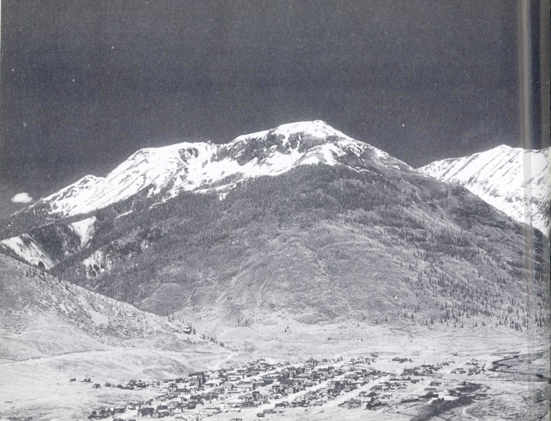
Silverton lies in a remote mountain valley in the San Juan Mountains. Silver, gold, lead, and zinc have been mined here since 1874. Storm Peak, composed of Tertiary volcanic rocks, forms the backdrop; the narrow-gauge railroad track is visible in the foreground. (Jack Rathbone photo)
Ouray
Ouray was settled in 1875, when gold and silver deposits were found near Mount Sneffels. Since 1877, mines in Ouray County have produced over $35,000,000 in gold and $32,000,000 in silver. The district is still quite active: in 1965, mines in this area produced more than $9,000,000 in gold, silver, copper, lead, and zinc, about a third of total Colorado production of these metals for that year.
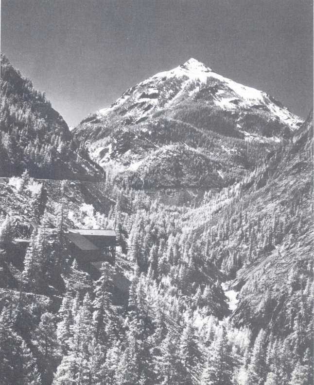
A few miles south of Ouray, along Uncompahgre Gorge, an old mine clings to the slope below the Million Dollar Highway (U. S. 550). Abrams Mountain rises in the background. The Precambrian Uncompahgre Quartzite outcrops up to about the road level; Miocene Sunshine Peak Rhyolite caps the peak. (Jack Rathbone photo)
A mile north of Ouray a prominent intrusive stock marks the center of mining activity closest to Ouray. The richest deposits of the Ouray area, however, lie about five miles southwest, near 88 Mount Sneffels and Red Mountain Creek. There, several large mines, including the famous Camp Bird mine, have operated for many years, extracting ore from hundreds of veins that underly the surface. Some of these veins are two to four miles long. They are in Tertiary volcanic rocks of the San Juan Formation. Quartz and calcite are the common gangue (non-economic) minerals, and pyrite, sphalerite, galena, and chalcopyrite are the most abundant ores. Most of the silver is in the galena; gold occurs in streaks and nodules associated with quartz.
About ten miles south of Ouray, along the “Million Dollar Highway” (U. S. 550), the Red Mountain district lies on the northwest edge of the Silverton volcanic cauldron. It contains a number of small pipelike bodies very rich in silver-copper and silver-lead ores. Following the mid-Tertiary volcanism and ore intrusion, surface rocks in this area were intensely oxidized: resulting iron oxides now form the gaudy reds and yellows of Red Mountain and the slopes near Ironton. This alteration, as well as the fact that much of the area is covered with fallen rock, stream gravels, or glacial deposits, compounds difficulties of locating the small though high-grade ore deposits.
The Idarado Mine, on the east side of U. S. highway 550 near Red Mountain, used to produce ores from nearby volcanic pipes; now it produces from veins some distance to the northwest. The area is honeycombed with tunnels and shafts.
Aspen
Silver was found at Castle Creek and on Aspen Mountain in 1879. A group of prospectors from Leadville, apparently after examining maps of the Geological and Geographical Atlas of Colorado published in 1877, explored along the line of Paleozoic limestones encircling the Sawatch Range. As they had hoped, they found ores similar to those at Leadville in rocks of the same age.
Mining began at Aspen in 1880. Here, as at Leadville, intrusion of granite porphyry into or near the Leadville Limestone had broken and deformed the layers, and ores were deposited in fissures and as replacements during cooling of the intrusions. The intricacy of faulting which controls the ore pockets in the limestone is well shown on the map of Aspen Mountain in Chapter II.
Glaciation occurred in this area, and glacial deposits cover most of the ore bodies and outcrops so that little bedrock is 89 exposed. Mapping was accomplished by extrapolating to the surface the bedrock patterns shown in mine pits, shafts, and tunnels.
Aspen produced some of the richest silver ores in the world, and thrived as a boom town for most of two decades. In 1888 the value of ores produced reached over $7,000,000; the next year it topped $10,000,000. After the silver crash of 1893 production declined rapidly; the last mines were closed in the 1920s. Total production of silver, lead, zinc, and copper reached about $100,000,000. There was virtually no gold in the ores at Aspen.
Creede
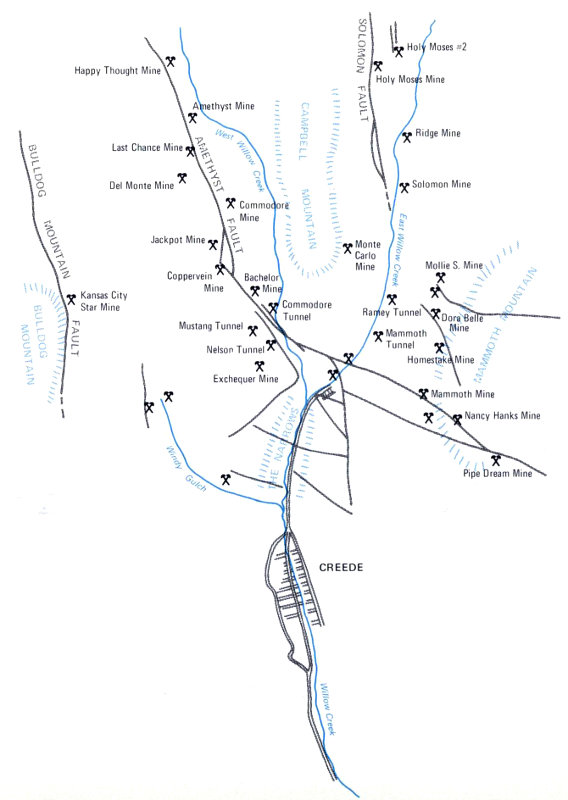
Creede and its mines are located in an area of Tertiary rhyolite and dacite, light-colored volcanic rocks.
- Happy Thought Mine
- Amethyst Mine
- West Willow Creek
- AMETHYST FAULT
- Last Chance Mine
- Del Monte Mine
- Commodore Mine
- Jackpot Mine
- Coppervein Mine
- Bachelor Mine
- BULLDOG MOUNTAIN FAULT
- Kansas City Star Mine
- Commodore Tunnel
- Mustang Tunnel
- Nelson Tunnel
- Exchequer Mine
- SOLOMON FAULT
- CAMPBELL MOUNTAIN
- Holy Moses #2
- Holy Moses Mine
- Ridge Mine
- Solomon Mine
- Monte Carlo Mine
- Mollie S. Mine
- East Willow Creek
- Ramey Tunnel
- Dora Belle Mine
- Mammoth Tunnel
- Homestake Mine
- Mammoth Mine
- MAMMOTH MOUNTAIN
- Nancy Hanks Mine
- Pipe Dream Mine
- THE NARROWS
- Windy Gulch
- CREEDE
- Willow Creek
The Creede district ranks as one of the most productive silver areas in the United States. It came into being largely as a result of a discovery by N.H. Creede in 1889. When exploring in this 90 area, he was reported to have exclaimed “Holy Moses!” on examining a rich piece of ore, thus giving the name to the mine which initiated the rapid development of the district. By the end of 1892 the Holy Moses and nearby mines had produced ore valued at more than $4,000,000. The area was so rich that it managed to survive 1893’s great decline in the price of silver; by 1920 almost $42,000,000 in gold, silver, lead, and zinc had been mined there.
The ores, silver-bearing galena, sphalerite, native gold, pyrite, and chalcopyrite, are in quartz or amethyst veins in faulted and shattered Tertiary volcanic rocks. Nearly all the ore deposits lie along a complex system of vertical faults, the Amethyst fault zone, which runs more or less northwest-southeast through this region. Both the faulting and the enrichment of the fault fissures are believed to have taken place in mid-Tertiary time, shortly after deposition of the volcanic host rocks.
Cripple Creek
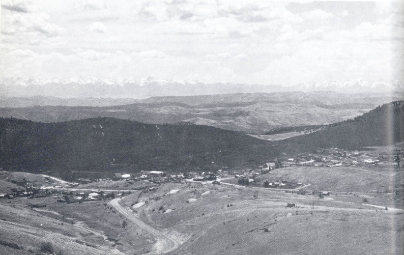
Cripple Creek, on the flanks of the Pikes Peak massif, has produced more than $400,000,000 worth of gold. The Sangre de Cristo Mountains are visible in the distance beyond the Arkansas River valley. (Jack Rathbone photo)
In 1890, two sheepherders stumbled on some richly mineralized rocks near Cripple Creek. A boom developed immediately, for the rocks contained both gold and silver. Since then, the area 91 has produced more than 2,000,000 ounces of silver and nearly 19,000,000 ounces of gold.
Cripple Creek has produced almost half of all the state’s gold and silver. The ores are located in or at the edge of a large mass of middle Tertiary volcanic rocks which form an elliptical basin or caldera several miles across. The caldera, surrounded by Precambrian gneiss and granite of the Pikes Peak massif, was probably formed by collapse of a volcanic center that had erupted through the older rock. The collapse shattered the rocks around the basin margin, and subsequent volcanic activity introduced mineral-rich solutions into the many faults and fissures produced by the collapse. Tellurides of gold, silver, and copper, as well as pyrite, sphalerite, galena, tetrahedrite, and other minerals, are characteristic.
Climax
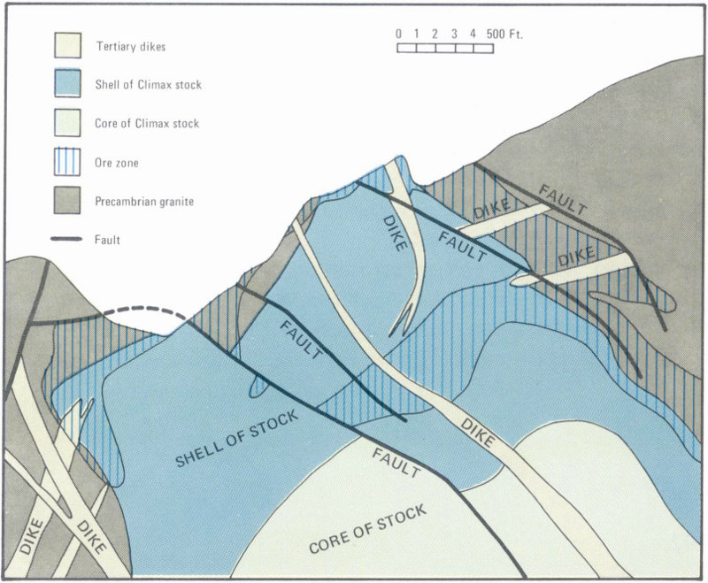
At Climax, the ore occurs scattered through the intrusive Climax Granite Porphyry and the intruded Idaho Springs Formation. Visitors can tour the surface workings during the summer months.
Molybdenum now ranks as the number one metal mined in Colorado. Over $105,000,000 of “moly” was mined here during 1969, almost all of it from the Climax Mine, the world’s largest single source of this metal. The Climax deposit is located high on the west slope of Ten Mile Range in central Colorado, about 92 100 miles southwest of Denver. It is in the central part of the Colorado mineral belt, near the Mosquito Fault, a prominent structural feature which extends about sixty miles along the north-south trend of the mountains. Rocks on both sides of this fault are intruded by Tertiary granite dikes, sills, and stocks. The Climax Mine is in a stock just east of the fault, near the axis of a broad anticline in Precambrian metamorphic rocks.
Ore minerals at Climax are molybdenite, huebnerite, and cassiterite; pyrite is recovered also for the manufacture of sulfuric acid. The ore is very low in metal content, containing only one-third of a percent of molybdenum, 0.005% tungsten trioxide, and 0.0001% tin. The great size of the ore body and efficient recovery by modern methods make Climax a profitable mine, however. Production has risen each year since the mine began operation.
Urad Mine near Berthoud Pass is a newly developed near-surface molybdenum mine similar to Climax. Nearby at the Henderson Mine the ore body is more than half a mile below the surface of the ground.
RADIUM, URANIUM, AND VANADIUM
Over a large area of the Plateau Province in western Colorado, Mesozoic sedimentary rocks are locally stained bright yellow, orange, or green. Such staining suggests mineralization, and radioactive compounds were recognized here before 1900. At that time, however, there was little or no market for them or for the vanadium frequently associated with them. When Marie Curie required radium for experiments with her newly discovered element, the raw materials were sent from western Colorado; by and large, though, production of radium from these ores was prohibitively expensive.
In 1905, vanadium was found to be effective in toughening steel. The Vanadium Corporation of America was formed to mine the Colorado ore. This company mines a rich zone in the Jurassic Entrada Sandstone, where vanadinite occurs with carnotite and other uranium ores. In the early days of vanadium mining, the uranium ores were discarded with other gangue materials; now, of course, uranium is produced from them.
Since 1945, uranium production has been an important Colorado industry; in 1969 about $17,500,000 worth was produced. Uranium occurs in the state in two very different situations. In the Plateau Province, where it was first discovered, it occurs in sedimentary rocks as patches of pitchblende, carnotite, and a greenish yellow mineral called schroekingerite. It is most abundant in the Triassic Chinle Formation and the Jurassic Entrada and Morrison Formations, where it was probably deposited by downward movement of rainwater from overlying uranium-rich Tertiary volcanic rocks. Concentrations of uranium often occur in or near organic matter such as coal, fossil bone, or petrified wood, so mines tend to be located along rock layers carrying abundant organic material.
Another type of uranium ore is found in the Mountain Province. Veins in Precambrian rocks of the Front Range and several other ranges contain pitchblende which seems to have been deposited by hot groundwater rising through broken and fissured Precambrian rocks. Often exceedingly rich, such ore is mined in the manner of most of Colorado’s metals. The Schwartzwalder Mine, a few miles northwest of Golden, has produced more ore of this type than any other mine in Colorado.
OIL, NATURAL GAS, AND OIL SHALE
Petroleum and natural gas have been found in large quantities in the Prairie and Plateau Provinces in Colorado, as well as in smaller quantities in North Park in the Mountain Province. They generally occur in porous sandstone and limestone layers, where they have been trapped by overlying finer-grained, less permeable layers in or near folds and faults.
Several oil and gas seeps were found along the mountain front shortly after the arrival of the earliest settlers. Near Canon City, on Oil Creek, a plaque commemorates the first production:
Oil Creek—site of the first oil well in the west—second place in the United States to produce petroleum from wells. In 1862 ... A. M. Cassedy drilled an oil well 50 feet deep. By February, 1863, production was one barrel a day. Later, several thousand gallons of petroleum were produced by primitive methods, and kerosene and lubricating oil were shipped by ox team as far as Denver and Santa Fe.
About twenty miles to the southeast, near Florence, the Cretaceous Pierre shales were drilled in 1876. Oil was found in a system of intersecting fractures and joints. Some of the early wells in the Florence field are still producing, making this Colorado’s oldest and longest producing field. It has yielded more than 10,000,000 barrels of oil.
Small quantities of oil have been produced near Boulder since about 1900, also from Pierre sandstones and shales. In this area, wells were located by “dowsing” or “witching,” as was fashionable at the time. Several old rigs can be seen near Boulder Reservoir. As at Florence, oil has been trapped in fractures of otherwise dense and impervious shale. Some gas is produced and is used by local farms.
More recently, oil was found far beneath the surface in the northern part of the Prairie Province. Here, in the Denver Basin, oil is produced from several levels in the Dakota Sandstone. The oil has accumulated in lenses of beach sand deposited along the shoreline of the Cretaceous sea. The general trend of the shoreline, and of the oil fields, is northeast-southwest. The shore appears to have been similar to Georgia’s present coastline: a swampy tidal zone separated from open sea by lagoons, sandy bars, and clean sand beaches.
Individual oil pools in the Denver Basin are small, but there are many of them; they lie nearly a mile below the surface, under much of Morgan and Logan Counties and adjacent parts of Nebraska. Exploratory and development drilling keeps total oil production at about 50,000 barrels a day. Oil and gas produced here is piped to Denver and other Colorado cities.
In southeastern Colorado, oil and gas occur in late Paleozoic limestones and sandstones similar to those which outcrop at the edge of the Wet Mountains. Prospecting by geophysical methods and by drilling has revealed several small, rich accumulations, one of which is thought to contain about 30,000,000 barrels of oil.
The Rangely field, in northwestern Colorado, is the most productive field in the state. Located in the northeastern part of the Uinta Basin, it is an outstanding example of an anticlinal field, where oil is trapped in a large, gentle dome. The shape of the dome shows up well on the surface; rock layers can be seen dipping outward in all directions from the town of Rangely. Oil was found by drilling on the crest of the dome. At first, oil was produced from fractures in the Cretaceous Mancos Shale at less than 1,000 feet depth. Later, deeper drilling showed that oil had also accumulated in the Permian Weber Sandstone, at 5,000 to 7,000 feet. At present this field is producing about 28,000 barrels of oil a day, but the figure is dropping each year as the field is depleted.
Oil and gas are produced in southwestern Colorado from the eastern edge of the Paradox Basin and the northern edge of the San Juan Basin. In the Paradox Basin, oil comes from Pennsylvanian limestone mounds or reefs. Production in the Colorado part of the basin has been at most a few thousand barrels per day; more is produced in adjacent Utah. In the San Juan Basin, gas and oil are trapped in thin porous layers of Cretaceous and Pennsylvanian sandstone, between impervious layers of shale. Most of the production is in New Mexico, although some oil comes from the Colorado part of the basin.
The greatest known potential oil resource in the world lies in the oil shales of western Colorado. The richest of these shales cover an area of 1,600 square miles north of the Colorado River, south of the White River, and just east of the Colorado-Utah line. The oil shales are part of the Tertiary Green River Formation, which extends over much of northwest Colorado, northeast Utah, and southern Wyoming. Oily material called kerogen is locked in these rocks, too solid to flow out of the fine pore spaces of the shale. To free it the shale must be mined, finely crushed, and heated until the kerogen converts to liquid oil. This is an expensive 96 process, and as yet production of petroleum from the oil shale has not been possible at a cost which will compete with production of oil and gas from wells. The United States Bureau of Mines, as well as a number of oil companies, have sought for more than fifty years to discover a less expensive method for extracting oil from the shale. No doubt at some time in the future a competitive technique will be developed, or a growing shortage of other oil will bring world prices to a level with which present production techniques can compete.
Oil and gas production in Colorado is decreasing at present, even though great efforts are being made to find new oil pools. Petroleum prospecting and wildcat drilling are carried out in as yet unproductive basins in the Plateau Province, in intermontane basins such as the San Luis Valley, and on the Plains. Known reserves will continue to provide the state with significant income for many years to come, and if oil shale recovery becomes profitable. Colorado’s hydrocarbons will become the most prominent of her commodities.
COAL
Coal resources of Colorado amount to about 60 billion tons. Only one per cent of this has been mined. Thousands of tons are now being produced daily from large mines in central, southern, and northwestern parts of the state.
Colorado’s coal deposits were formed during late Cretaceous and early Tertiary time, when seas were receding from this region and the land was rising. They represent accumulations of leaves and other plant material in swamps and flood plains similar to those now found in the delta of the Mississippi River and in the swamps of southeastern United States. Almost all Colorado coal is bituminous or soft coal.
Coal was recognized early in Colorado history by settlers along the mountain front, and was mined west and north of Denver in the 1860s. Several large underground mines still operate in this district, supplying local power plants, but production does not compare with that of the Walsenburg-Trinidad area in southern Colorado or the Hayden area in northwest Colorado.
The Walsenburg-Trinidad region, part of the Raton coal field, has produced coal since the building of the Santa Fe Railroad in the early 1870s. For many years coal from these mines moved the Santa Fe trains and many of the numerous smaller railroads 97 that served Colorado’s cities and mining camps. The location of the mines helped to determine the location of the Colorado Fuel and Iron Company smelter in Pueblo. Now, most southern Colorado coal is used to produce electric power. Many small mines, miles away from the power plant west of Trinidad, are deserted.
A large coal-burning power plant has recently been built between Hayden and Steamboat Springs, just west of the Yampa River. Here, some of the extensive coal deposits can be seen in road cuts along U. S. highway 40. Until conversion to diesel fuel became almost universal in North American railroads, mines of this district produced coal for locomotives.
In the heyday of the gold and silver mines, coal was also mined near Coalmont, in North Park, and Como, in South Park. Coal from these areas was used for fuel in nearby mining towns and ranches, and for the narrow-gauge railroads that penetrated the mountains here.
At Anthracite, near Crested Butte, high-grade anthracite coal was mined for a time. Identical in origin with other Colorado coal, the anthracite of this region was hardened by heat and pressures from Tertiary igneous intrusions forcing their way into local sedimentary rocks during post-Cretaceous mountain building.
A multitude of other coal camps are scattered about Colorado: Cokedale, Delcarbon, Coaldale, Roncarbo, Carbondale, and Cardiff stand out because of their suggestive names. These early small camps are, like their metal-mine cousins, largely deserted today.
CONSTRUCTION MATERIALS
Sand, Gravel, and Clay
Sand, gravel, and crushed rock rate high among geologic products in Colorado; more than $27,000,000 worth of these materials were produced in the state in 1969. Highway and construction activities have brought recent expansion in the number and size of quarries and gravel pits. Increasingly, Coloradoans are insisting that quarries and pits be excavated only where they will not mar the natural beauty of the landscape, and many old pits are now being filled in. Unfortunately, the scars left by some quarries—such as that on the Rampart Range near Colorado Springs—are difficult to erase.
Clay of good quality occurs in Cretaceous deposits in many parts of Colorado, most frequently in the Dakota or Laramie 98 Formations. In the area around Golden, the Coors Porcelain Company for many years mined clay for use in pottery and low temperature ceramic ware. Scars from this mining can be seen along the mountain front north and south of Golden, and deep clefts within the town, just west of Colorado School of Mines, testify to the amounts of clay that have been removed. Colorado clay is not pure enough to be used in high temperature ceramics, and the present use for it is in the manufacture of common tiles and bricks.
A recent development in Colorado is the use of Cretaceous Pierre shales in manufacturing lightweight aggregate for building. The shale is mined between Golden and Boulder, near Colorado highway 93. In the nearby plant, it is pulverized and then heated in a large rotating cylinder until the surface of each particle fuses. Then the particles are quickly cooled. The resulting product is much like cinder, light in weight and yet strong. It can be mixed with cement for use in construction work requiring a great strength-to-weight ratio, or made into concrete blocks.
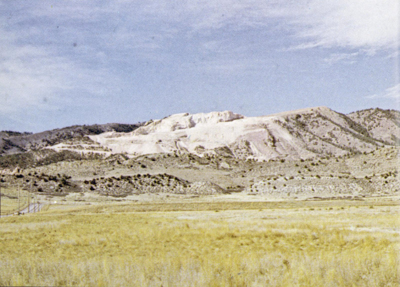
Quarrying of Paleozoic limestones and dolomites along the east flank of the Rampart Range northwest of Colorado Springs has badly defaced a prominent mountain backdrop. Recent seeding efforts by quarry operators are returning the exhausted part of the quarry to its original lightly vegetated condition, and hopefully, as the quarry is depleted, the scar will disappear. (John Chronic photo)
Stone
In Colorado, as in most parts of the world, building stone for local use is quarried locally. Two of the state’s stones, however—Yule Marble from the Crystal River Canyon, and Lyons Sandstone of the Front Range—have been more widely used.
The Yule Marble, or Yule Colorado Marble, was produced by metamorphism of Leadville Limestone in an area intruded by the Treasure Mountain Granite, thirty-five miles south of Glenwood Springs. This exquisite marble, which has graced many famous monuments and buildings (among them the Lincoln Memorial and the Tomb of the Unknown Soldier), is known for its almost uniform snowy whiteness and regular, fine crystallization. Although its beauty, massive character, and uniformity made it a sought-after ornamental stone, quarrying was economically marginal because of the remoteness of the site. In spite of this, nearly $7,000,000 worth of the marble was produced before the quarry closed in 1940.
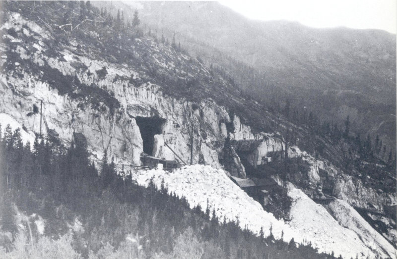
Pure white marble was quarried for many years at the Yule Colorado Marble Quarry, about three miles southeast of the village of Marble. (U. S. Geological Survey photo)
The Lyons area, north of Boulder, provides pink, hard, even-grained sandstone which splits readily into slabs or flagstones. These are used in the Denver-Boulder area for sidewalks and patios as well as for facing buildings. Quarries owned by the University of Colorado provide a constant supply of handsome facing material and flagstone for new university buildings, although in recent years the high cost of stone construction has limited its use on the campus.
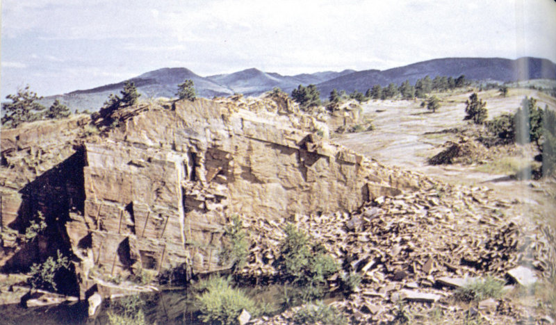
Lyons Sandstone is quarried near Lyons, Colorado. The salmon-colored sandstone splits along surfaces defined by slight differences in size and arrangement of the sand grains. (John Chronic photo)
Most of the buildings of the University of Colorado are faced with Permian Lyons Sandstone, which is widely used for buildings and flagstones throughout the Boulder-Denver area. The University Museum, shown here, was established in 1902, and contains over a million scientific specimens, including many Colorado fossils and minerals. Exhibits in the Hall of Earth portray Colorado’s geologic history. (Tichnor Bros. photo)
The Lyons Sandstone was deposited as beach and bar sand along the edge of a sea which lay east of the Front Range in Permian time. After deposition, the sand was deeply buried and compacted. Now tilted up along the Front Range uplift, it comes to the surface along the east side of the range. Only between Fort Collins and Boulder does the stone have the desirable combination of hardness, thin-beddedness, and color which makes it desirable for ornamental use. The pink color of the Lyons Sandstone is derived from iron oxides, mostly hematite, disseminated between the sand grains. Dendrites (often erroneously called fossil ferns or plants) ornament some slabs; they were formed by crystallization of manganese dioxide from groundwater as it slowly percolated through the rock.
Lime and Gypsum
Outcrops of the Cretaceous Greenhorn and Niobrara Limestones provide most of the cement materials in Colorado. A number of plants along the mountain front, including a completely automated and dust-free one near Lyons, provide the major population centers with millions of tons of cement each year.
Colorado is richly endowed with gypsum, useful in cement and plaster manufacture and for ornamental stone and sculpture. Along the eastern front of the mountains, gypsum occurs in the Triassic Lykins Formation; in the Mountain Province, it is abundant in Pennsylvanian sedimentary rocks. Particularly high-quality Pennsylvanian gypsum is quarried at the town of Gypsum, west of Eagle.
The Colorado portion of the Paradox Basin, in the Plateau Province, contains immense deposits of Pennsylvanian gypsum. Here, rocks near the surface have been pushed up into sharp northwest-trending faulted anticlines by upward movements of gypsum and salt from depths of several thousands of feet. The soluble salt and gypsum cores of these structures have been washed away more rapidly than the surrounding layers of sandstone and shale, leaving depressions such as Gypsum Valley, Paradox Valley, and Sinbad Valley, on the crests of the anticlines. Red and yellow Triassic sandstones and shales, especially the Chinle Formation and the Wingate Sandstone, dip away from these 102 valleys. Exploratory wells indicate that vast masses of salt and gypsum are present beneath the surface, and may extend to depths greater than 10,000 feet.
GEMS AND ORNAMENTAL STONES
More than thirty different gems and ornamental stones are known to occur in Colorado. Amazonstone, amethyst, garnet, tourmaline, aquamarine, topaz, lapis lazuli, quartz crystal, smoky and rose quartz, sapphire, several varieties of agate, zircon, and other attractive stones are gathered within the state, mainly in the Mountain Province. Turquoise is known at several places in the volcanic area of southern Colorado. Alabaster is mined along the northeastern mountain front near Fort Collins and Loveland. Localities of interest to gem hunters are described in Colorado Gem Trails and Mineral Guide, by Richard M. Pearl.
Gem Village, in southwestern Colorado on U. S. highway 160 between Durango and Pagosa Springs, is a favorite stopping place for tourists wishing to see or buy colorful and attractive Colorado stones such as petrified wood, agatized dinosaur bones, chalcedony, and jasper.
WATER
Although not all aspects of water and water supply are geologic, water is an important geologic agent, determining the shape of the surface, the distribution of minerals, and the location of caves. Water used in Colorado comes entirely from precipitation within the state, as all of Colorado’s rivers flow from Colorado outward toward the surrounding lower-elevation states.
Surface Water
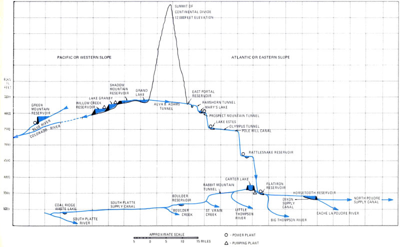
A cross section through the Front Range northwest of Denver shows the redistribution and use of western slope water in eastern Colorado through the Colorado-Big Thompson Project. This project has cost about $160,000,000, but it is repaying the investment many times over by providing electric power and increasing farm production.
Moisture carried by prevailing westerly or northwesterly winds falls primarily on Colorado’s western slope, although at some times of year precipitation may come from the northeast or southeast. West of the continental divide, where population is sparse, there is a surplus of water. East of the divide, where more than 90 per cent of the population lives, water is in desperately short supply. The high and largely unpopulated Mountain Province receives by far the greatest proportion of precipitation, while agricultural areas of the Prairie and Plateau Provinces receive 104 much less. Needless to say, the major problem involving water in Colorado is how to move it from areas where it is abundant to areas where it is needed.
In many parts of the state, complex water laws and complicated irrigation canals and water systems were developed soon after the area became settled. Gradually but inevitably, water resources have been transferred from the western slope to the eastern. However, such transfer must be undertaken with due regard for the rights of downstream users, notably California, Arizona, and New Mexico.
One of the largest water movement schemes in the state is the Colorado-Big Thompson Project. Water that otherwise would flow into the Colorado River is piped from Grand Lake through the Alva B. Adams tunnel under the high mountains of Rocky Mountain National Park, and into the Big Thompson drainage near Estes Park. It then travels through a series of reservoirs and tunnels into the South Platte River basin, where it is used for irrigation and household water. The water is pumped up the western gradient of this system by electric power produced as it flows down the eastern slope. Surplus electric power serves the Colorado-Wyoming area.
Another large project is the Denver Water Board’s Dillon Reservoir Project, in which western slope water collected at Dillon is pumped twenty-three miles under the continental divide through the Harold D. Roberts tunnel to the North Fork of the South Platte River for use by the city of Denver. The exit point of this tunnel can be seen a few miles west of Grant along U. S. highway 285. This project is continuously growing as Denver’s water needs mount.
In each of these projects, engineering geologists played a prominent part in locating dams and tunnels that would not leak or fail, and that could collect and transport a maximum amount of water during the high-runoff spring season for distribution through the rest of the year. Fortunately for geologists, the tunnels and bores necessary to the projects allowed them to learn a great deal about the structure of the interior of the high mountains, and helped to improve their interpretation of earth history in this most interesting region.
The necessity for storing irrigation water along the eastern mountain front has led to the creation of hundreds of new lakes in the region. Although water levels vary with the season, many of the lakes provide opportunities for water sports and recreation for the burgeoning inland population.
Two large dams have recently been built in western Colorado for another purpose: to control the flow of water in the Colorado River drainage basin. Electric power for western Colorado also comes from these dams. One of the dams is on the Gunnison River at Curecanti, upstream from the Black Canyon of the Gunnison National Monument, and the other is on the Frying Pan River near Ruedi. The latter was completed over the objections of geologists, who believed that the extensive gypsum deposits underlying the damsite would cause its failure. Cement pumped deep into the rocks in the vicinity has so far prevented serious rupture.
There is strong resistance by conservation groups to the construction of more dams on Colorado River drainage, primarily because the Colorado and its tributaries pass through many irreplaceable canyons, some of them parts of National Parks and Monuments, that are very much a part of our western heritage.
Groundwater
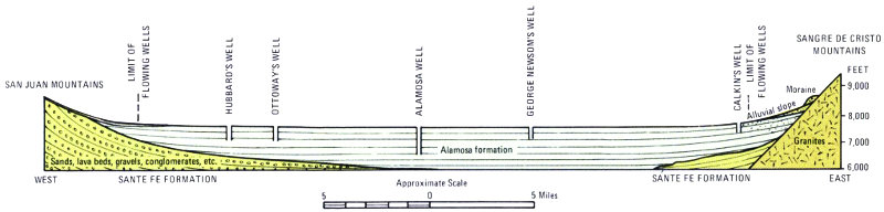
In the San Luis Valley, runoff from the San Juan and Sangre de Cristo Mountains sinks into layers of sand in the Alamosa Formation. Flowing along the sand layers toward the center of the valley, it provides artesian water for irrigation of valley farmlands.
- SAN JUAN MOUNTAINS
- LIMIT OF FLOWING WELLS
- HUBBARD’S WELL
- OTTOWAY’S WELL
- ALAMOSA WELL
- GEORGE NEWSOM’S WELL
- CALKIN’S WELL
- LIMIT OF FLOWING WELLS
- Moraine
- Alluvial Slope
- SANGRE DE CRISTO MOUNTAINS
- Sands, lava beds, gravels, conglomerates, etc.
- Alamosa formation
- Granites
- WEST
- SANTE FE FORMATION
- SANTE FE FORMATION
- EAST
Groundwater is extremely important to Colorado, especially in the Prairie Province and the San Luis Valley. Below these two areas lie a number of distinct and productive groundwater aquifers, several of them artesian. In Otero County, for example, there are five major aquifers: three separate Quaternary gravel deposits, the Cretaceous Dakota Sandstone, and the Cheyenne Sandstone Member of the Purgatoire Formation, also Cretaceous. All these aquifers are characterized by their high porosity and permeability, 106 which allow water to flow rapidly through them. Wells in the younger, shallower aquifers produce as much as 2,000 gallons per minute; those in the older, deeper aquifers produce about eighty gallons per minute, some of it with an artesian “head.”
The San Luis Valley supports intensive agriculture, made possible by a great artesian water supply. A thick series of soft interlayered clays and sands, the Alamosa Formation, slopes down toward the center of the basin from the surrounding mountains. Water entering the sandstone beds at the mountain edges flows through the sand layers held there by the impermeable clay beds. By the time it reaches the center of the valley, it has developed considerable hydrostatic head, and the water rises in wells without pumping. Unfortunately, both the irrigation water and the soils in the San Luis Valley are highly alkaline. Constant evaporation from the irrigated fields has concentrated the alkali near and on the surface, rendering some of the land less usable than it was originally.
Caves
Colorado has many caves, most of them carved by underground water in Paleozoic limestone. The Cave of the Winds at Manitou is the only one in the state which has been developed as a tourist attraction. It is in highly faulted Ordovician and Mississippian limestone near the mountain front, where the faulting, coupled with the high relief, has accelerated solution of the rock by allowing groundwater to percolate downward rapidly. The cavern was probably carved during the Pleistocene Ice Age, when surface water and groundwater were much more abundant than at present. Deposition of stalactites and stalagmites has occurred within the last few thousand years, as supplies and movement of water have decreased.
Spanish Cave, above timberline on Marble Mountain in the Sangre de Cristo Range, is probably the nation’s highest limestone cave. It is in thick folded and faulted Pennsylvanian reef limestone, at an elevation of over 12,000 feet. The cave has many intricate passageways branching from its main vertical tubes and channels.
Fulford Cave, south of Eagle, is in the Mississippian Leadville Limestone of the northern part of the Sawatch Range. Many other 107 caves are situated south of Fulford, near Woods Lake, where the limestone is widely exposed and highly dissected.
Fairy Cave, northeast of Glenwood Springs, is the best known of the many caverns in the Paleozoic limestones that form the southern flanks of the White River Plateau.
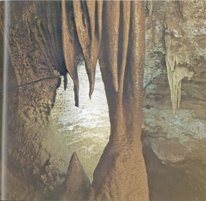
In Cave of the Winds near Manitou, Paleozoic limestones, cracked and tilted by uplift of the Front Range, have been honeycombed by ground water. Calcite stalactites hang from the ceiling, while stalagmites grow up from the floor. (Cave of the Winds Company photo)
In the Plateau Province another type of cave is formed not so much by groundwater as by weathering of the flat-lying alternating beds of massive resistant sandstone and less resistant, thinly 108 bedded mudstone and shale. Where the resistant layers are undermined, great arching caves develop. These are best observed at Mesa Verde National Park, where many of them once sheltered Indian communities. They can also be seen in Colorado National Monument and along the Colorado River and several of its major tributaries.
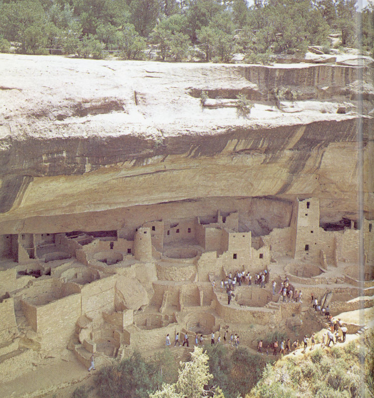
Along the edge at Mesa Verde, caves in Cretaceous Mesa Verde sandstone were used for shelter by Indians. Springs near the bases of the caves, which provided the Indian communities with water, probably contributed to the undermining of the sandstone cliffs. (Colorado Department of Highways photo)
Springs
The multitudes of mineral and hot springs in Colorado are a fascinating and interesting facet of the Mountain Province. Some are located along major faults, where the rocks are so broken and shattered that groundwater can move freely toward the surface. Colorado Springs, Manitou Springs, and Eldorado Springs are on the fault complex that forms the east edge of the Front Range. Glenwood, Juniper, Steamboat, and Poncha Springs are on well defined faults also.
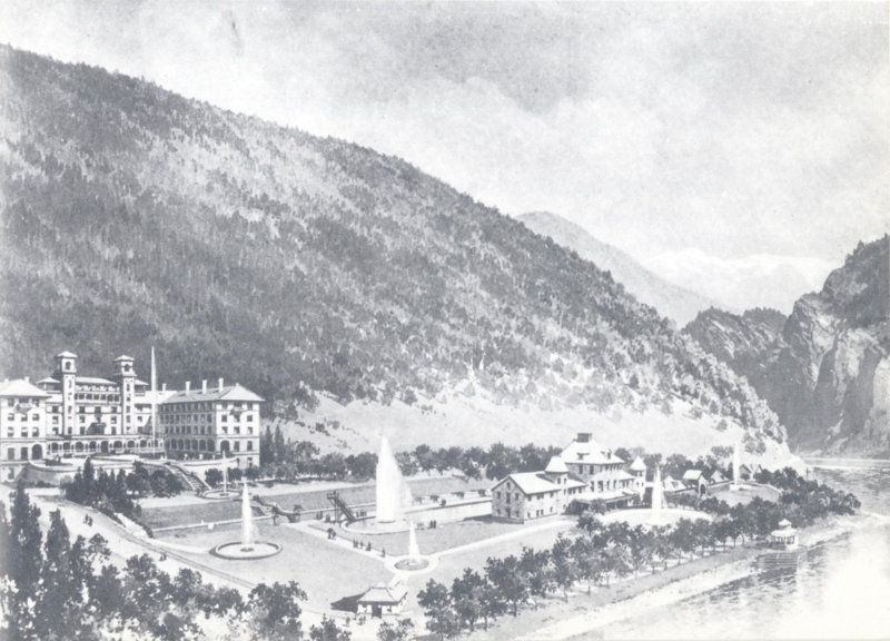
Glenwood Hot Springs flow from Pennsylvanian shales of the Belden Formation, where sedimentary layers are faulted by the sharp upward tilting against the south side of the White River Plateau. Behind the hotel and on the right can be seen the Mississippian Leadville Limestone, cut by the Colorado River. (From a painting by William H. Jackson, courtesy of Colorado State Archives and Public Record)
Many other springs do not seem to be controlled so strongly by faulting, but owe their presence to sources of volcanic or magmatic heat which exist near to the surface of the ground. Some springs of this type issue from Precambrian granite, or Cenozoic volcanic rock, while others flow from sedimentary rock layers. Waunita Hot Springs and Pagosa Springs, although near volcanic rocks, reach the surface through porous sandstones and shales of 110 Cretaceous age. Mt. Princeton Hot Springs comes from alluvium but its heat source is the intrusive igneous rock which makes up part of the adjacent mountain.
Springs of another general type are also present in Colorado where aquifers, generally sandstones, are dissected by erosion. These springs, usually not highly mineralized or warm, are most often found in the Plateau Province. Such springs are frequent at the bases of the great sandstone cliffs of Mesa Verde and Colorado National Monument.
Manitou’s carbonated springs, which attract many tourists, have their origin in the arrangement and nature of the rocks through which the water flows. Water from the Pikes Peak region, slightly acid from its contact with the granitic rock, flows into the Manitou limestone all along Ute Pass fault, which extends from Cheyenne Mountain northwest to Woodland Park. Descending through channels along the fault, the water becomes pressurized. Because of its pressure and its acid content, it partly dissolves the calcium carbonate of the limestone, and from then on carries carbon dioxide in solution. As the water comes to the surface at the low point of the fault exposure, near the west edge of Manitou, the pressure is released and the carbon dioxide effervesces, just as a bottle of soda water effervesces when the cap is removed.
ENVIRONMENTAL GEOLOGY
The preceding part of this chapter mentions many ways in which man’s destiny in Colorado has been shaped by geologic factors. Early Coloradoans settled near gold and silver placers, later ones near mines that produced ores of other metals, or in the towns that sprang up around the mills and smelters that processed these ores. Our present distribution of population is partly a heritage from these first settlements, partly a result of later discoveries of oil, gas, and radioactive minerals, and partly a response to the state’s extreme topographic variation, which controls and delineates agricultural areas and transportation routes.
In recent years, man has begun to appreciate the fact that he may benefit in other ways from knowledge about geology. A new geology has developed—environmental geology—which may be defined as the total of all geological conditions and influences affecting the life and development of man.
Environmental geology is a broad science, concerned not only with the location of cities and towns, but with the uses people make of the land and its economic products, and with the relationship between the geological character of the land and the present and future location of roads, dams, bridges, factories, homes, recreation facilities, sanitary land fills, and even sewage plants.
Two aspects of environmental geology which are particularly pertinent to Colorado’s residents are discussed below.
Landslides and slumping rock or earth are a frequent menace to Colorado’s development in the Mountain Province. Often activated by heavy rains or deep manmade cuts, they can cause—and have caused—much damage to roads, buildings, and other works of man.
The flanks of North and South Table Mountains, near Golden, are mantled by thick landslide debris; intermittent movement of the individual slides has repeatedly affected the railroad, irrigation ditches, and roads. As many as six different slides have moved within a single year. In one slide area, asphalt road material is estimated to be thirteen feet thick; successive layers of pavement have been laid one on top of another to keep the street up to grade.
Landslides and landslide-prone areas may not be obvious to the untrained eye. Each year buildings and roads are constructed on unsuitable rock and soil foundations, in places where some degree of land slip is almost inevitable. Building in such areas 112 is risky, but sometimes worth the risk; if condition are less than ideal, risks can be reduced by specialized types of construction.
Floods are a perennial threat to much of the state, because of the high relief of the drainage basins and the torrential nature of the spring and summer rainfall. Their damaging effects were realized early in Colorado’s history, when canyons were used as highways and railroad routes.
Colorado’s most expensive flood was probably the flood in the South Platte River basin south of Denver in 1965, which caused $508,000,000 worth of damage and drowned six people. The losses can be attributed to man’s failure to realize the significance of the South Platte drainage routes and flood plains. Homes, shopping centers, and many other buildings occupied—and still occupy, as of 1971—land that has been intermittently flooded for many years. The following description of this flood, by H. F. Matthai of the U. S. Geological Survey, may help to convey some warning to residents or potential residents of the South Platte valley and other river valleys in Colorado:
“The morning of June 16 was most pleasant, but conditions changed rapidly shortly before noon. A tornado touched ground 15 miles south southeast of Denver about 1 p.m. Within the next hour, another unroofed 30 homes in the little town of Palmer Lake, 40 miles south of Denver. About 2 p.m., a dense mass of clouds descended and concealed the top of Dawson Butte, 7 miles southwest of Castle Rock; and the little light remaining faded until it was dark black and frightening, according to some people. A nearby rancher’s wife described the intense quiet as awesome, but the calm did not last very long.
“The deluge began, not only near Dawson Butte, but also at Raspberry Mountain, 6 miles to the south, near Larkspur. The rain came down harder than any rain the local residents had ever seen, and the temperature dropped rapidly until it was cold. The quiet was shattered by the terrible roar of wind, rain, and rushing water. Then the thudding of huge boulders, the snapping and tearing of trees, and the grinding of cobbles and gravel increased the tumult. The small natural channels on the steep slopes could not carry the runoff; so water took shortcuts, following the line of least resistance. Creeks overflowed, roads became rivers, and fields became lakes—all in a matter of minutes.
“The flow from glutted ravines and from fields and hillsides soon reached East and West Plum Creeks. The combined flow in these creeks have been described as awesome, fantastic, and unbelievable; yet none of these superlatives seem adequate to 113 describe what actually occurred. Large waves, high velocities, crosscurrents, and eddies swept away trees, houses, bridges, automobiles, heavy construction equipment, and livestock. All sorts of debris and large volumes of sand and gravel were torn from the banks and beds of the streams and were dumped, caught, plastered, or buried along the channel and flood plains downstream. A local resident stated, ‘The banks of the creek disappeared as if the land was made of sugar.’
“The flood reached the South Platte River and the urban areas of Littleton, Englewood, and Denver about 8 p.m. Here the rampaging waters picked up house trailers, large butane storage tanks, lumber, and other flotsam and smashed them against bridges and structures near the river. Many of the partly plugged bridges could not withstand the added pressure and washed out. Other bridges held, but they forced water over approach fills, causing extensive erosion. The flood plains carried and stored much of the flood water, which inundated many homes, businesses, industries, railroad yards, highways, and streets.
“The flood peak passed through Denver during the night, and the immediate crisis was over by morning; but those in the inundated areas were faced with a Herculean task. The light of day revealed the nature of the destruction—mud in every nook and cranny, soggy merchandise, warped bowling alleys, drowned animals, the loss of irreplaceable possessions, to name a few types. The colossal cleanup job, which would take months, began.”
Hydrogeological studies by the U. S. Geological Survey and Corps of Engineers give knowledgeable estimates of flood danger for different populated areas of the state, and recommend that homes, roads, and other structures be placed above likely flood levels.
GLOSSARY
Alluvial fan. A cone-shaped mass of sediment built by rivers or streams as they issue from mountains onto more level ground.
Alluvium. Stream deposits formed in recent geologic time, composed of sand, gravel, and stones.
Ammonite. One of a large group of extinct mollusks related to the living chambered Nautilus. Ammonite shells, usually cone-shaped or coiled, are divided into many chambers by crenellated septa.
Angular unconformity. A surface separating tilted or folded layers of rock from overlying less disturbed layers.
Anticline. An upward fold or elongated arch in rock layers.
Aquifer. A rock layer that is water-bearing.
Artesian water. Groundwater that is under sufficient pressure to rise above the level at which it is encountered in a well. It does not necessarily rise completely to the surface.
Basalt. An extrusive igneous rock, fine-grained and dark colored, composed mainly of calcium-rich feldspar and the black mineral pyroxene.
Basement. A name commonly applied to metamorphic or igneous rocks underlying the sedimentary rock layers.
Batholith. A large body of intrusive igneous rock, 40 square miles or more in outcrop area, which extends downward to an unknown depth.
Bedrock. The solid rock which underlies soil, sand, clay, or other loose surface material.
Belemnite. The cigar-shaped internal shell of an extinct marine mollusk similar to a squid.
Brachiopod. One of a large group of marine shelled animals having two unequal, bilaterally symmetrical shells.
Bryozoa. A large group of tiny colonial marine animals that secrete calcareous or horny coverings in a great variety of shapes.
Caldera. A large basin-shaped depression caused by explosion or collapse around a volcanic center.
Cassiterite. A heavy, brown to brownish black mineral composed of tin and oxygen (SnO₂) that is an ore of tin.
Cephalopod. A marine mollusk with a head surrounded by tentacles. Squids and octupuses belong to this group, as do fossil forms having straight or coiled shells divided into numerous interior chambers.
Chalcopyrite. A reddish-gold colored ore of copper (CuFeS₂).
Cirque. A deep, steep-walled recess in a mountain, caused by glacial erosion at the head of a valley.
Concretion. A nodular or irregular concentration of minerals such as calcite or limonite, formed by precipitation of the mineral from groundwater around a nucleus.
Conglomerate. A rock containing coarse fragments of an older rock, usually as rounded water-worn stones or pebbles.
Conodont. One of a group of tiny dark brown tooth-like fossils thought to be dermal or dental parts of some extinct group of fish.
Diatreme. A volcanic vent or pipe drilled through rocks by the explosive energy of gas-charged molten rock, now containing igneous rock and often altered or unaltered fragments of the surrounding rock.
Dike. A vertical or nearly vertical sheet of igneous rock which cuts across the structure of adjacent rocks.
Diorite. An intrusive igneous rock composed of sodium-rich feldspar and dark minerals, with only small amounts of quartz.
Dip. The angle at which a layer of rock is inclined below the horizontal.
Dome. A roughly circular upfold in which the rock layers dip outward in all directions from the center.
Dowsing. Searching for underground water or ore with a divining rod, usually a forked stick supposed to locate spots where the desired substance may be found under the surface.
Echinoderm. One of a large group of marine invertebrate animals, most of which have pentagonal symmetry and a skeleton of many calcite plates. Many forms are spiny. The group includes starfish and sea urchins.
Evaporite. Chemical sediments precipitated when water (usually sea water) evaporates.
Extrusive rocks. Igneous rocks formed when molten rock material is ejected onto the surface. Synonymous with volcanic rocks.
Fault. A break in the rocks in which there has been displacement of the two sides relative to each other.
Fault block range. A mountain range bounded on two or more sides by faults.
Feldspar. A group of light-colored aluminum silicate minerals that are major constituents of igneous rocks. They contain potassium, sodium, and calcium in differing proportions.
Fold. A bend in rock layers.
Foraminiferida. One-celled marine animals with microscopic, perforated, many-chambered calcium carbonate shells, often called forams.
Fossil. The remains or traces of an animal or plant which has been preserved in the rock.
Fusulinid. One-celled marine animals (forams) with shells which look like a grain of wheat in shape and size, frequently abundant in Colorado Pennsylvanian rocks.
Galena. A heavy gray metallic mineral (PbS), often cubic in form, that is the most important ore of lead.
Gangue. Nonvaluable minerals occurring in veins with ore minerals.
Glaciation. Alteration of the earth’s surface by erosion and deposition by glacier ice.
Glacier. A body of ice originating on land by recrystallization of snow, and showing evidence of movement by flowing.
Gneiss. A coarse-grained metamorphic rock usually banded with streaks of darker, finer-grained rock.
Granite. An intrusive igneous rock consisting essentially of sodium or potassium feldspar and quartz, often speckled with dark-colored minerals.
Graptolite. Extinct marine organisms without known close living relatives, with small black sawblade-like chitinous hard parts preserved as fossils.
Hematite. A steel gray or metallic grayish black or reddish gray mineral (Fe₂O₃) that is an important ore of iron.
Hogback. A sharp-crested ridge formed by a resistant layer of steeply dipping rock.
Huebnerite. A heavy reddish brown mineral (MnWO₄) that is a major ore of tungsten.
Igneous rocks. Rocks formed by solidification from a molten state, either at the surface (extrusive) or below the surface (intrusive).
Intrusive rocks. Igneous rocks formed when molten rock material solidifies without reaching the surface.
Joint. A fracture in the rock, along which no discernible movement has taken place.
Kerogen. Solid bituminous material in oil shales.
Laccolith. A lens-shaped mass of igneous rock intruded into layered rocks.
Lava. Fluid or molten rock such as that which issues from a volcano.
Lode. A rock mass, often a vein, containing valuable minerals.
Massif. A mountainous mass that has relatively uniform geologic characteristics and which may embrace a number of peaks.
Mesa. A flat-topped mountain bounded on at least one side by a steep cliff.
Metamorphic rock. Rock formed by alteration of pre-existing rock, especially by great temperatures and pressures.
Mollusk. Any one of the large group of invertebrate animals which includes the snails, clams, octopuses, squids, and their extinct relatives.
Molybdenite. A soft bluish gray, metallic mineral (MoS₂) that is a major ore of molybdenum.
Monocline. A steplike fold in otherwise horizontal or gently dipping rock layers.
Moraine. An accumulation of unsorted rock material built up by the action of glacier ice.
Native gold. Gold occurring in nature uncombined with other elements.
Peneplain. A land surface worn down by erosion to a nearly flat or broadly undulating plain.
Petzite. A heavy black or steel gray metallic telluride ore of gold and silver (Ag₃AuTe₂).
Placer. A sand or gravel deposit containing particles or nuggets of gold or other heavy valuable minerals.
Plateau. An elevated, comparatively flat surface of land, usually larger than a mesa, sometimes composed of many mesas, and often dissected by deep stream valleys.
Porphyry. An igneous rock, usually intrusive, which contains conspicuous large crystals in a fine-grained matrix.
Pyrite. A brass-yellow metallic mineral (FeS₂) that is an important source of sulfur. It is commonly known as fool’s gold.
Reef. A moundlike limestone structure built in the sea by sedentary organisms such as corals.
Rhyolite. A light-colored volcanic rock with quartz and feldspar as the principal constituents.
Schist. A metamorphic rock characterized by parallel orientation of flat-grained minerals like mica.
Sedimentary rocks. Rocks formed of fragments of other rock transported by wind or water, or formed by precipitation from solution.
Sphalerite. An amber-yellow to black mineral (ZnS) that is an important ore of zinc.
Stalactite. A cylindrical or conical deposit of calcite hanging from the roof of a cavern, formed by evaporation of water droplets containing calcium carbonate.
Stalagmite. Columns or ridges of calcite rising from the floor of a cavern, formed by water containing calcium carbonate dripping from a stalactite.
Stock. A mass of igneous intrusive rock that covers less than 40 square miles, has steep sides, and extends to an unknown depth.
Tennantite. A metallic gray mineral that contains copper, iron, and arsenic, and is an ore of copper.
Tetrahedrite. A brittle, dark gray to black, metallic mineral containing copper, iron, zinc, and silver.
Trilobite. One of a primitive group of extinct marine crustaceans, related to crabs and lobsters, having segmented bodies divided by longitudinal grooves into three lobes.
Unconformity. A surface separating layers of rock, formed by a period of nondeposition or erosion.
Vein. A crack or fissure filled with mineral material, often with valuable ore minerals.
SUGGESTED READING
There are thousands of scientific articles and books on Colorado geology, and many new ones appear each year. Following is a selection of books and booklets which we believe will be most useful and interesting in extending your knowledge of the state’s geology.
Donnell, John R., editor, 1960, GEOLOGICAL ROAD LOGS OF COLORADO. Rocky Mountain Association of Geologists, Denver. Itineraries for a number of geological trips along Colorado highways and byways.
Eckel, Edwin B., 1961, MINERALS OF COLORADO, A 100-YEAR RECORD. U. S. Geological Survey Bulletin 1114.
Emmons, S. F., Cross, Whitman, and Eldridge, G. H., 1896, GEOLOGY OF THE DENVER BASIN IN COLORADO. U. S. Geological Survey Monograph 27. The classic early treatment of the surface geology around Denver, with many historic illustrations.
Hansen, Wallace R., 1965, THE BLACK CANYON OF THE GUNNISON TODAY AND YESTERDAY. U. S. Geological Survey Bulletin 1191. A readable account of this unusual national monument near Montrose.
Hansen, Wallace R., 1969, THE GEOLOGIC STORY OF THE UINTA MOUNTAINS. U. S. Geological Survey Bulletin 1291. The eastern part of this range is in Colorado.
Henderson, C. W., 1926, MINING IN COLORADO, A HISTORY OF DISCOVERY, DEVELOPMENT AND PRODUCTION. U. S. Geological Survey Professional Paper 138.
Lee, W. T., 1917, THE GEOLOGIC STORY OF THE ROCKY MOUNTAIN NATIONAL PARK, COLORADO. U. S. National Park Service Publication. An old report, not adequately superseded.
Lovering, T. S., and Goddard, E. N., 1950, GEOLOGY AND ORE DEPOSITS OF THE FRONT RANGE, COLORADO. U. S. Geological Survey Professional Paper 223. A comprehensive study of mineral-bearing areas in the Front Range.
Lohman, S. W., 1965, THE GEOLOGIC STORY OF COLORADO NATIONAL MONUMENT. Colorado and Black Canyon Natural History Association, Grand Junction.
Pearl, Richard M., 1956, NATURE AS SCULPTOR: A GEOLOGIC INTERPRETATION OF COLORADO SCENERY. 120 Denver Museum of Natural History Popular Series No. 6, Revised Edition.
Pearl, Richard M., 1969, EXPLORING ROCKS, MINERALS, FOSSILS IN COLORADO. Swallow Press, Revised Edition.
Pearl, Richard M., 1971, COLORADO GEM TRAILS AND MINERAL GUIDE. Swallow Press, 3rd Edition.
Powell, John Wesley, 1876, REPORT ON THE GEOLOGY OF THE EASTERN PORTION OF THE UINTA MOUNTAINS AND A REGION OF COUNTRY ADJACENT THERETO. U. S. Geological and Geographical Survey of the Territories. One of the earliest accounts of geology in Colorado, written by the explorer of the Colorado River and the father of the U. S. Geological Survey.
Rabbit, Mary C., and others, 1969, THE COLORADO RIVER AND JOHN WESLEY POWELL. U. S. Geological Survey Professional Paper 669. A resumé of part of Powell’s work and a good discussion of the geologic history of the entire Colorado River, which begins near Grand Lake.
Richmond, Gerald M., 1965, GLACIATION OF THE ROCKY MOUNTAINS. A part of THE QUATERNARY OF THE UNITED STATES, Princeton University Press. A summary of current knowledge of glaciation in Colorado and surrounding areas.
Rodeck, Hugo G., editor, 1964, NATURAL HISTORY OF THE BOULDER AREA. University of Colorado Museum Leaflet No. 13. Contains articles on geology and biology.
Untermann, G. E., and Untermann, B. R., 1954, GEOLOGY OF DINOSAUR NATIONAL MONUMENT AND VICINITY, UTAH—COLORADO. Utah Geological and Mineralogical Survey Bulletin 42. A detailed study of the eastern Uinta Mountains.
Weimer, Robert J., and Haun, John D., editors, 1960, GUIDE TO THE GEOLOGY OF COLORADO. Geological Society of America, Rocky Mountain Association of Geologists, and Colorado Scientific Society, Denver. A concise summary of many aspects of Colorado geology, this guide includes several geological itineraries and many reference listings.
Wolle, Muriel Sibell, 1949, STAMPEDE TO TIMBERLINE, Sage Books. An excellent account of early mining activity in the state, with many fine drawings of the early settlements.
INDEX
A B C D E F G H I J K L M N O P Q R S T U V W X Y Z
- A
- Abrams Mountain, 87
- Alamosa, 35
- Alamosa Formation, 67, 105, 106
- Alma, 78
- Ancestral Rocky Mountains, 44, 45
- Animas River, 58, 86
- Ankareh Formation, 52
- Antero Junction, 21
- Anthracite, 97
- Arapahoe Conglomerate, 60
- Arapaho Glacier, 70, 71
- Arkansas Hills, 21
- Arkansas Mountain, 79
- Arkansas River, 3, 22, 35, 90
- Arkansas Valley, 21
- Aspen, Front., 1, 22, 35, 50, 74, 77, 78, 88-89
- Aspen Mountain, 23, 88
- Avon, 22
- B
- Battlement Mesa, 62
- Belden Formation, 44, 109
- Benton Shale, 57
- Berthoud Pass, 12, 92
- Big Thompson Canyon, 12, 71
- Big Thompson River, 69, 103, 104
- Black Canyon of the Gunnison, 36, 37, 44, 71, 105
- Black Hawk, 14, 77, 78, 79, 80
- Blue River, 103
- Book Cliffs, 29
- Boulder, 8, 14, 33, 45, 47, 48, 50, 71, 74, 75, 94, 98, 99, 100, 101
- Boulder County, 78, 79
- Boulder Creek, 1, 15, 71, 103
- Boulder Creek Granite, 14, 33, 35
- Boulder Reservoir, 103
- Breckenridge, 1, 78, 83-84
- Bross, Mt., 21
- Buena Vista, 22
- Buffalo Peaks, 21
- Building stone, 24, 48, 50, 99-101
- C
- Cache la Poudre River, 66, 103
- Cambrian, 7, 34, 39
- Camp Bird, 78, 88
- Canon City, 3, 11, 16, 52, 53, 75, 94
- Canon City Embayment, 16
- Carbondale, 97
- Carboniferous, see Mississippian, Pennsylvanian
- Cardiff, 97
- Carmel Formation, 52
- Carter Lake, 103
- Castle Creek, 88
- Castle Rock, 8, 61, 112
- Castle Rock Conglomerate, 60
- Cave of the Winds, 106, 107
- Caves, 31, 106-108
- Cenozoic (see also Tertiary, Quaternary), 7, 16, 18, 26, 28, 29, 59-73, 109
- Central City, 1, 14, 74, 77, 78, 80
- Chaffee Formation, 42
- Cherry Creek, 1
- Cheyenne Mountain, 14, 15, 110
- Cheyenne Sandstone, 105
- Chinle Formation, 51, 52, 93, 101
- Clay, 75, 97-99
- Clear Creek, 1, 71, 80
- Climax, 21, 78, 91-92
- Climax Granite Porphyry, 91, 92
- Coal, 23, 75, 96-97
- Coal Creek, 14, 15
- Coal Creek Quartzite, 33
- Coaldale, 97
- Coalmont, 97
- Cokedale, 97
- Collegiate Range, 22
- Colorado National Monument, 29, 31, 44, 51, 108
- Colorado River, 3, 20, 21, 28, 29, 35, 39, 103, 104, 105, 108, 109
- Colorado Springs, 14, 15, 35, 37, 48, 97, 98, 109
- Columbia, Mt., 22
- Como, 78, 97
- Construction materials, 97-102
- 122
- Copper, 74, 75, 80, 81, 83, 89, 91
- Creede, 65, 78, 89-90
- Crested Butte, 24, 97
- Cretaceous, 7, 12, 20, 23, 29, 30, 53, 56-58, 94, 95, 97, 98, 101, 105, 108, 110
- Cripple Creek, 1, 74, 77, 78, 90-91
- Cross Mountain, 26, 29
- Crystal River, 24, 99
- Culebra Range, 17
- Curecanti, 105
- Curtis Formation, 52
- D
- Dakota Formation, 12, 51, 53, 56, 94, 97, 105
- Dawson Arkose, 60
- Dawson Butte, 112
- Delcarbon, 97
- Democrat, Mt., 21
- Denver, 3, 8, 14, 33, 35, 37, 45, 47, 48, 52, 53, 60, 74, 83, 94, 96, 99, 100, 104, 112, 113
- Denver Basin, 8, 75, 94, 95
- Denver Formation, 60, 62
- Devonian, 7, 42-43, 83
- Dillon, 104
- Dinosaur National Monument, 27, 53, 55
- Durango, 25, 28, 35, 47, 58, 78, 85, 102
- Dyer Dolomite, 42
- E
- Eagle, 47, 101, 106
- Eagle River, 22, 47
- Edwards, 22
- Elbert, Mt., 22
- Eldorado Springs, 109
- Elk Mountains, 24, 69
- Empire, 1, 78, 81
- Englewood, 113
- Entrada Sandstone, 51, 93
- Environmental geology, 111-113
- Eocene, 64
- Estes Lake, 103
- Estes Park, 69, 104
- Evans, Mt., 3, 12
- F
- Fairplay, 78, 84-85
- Fairy Cave, 107
- Flattop Mountain, 19
- Floods, 112-113
- Florence, 74, 94
- Florissant Fossil Beds National Monument, 65
- Fort Carson, 15
- Fort Collins, 35, 101, 102
- Fountain Formation, 12, 14, 45, 47, 48
- Fox Hills Sandstone, 58
- Fremont Limestone, 40, 41
- Frisco, 21
- Front Range, 11-16, 33, 35, 44, 50, 51, 52, 56, 60, 61, 68, 69, 70, 71, 93, 99, 101, 103, 107, 109
- Frying Pan River, 105
- Fulford, 107
- Fulford Cave, 106
- G
- Garden of the Gods, 4, 14, 15, 47, 48
- Garfield, Mt., 30
- Gas, natural, 1, 28, 75, 94-96
- Gems, 75, 102
- Gem Village, 102
- Georgetown, 78, 81
- Gilman, 21
- Gilpin County, 78
- Glen Eyrie Formation, 44
- Glenwood Canyon, 37, 39
- Glenwood Springs, 24, 29, 35, 99, 107, 109
- Gold, 1, 22, 29, 74, 75, 77-91
- Golden, 8, 14, 62, 74, 78, 83, 93, 98, 111
- Gold Hill, 1, 74, 78, 79
- Gore Creek, 47
- Gore Pass, 19, 20
- Gore Range, 20-21, 35, 69
- Gore Range-Eagle’s Nest Wilderness Area, 20, 21
- Granby, 20, 62
- Granby Lake, 103
- Grand Hogback, 28, 29
- Grand Junction, 29, 30, 35, 55
- Grand Lake, 12, 69, 103, 104
- Grand Mesa, 35, 62
- Grand Valley, 25
- Gravel, 75, 97-99
- Great Sand Dunes National Monument, 17, 18, 73
- 123
- Green River, 27, 103
- Green River Basin, 4
- Green River Canyon, 31
- Green River Formation, 64, 95-96
- Greenhorn Formation, 101
- Greenhorn Peak, 16
- Groundwater, 76, 105-106
- Gunnison, 35
- Gunnison, Black Canyon of the, 36, 37, 44, 71, 105
- Gunnison River, 35, 36, 37, 105
- Gypsum (mineral), 22, 30, 75, 101-102
- Gypsum (town), 47, 101
- Gypsum Valley, 30, 47, 101
- H
- Hahn’s Peak, 19
- Harding Sandstone, 40, 41
- Harvard, Mt., 22
- Hayden, 96, 97
- Hayden Pass, 17
- Hermosa Formation, 45, 47
- Hidden Valley, 69
- Horseshoe Amphitheater, 85
- Horseshoe Park, 69
- Horsetooth Reservoir, 103
- Huerfano Basin, 35, 61
- I
- Ice Age, see Pleistocene
- Iceberg Lake, 66
- Idaho Springs, 14, 78, 80
- Idaho Springs Formation, 33, 92
- Independence Pass, 22
- Iron, 1, 17, 74
- Ironton, 78, 88
- L
- La Junta, 8, 35
- Lake City, 77, 78
- Lake County, 77
- Lamar, 8
- Landslides, 111-112
- La Plata Mountains, 26
- Laramide Orogeny, 59, 60
- Laramie Formation, 57, 58, 97
- Larkspur, 112
- La Veta Pass, 17, 18, 37
- Lead, 74, 75, 80, 81, 82, 83, 85, 86, 89
- Leadville, 1, 22, 77, 78, 82-83
- Leadville Limestone, 43, 44, 83, 88, 99, 106, 109
- Lime, 75, 101
- Lincoln, Mt., 21
- Lincoln Porphyry, 21
- Lipalian Interval, 7, 36, 39
- Littleton, 113
- Logan County, 95
- Longs Peak, 3, 11, 12, 68
- Loveland, 14, 102
- Loveland Pass, 12
- Lykins Formation, 12, 51, 52, 101
- Lyons, 14, 49, 99, 100, 101
- Lyons Sandstone, 12, 48, 49, 50, 99, 100, 101
- M
- Magnolia, 79
- Mancos Shale, 30, 95
- Manitou, 39, 106, 107, 110
- Manitou Formation, 40, 41, 110
- Manitou Springs, 109
- Marble, 24, 99
- Marble Mountain, 106
- Maroon Bells, Front., 24, 50
- Maroon Creek, 24
- Maroon Formation, 50
- Mary’s Lake, 103
- Massive, Mt., 82
- McDermott Formation, 58
- Mesa de Maya, 8, 35, 62
- Mesa Verde, 28, 29, 35
- Mesa Verde Formation, 30, 58, 108
- Mesa Verde National Park, 31, 71, 108
- Mesozoic (see also Triassic etc.), 7, 10, 11, 12, 14, 15, 26, 28, 51-58, 60, 93
- Mestas, Mt., 17
- Middle Park, 4, 16, 35, 61
- Million Dollar Highway, 87, 88
- Mills Lake, 68
- Milner Pass, 66
- Minturn, 39
- Minturn Formation, 45, 46, 47
- Miocene, 66, 67, 87
- 124
- Mississippian, 6, 7, 43-44, 83, 106, 109
- Moenkopi Formation, 52
- Molas Formation, 44
- Molas Lake, 25
- Molybdenum, 1, 74, 75, 76, 77, 91-92
- Monarch Pass, 23
- Morgan County, 95
- Morrison, 53, 54, 55
- Morrison Formation, 12, 36, 51, 53, 55, 93
- Mosca Pass, 17, 73
- Mosquito Pass, 85
- Mosquito Range, 21, 22, 35, 39, 69
- Mountain Province, 3, 4, 10-27, 35, 46, 93, 94, 101, 102, 103, 109, 111
- Mt. Bross, 21
- Mt. Columbia, 22
- Mt. Democrat, 21
- Mt. Elbert, 22
- Mt. Evans, 3, 12
- Mt. Garfield, 30
- Mt. Harvard, 22
- Mt. Lincoln, 21
- Mt. Massive, 82
- Mt. Mestas, 17
- Mt. Princeton, 22
- Mt. Princeton Hot Springs, 22, 110
- Mt. Sneffels, 87, 88
- Mt. Sopris, 24
- Mt. Yale, 22
- Mt. Zirkel, 19
- Music Pass, 17, 73
- N
- Navajo Sandstone, 52
- Nederland, 78, 79
- Needle Mountains, 26
- Niobrara Formation, 57, 101
- North Park, 4, 16, 35, 58, 61, 94, 97
- O
- Oil, 1, 29, 30, 75, 76, 94-96
- Oil Creek, 94
- Oil shale, 95-96
- Oligocene, 66, 67
- Ordovician, 7, 40-41, 83, 106
- Orient, 17
- Oro, 82
- Otero County, 105
- Ouray, 4, 25, 26, 34, 42, 78, 87-88
- Ouray Formation, 42
- P
- Pagoda Mountain, 68
- Pagosa Springs, 102, 109
- Paleozoic (see also Cambrian etc.), 7, 10, 11, 12, 14, 15, 17, 21, 22, 24, 26, 27, 28, 30, 34, 37, 38-50, 60, 64, 77, 95, 98, 106, 107
- Paradox Basin, 4, 47, 95, 101
- Paradox Valley, 30, 101
- Park Range, 19-20, 35, 69
- Parting Sandstone, 42
- Pawnee Buttes, 9, 66, 67
- Peak Province, see Mountain Province
- Peat, 75
- Pennsylvanian, Front., 6, 7, 14, 23, 44-47, 48, 50, 83, 95, 101, 106, 109
- Permian, Front., 7, 23, 48-50, 95, 99, 100, 101
- Petroleum, 1, 29, 30, 75, 76, 94-96
- Phosphoria Formation, 50
- Piceance Basin, 29
- Pierre Formation, 57, 94, 98
- Pikes Peak, 3, 4, 11, 12, 15, 65, 90, 91, 110
- Pikes Peak Granite, 4, 14, 33, 36
- Plains Province, see Prairie Province
- Plateau Province, 3, 4, 9, 28-31, 35, 46, 71, 75, 93, 94, 96, 101, 103, 107, 110
- Platte River, 3
- Pleistocene, 7, 8, 25, 59, 68-73, 105, 106
- Plum Creek, 112
- Poncha Springs, 109
- Prairie Province, 3, 8-10, 12, 35, 66, 72, 75, 94, 96, 103, 105
- Precambrian, 7, 10, 11, 14, 15, 16, 17, 19, 20, 21, 26, 33-37, 40, 60, 64, 68, 77, 87, 91, 92, 93, 109
- Princeton, Mt., 22
- Pueblo, 23, 97
- Pumice, 75
- 125
- Purgatoire Formation, 105
- Pyrites, 75
- R
- Rabbit Ears Pass, 19
- Rabbit Ears Range, 20, 35, 62
- Radium, 93
- Rampart Range, 15, 97, 98
- Rangely, 29, 95
- Raspberry Mountain, 112
- Rattlesnake Reservoir, 103
- Raton Basin, 61
- Raton Pass, 61
- Red Cliff, 39
- Red Mountain, 88
- Red Mountain Creek, 88
- Red Rocks Park, 14, 37, 47
- Redstone, 24
- Rico, 26
- Rico Range, 26
- Rifle, 64
- Rio Grande, 35
- Roan Plateau, 28, 29, 35
- Rocky Mountain National Park, 11, 12, 66, 68, 71, 104
- Roncarbo, 97
- Royal Gorge, 37, 71
- Ruedi, 105
- S
- St. Mary’s Glacier, 71
- Salida, 17, 21, 35
- Salina, 79
- Sand, 75, 97-99
- Sangre de Cristo Range, 10, 17-18, 35, 47, 61, 69, 73, 90, 105, 106
- San Juan Basin, 95
- San Juan County, 78
- San Juan Formation, 88
- San Juan Mountains, 4, 25-26, 35, 52, 65, 69, 77, 85, 86, 87, 88, 105
- San Luis Valley, 4, 35, 44, 61, 67, 73, 96, 106
- San Miguel Range, 26
- Santa Fe Formation, 67, 105
- Sawatch Range, 22-23, 35, 39, 69, 82, 106
- Sawatch Sandstone, 34, 39, 40
- Sedalia, 61
- Shadow Mountain Reservoir, 103
- Sierra Blanca, 17, 18
- Silurian, 7, 42
- Silver, 22, 74, 77-91
- Silver Cliff, 16, 77, 78
- Silver Plume, 78, 81
- Silver Plume Granite, 33, 35
- Silverton, 4, 26, 74, 77, 78, 85-86, 88
- Sinbad Valley, 101
- Sneffels, Mt., 87, 88
- Sopris, Mt., 24
- South Park, 4, 16, 21, 35, 61, 65, 84, 97
- South Platte River, 1, 3, 35, 85, 103, 104, 112, 113
- Spanish Cave, 106
- Spanish Peaks, 10, 18, 62
- Specimen Mountain, 66
- Springs, 17, 22, 109-110
- Steamboat Springs, 97, 109
- Summit County, 77
- Sunshine, 79
- Sunshine Peak Rhyolite, 87
- Swandyke Gneiss, 33
- T
- Table Mountain, 8, 62, 111
- Telluride, 26, 74, 77, 78
- Tenmile Gorge, 21
- Tenmile Range, 21, 91
- Tertiary, 7, 15, 20, 21, 25, 26, 29, 59-67, 73, 77, 83, 87, 88, 89, 90, 91, 92, 93, 95, 96, 97
- Tin, 75
- Tincup, 22, 77, 78
- Trail Ridge Road, 12, 66
- Treasure Mountain Granite, 99
- Triassic, 7, 23, 51-52, 93, 101
- Trinidad, 8, 61, 96, 97
- Trout Creek Pass, 21, 22
- Tungsten, 1, 74, 75, 79
- Tyndall Glacier, 71
- U
- Uinta Basin, 4, 29, 64, 75, 95
- Uinta Mountain Formation, 26
- Uinta Mountains, 4, 10, 26-27, 29, 35, 37, 64
- Uncompahgre Gorge, 87
- 126
- Uncompahgre Plateau, 29, 35, 44
- Uncompahgre Quartzite, 87
- Urad Mine, 92
- Uranium, 1, 29, 80, 93
- W
- Walden, 20
- Walsenburg, 35, 61, 96
- Ward, 78
- Water, 76, 103-110
- Waunita Hot Springs, 109
- Weber Sandstone, 95
- West Elk Mountains, 24, 35, 69
- Wet Mountains, 16, 35, 61, 95
- Wet Mountain Valley, 35
- Whiskey Creek Pass, 17
- White River, 35, 95
- White River Formation, 66
- White River Plateau, 28, 29, 35, 43, 107, 109
- Williams Canyon, 37, 39
- Willow Creek Pass, 20
- Willow Creek Reservoir, 103
- Wingate Formation, 51, 52, 101
- Wolcott, 22, 47
- Wolford Mountain, 60
- Woodland Park, 110
- Woods Lake, 107

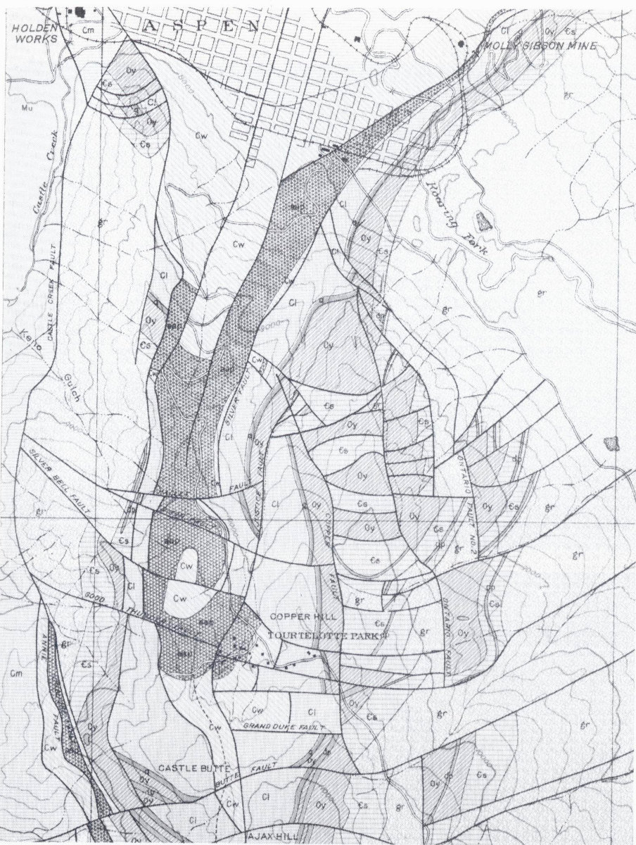