
.
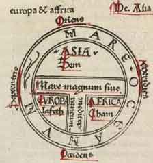
Earliest printed example of a classical T and O map (by Guntherus Ziner, Augsburg, 1472), illustrating the first page of chapter XIV of the Etymologiae.
A T and O map or T-O map, is a type of medieval world map, representing the physical world as described by the 7th century scholar Isidore of Seville in his Etymologiae (chapter 14, de terra et partibus):
Orbis a rotunditate circuli dictus, quia sicut rota est [...] Undique enim Oceanus circumfluens eius in circulo ambit fines. Divisus est autem trifarie: e quibus una pars Asia, altera Europa, tertia Africa nuncupatur.
"The world is called 'round' after the roundness of a circle, because it is like a wheel [...] Because of this, the Ocean flowing around it is contained in a circular limit, and it is divided in three parts, one part being called Asia, the second Europe, and the third Africa."
Isidore therefore assumes a flat earth, shaped "like a wheel". This is in opposition to the spherical earth that had been the mainstream assumption at least since Aristotle, who had divided the spherical earth in five zones: The poles were freezing and the equatorial zone was so hot, no one could pass through it. In between the poles and the middle hot zone lay two temperate zones. I.e. the T is the Mediterranean, dividing the three continents, Asia, Europe and Africa, and the O is the encircling Ocean. Jerusalem was generally assumed to lie at the center of the circle.
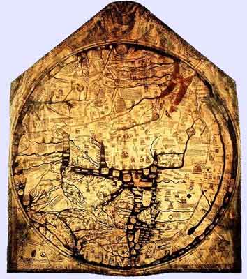
The Hereford Mappa Mundi, about 1300, Hereford Cathedral, England. A classic "T-O" map with Jerusalem at center, east toward the top, Europe the bottom left and Africa on the right.
The T-O map remained a customary representation, even after the spherical shape of the earth had become common knowledge once again in Europe, at the latest in the 11th century. It was presumably tacitly considered a convenient projection of the inhabited parts, the northern temperate clime. Since the southern temperate clime, the antipodes were considered uninhabited, or unattainable (Saint Augustine had considered the proposition of reaching the southern hemisphere "absurd"), there was no need to depict them on a world map.
The inhabited world of the northern land mass thus mapped consisted of the three continents of Africa, Asia and Europe, with the navel of the world, umbelicus mundi, always at Jerusalem. Asia was typically the size of the other two continents combined. The land on the map is divided into three parts by a "T" shape in which Asia occupies the top of the T area, Europe the bottom left and Africa the bottom right, within the "O" of the Ocean surrounding and separating them. Thus, North is to the left and South is to the right.
The T and O style of map is sometimes called a Beatine map or a Beatus map because one of the earliest known representations of this sort is attributed to Beatus of Liébana, an 8th century Spanish monk. The map appeared in the prologue to his twelve books of commentaries on the Apocalypse.
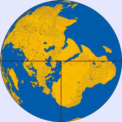
A "T-O" map made with modern cartography.
This qualitative and conceptual type of medieval cartography could yield extremely detailed maps in addition to simple representations. The earliest maps had only a few cities and the most important bodies of water noted. The four sacred rivers of the holy land were always present. More useful tools for the traveller were the itinerary, which listed in order the names of towns between two points, and the periplus that did the same for harbours and landmarks along a seacoast.
Later maps of this same conceptual format featured many rivers and cities of Eastern as well as Western Europe, and other features encountered during the Crusades. Decorative illuminations were also added in addition to the new geographic features. The most important cities would be represented by distinct fortifications and towers in addition to their names, and the empty spaces would be filled with mythical creatures.
References
Crosby, Alfred W. The Measure of Reality : Quantification in Western Europe, 1250-1600. Cambridge: Cambridge University Press,1996
| Ancient Greece
Science, Technology , Medicine , Warfare, , Biographies , Life , Cities/Places/Maps , Arts , Literature , Philosophy ,Olympics, Mythology , History , Images Medieval Greece / Byzantine Empire Science, Technology, Arts, , Warfare , Literature, Biographies, Icons, History Modern Greece Cities, Islands, Regions, Fauna/Flora ,Biographies , History , Warfare, Science/Technology, Literature, Music , Arts , Film/Actors , Sport , Fashion --- |
Retrieved from "http://en.wikipedia.org/"
All text is available under the terms of the GNU Free Documentation License
