

.
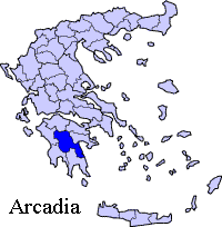
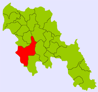
Petrovouni (Greek, Modern: Πετροβούνι meaning rock town, Katharevousa: -ον -on), older forms: -o and -on is a Greek settlement in the southwest of the Arcadia prefecture Petrovouni is connected with the road linking the Vasta - Megalopoli Road and Lykaio as well as the road connecting Lykaia and Megalopoli. Petrovouni is also in the municipal district of Isari and the municipality of Megalopoli. Petrovouni had a 2001 population of 22 for the settlement. Petrovouni is located about 25 km (old: 20 km) northwest of Megalopoli, 30 km direct southeast and 65 km (old: 60 km) southeast of Andritsaina about 53 km (north of Kalamata and about 58 km (old: 53 km) west-southwest of Tripoli. The GR-76 is to the east as well as the GR-7, the older and the new route is to the southeast as well as the superhighway.
The area features rocky soul in which the name of the village originates.
Nearest places
* Apiditsa, east
* Chrousa, southeast
* Chranoi, south
* Isari, southwest
* Lykosoura, northwest
Geography
Petrovouni is situated in a mountainous slope overlooking the valley and the Alfieos valley, The river is 8 km east. The area are made up of forests and grasslands as well as to the east. The mountains cover the area and are made up of rocks with grasslands and bushes along with a couple of forests and grasses and bushes around the areas. Farmlands are within the village area. A slopey part lies to the southwest where it has a curvy road at the Vasta-Megalopoli Road. It offers panoramic views of the Lykaio mountains to the northwest, the east, the southeast and the south. Its main production are olives, citrus, fruits, vegetables and other crops, several common crops are rarely common.
Chrousa has several rural roads and approximately 10 km of hydro lines.
Its residential houses and buildings are within the main road and it is about 200 to 300 m long wide at the centre. Much of the houses were stone built until the 1960s. Electricity arrived in the same year. Vehicles arrived in the 1970s, the pavement of the main road and television arrived in the 1980s and computer and internet are rarely known in the beginning of the 21st century and up to date technology are not seen.
Population
Year Population
1981 92
1991 28
2001 22
History
The village used to have a large population before the beginning of the 20th century. After World War II and the Greek Civil War, the population began to decline as residents moved to larger towns and cities and outside of Greece. One exception was that the population slightly grew between 1991 and 2001.
Other
Petrovouni has a church, and a square (plateia), its nearest school and lyceum (middle school) and gymnasium (secondary school) are now in Megalopoli since 2005 and Isari.
Links
* History and Information about Petrovouni
| Ancient Greece
Science, Technology , Medicine , Warfare, , Biographies , Life , Cities/Places/Maps , Arts , Literature , Philosophy ,Olympics, Mythology , History , Images Medieval Greece / Byzantine Empire Science, Technology, Arts, , Warfare , Literature, Biographies, Icons, History Modern Greece Cities, Islands, Regions, Fauna/Flora ,Biographies , History , Warfare, Science/Technology, Literature, Music , Arts , Film/Actors , Sport , Fashion --- |
Retrieved from "http://en.wikipedia.org/"
All text is available under the terms of the GNU Free Documentation License
