

Administrative Region : Central Greece
Regional unit : Voiotia
Kallithea (Καλλιθέα) Voiotia
Kallithea is a village in the prefecture of Voiotia. It is one of the four Local Communities of the Municipal Unit of Tanagra, which until 2010 was the Kapodistrian Municipality of Tanagra. Since 2011 it belongs to the new Kallikratiko Municipality of Tanagra. The population of the village amounts to 752 inhabitants, according to the 2011 Census.
In ancient times it was called Sides, ie Rodies as they thrive in the area, while during the Turkish occupation it was called Mustafaades, probably from the name of a Turkish ruler of the area.
Interests
In Kallithea in 2012 a Dancing Cultural Association was founded with the ancient name of the village Sides, where traditional dances and songs are taught.
Economy
The economy of the village, as well as the other villages of the municipality, is mainly based on agriculture, processing and trade of agricultural products. The village is inhabited mainly by residents with the surname Skourtaniotis who come from the great fighter Athanasios Skourtaniotis general of the area in the revolution of 1821.
The oldest name of the village was Mustafaades. It was renamed Kallithea in 1953. There is no clear evidence why this village retained the name Mustafa until 1953. According to the oral tradition, a Turkish official or tycoon named Mustafa was installed in the area of the village of Pyrgos, but even that is questionable. Mustafas in Arabic means the one who stands out, the distinguished one. The name Mustafa came from 2 brothers who were janissaries with the same name mustafa. Shelter hunters of 1821. When we went they said to the Mustafaades, so the name of the village came out, and not from Mustafabei who had once encamped for a while in the area.
The village is built on the outskirts of Mount Pyrgari and is located between the villages of Neochoraki and Asopia. According to the 2011 census, its population is 752 inhabitants.
Its inhabitants are mostly farmers. The close distance from Athens on the one hand, only 70 km, and on the other hand the fertile and efficient plain next to Asopos that stretches in front of it, specialized the village in one of the largest feeders of agricultural products of the Central Vegetable Market of Athens. After 1960, crops are intensive in both cereals (durum wheat, barley, oats, etc.) and vegetables (tomatoes, okra, beans, peppers). Potatoes and onions are also grown, as well as industrial tomatoes.
Irrigation was initially done by rising wells. After 1960, 60-70 meters of drilling began to take place, which over the years became deeper and deeper to find water: today the boreholes are about 370 meters deep, with the result that the water has a lot of salts.
Churches
The patron saint of the village is Agios Georgios the Trophy Bearer. The Holy Temple began to be built in 1923 by the inhabitants of the village, is made of local yellow stone and is the most important and beautiful part of the village. The memory of St. George is celebrated every year on April 22 and 23 unless moved due to The cemetery church of the village is dedicated to Agia Paraskevi and is the oldest church, celebrating on July 26. Other chapels are: St. Anna (July 25), St. John the Baptist (April 29), the Holy Brigadiers (November 8), the Holy Trinity (mobile holiday), Panagia Mesosporitissa (November 21), St. Marina the Great Martyr (July 16).
According to the Kapodistrian law of 1997, the village belonged to the Municipality of Tanagra together with the villages of Arma, Asopia, Tanagra, where in 2010 it joined the new enlarged municipality of Tanagra together with the Municipality of Schimatari, Oinofyta, Dervenochorion and Dilesiou.
Signs from archaeological research confirm that the area has been inhabited since ancient times, but this does not mean exactly the same place. Within a radius of two kilometers around the current village there are samples of settlements, such as in the area of Lykoursi (southwest), in the area of Kourtani south and in the area of Metochi (west). Also at the top of Mount Soros west of today's village, there are specimens of Cyclops walls of the Mycenaean period. A Dutch archaeologist [pending reference] who recently conducted research in the area of the Holy Trinity said that the current temple is built on an ancient and rare temple of the goddess Hera. It is said that the ancient name of the village is Sides, which means Pomegranates. Indeed, pomegranates thrive in the area, although today they are only used for home consumption.
Sources
Tseva G., The History of Thebes and Boeotia, Cultural Center of the Municipality of Thebes, Thebes 2006
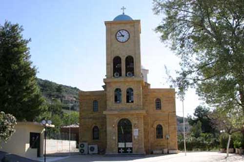
Agios Georgios Church
| Municipal unit Tanagra |
|---|
| Community Arma |
| Arma (Άρμα, το) |
| Community Asopia |
| Asopia (Ασωπία, η) |
| Community Kallithea |
| Kallithea (Καλλιθέα, η) |
| Community Tanagra |
| Panagia (Παναγία, η) |
| Tanagra (Τανάγρα, η) |
Greece :
A - B - C - D - E - F - G - H - I - J - K - L - M -
N - O - P - Q - R - S - T - U - V - W - X - Y - Z
Retrieved from "http://en.wikipedia.org/"
All text is available under the terms of the GNU Free Documentation License
| Ancient Greece
Science, Technology , Medicine , Warfare, , Biographies , Life , Cities/Places/Maps , Arts , Literature , Philosophy ,Olympics, Mythology , History , Images Medieval Greece / Byzantine Empire Science, Technology, Arts, , Warfare , Literature, Biographies, Icons, History Modern Greece Cities, Islands, Regions, Fauna/Flora ,Biographies , History , Warfare, Science/Technology, Literature, Music , Arts , Film/Actors , Sport , Fashion --- |
