
.
4, 5, 6,
7, 8, 9, 10, 11,
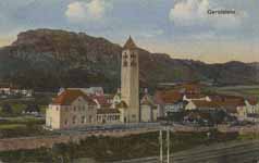
Gerolstein
Gerolstein is a town in the Vulkaneifel district in Rhineland-Palatinate, Germany. It is the seat of the like-named Verbandsgemeinde. Gerolstein is headquarters to a large mineral water firm, Gerolsteiner Brunnen. The town is also a climatic spa (Luftkurort).
Geography
Location
The town lies on the river Kyll in the Vulkaneifel, a part of the Eifel known for its volcanic history, geographical and geological features, and even ongoing activity today, including gases that sometimes well up from the earth.
Constituent communities
Gerolstein’s Stadtteile, besides the main town, also called Gerolstein, are Bewingen, Büscheich-Niedereich, Gees, Hinterhausen, Lissingen, Michelbach, Müllenborn, Oos and Roth.
History
Gerolstein
One form of the name Gerolstein first cropped up in connection with the building of the Löwenburg (Castle Gerolstein) in 1115, which was then named as the Burg Gerhardstein. Nevertheless, as early as the Stone Age there is evidence of human habitation in the Buchenloch, a nearby cave. In the Bronze Age, the Dietzenley was used by the Celts as a flight castle. From Roman times, a temple and dwellings are known, and remnants are preserved.
Town rights were granted Gerolstein in 1337. In 1691, the town was almost utterly destroyed when it was liberated from French occupation by troops from the Duchy of Jülich. After reconstruction, there was a devastating fire that burnt the town down in 1708; another, likewise disastrous, came in 1784. In the 1801 Treaty of Lunéville, Gerolstein, along with all areas on the Rhine’s left bank, passed to France, and were only returned to German control in 1815. Count Sternberg-Manderscheid acquired in the 1803 Reichsdeputationshauptschluss as the landholder, among other things, the holdings formerly belonging to the monasteries at Weissenau and Schussenried in Upper Swabia to offset his loss of Blankenheim, Jünkerath, Gerolstein and Dollendorf. It is known that water from the spring that had once been used by the Celts and the Romans was being bottled and sold beginning in 1724. This still forms the basis for today’s mineral water industry in Gerolstein. Late in the Second World War, in 1944 and 1945, Gerolstein’s status as a railway junction town brought Allied air raids down on the town, and 80% of it was destroyed. Town rights were granted Gerolstein once again in 1953.
Bewingen
Bewingen is Gerolstein’s northernmost outlying centre, or Stadtteil, lying three kilometres away from the town centre. Here the Kyll flows in a great bow round the mighty dolomite and basalt massif that juts from the west eastwards. The valley narrows and there is only enough room here for the railway line, a field road and the river itself. The road finds its way to Gerolstein over the Bewinger Höhe (heights), thus somewhat shortening the way to the nearby middle centre. The local lie of the land was brought about by the local volcanic activity, which created two volcanic peaks, the Kasselburgmassiv with the Burlich and the Hahn (“Cock”) on the Kyll’s west bank, and the Rockeskyller Kopf on the east, whose volcanic minerals and deposits of lava, ash and cinders from the Quaternary narrow the river valley.
Kasselburg ruins at Pelm (near Gerolstein)
The placename ending —ingen points to early Frankish settlement. Bewingen had its first documentary mention in 1218 as a holding of the monastery and church of Niederehe. From that mention, it is known that the Brothers Theoderich, Alexander and Albero from Castle Kerpen established an endowment for the Premonstratensian nuns here in the years between 1162 and 1175. The next documentary mention came in 1282, when “Gerhard VI of Blankenheim” acquired lands, among others Steffeln, Niederbettingen and Bewingen. In the Middle Ages, the lords at Kasselburg (castle) and those at Castle Gerhardstein (Gerolstein) held lands and tithing rights in the village.[2] In the time of French rule, beginning in 1794, Bewingen was assigned to the Mairie (“Mayoralty”) of Rockeskyll, and the village remained within the Bürgermeisterei (also “Mayoralty”) of Rockeskyll on into Prussian times. The formerly self-administering municipality of Bewingen was amalgamated with the town of Gerolstein in 1969.
One of the verifiably oldest buildings is the small chapel consecrated to Saint Brice, which underwent repairs in 1744 and 1745.[3] Its Late Gothic quire suggests that there was an earlier church here, built perhaps about 1500.
Büscheich-Niedereich
Büscheich-Niedereich lies roughly 5 km away from the town centre. In 1352, it had its first documentary mention, although Niedereich’s first documentary mention did not come until 1398.
In 1501, the hereditary estate of Eich (Niedereich) belonged to the County of Gerolstein. On 13 May 1661, the hereditary estate was divided into Niedereich and Obereich.
When the French occupied the Eifel in the 18th century, the Counts lost all their holdings. After the French were driven out, the Eifel became Prussian. In 1815, the Prussian government changed Obereich’s name to Büscheich.
Politics
Gerolstein is the seat of the Verbandsgemeinde of Gerolstein, to which belong the municipalities of Berlingen, Birresborn, Densborn, Duppach, Hohenfels-Essingen, Kalenborn-Scheuern, Kopp, Mürlenbach, Neroth, Pelm, Rockeskyll and Salm.
Town council
The council is made up of 24 council members, who were elected by proportional representation at the municipal election held on 7 June 2009, and the mayor as chairman.
The municipal election held on 7 June 2009 yielded the following results[4]:
CDU SPD BUV GRÜNE FDP Total
2004 13 5 5 1 – 24 seats
2009 11 6 4 2 1 24 seats
Mayor
Gerolstein’s honorary mayor is chosen every five years in a direct vote. The current office holder is Karl-Heinz Schwartz (CDU).
Amalgamations
On 7 June 1969, the municipalities of Bewingen, Hinterhausen and Lissingen were amalgamated with Gerolstein. Büscheich, Gees, Michelbach, Müllenborn, Oos and Roth were amalgamated on 1 December 1972.
Coat of arms
The town’s arms might be described thus: Or a lion rampant sable armed and langued gules surmounted at the shoulder by a label of five points of the last.
The town’s arms are actually those formerly borne by the Counts of Gerolstein-Blankenheim, the former landholders. The composition is known from 1567 when it appeared in a seal used by the town’s Schöffen (roughly “lay jurists”). The town has borne these arms since about 1890, but no official approval to do so is known to have been issued.[5]
Town partnerships
Gerolstein fosters partnerships with the following places:
France Digoin, Saône-et-Loire, France since 1987
Netherlands Gilze en Rijen, North Brabant, Netherlands
Culture and sightseeing
Gerolstein with Munterley, Auberg and Rothe Hecke
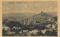
Beyond the sightseeing attractions listed hereafter, there are other things to be seen in and around Gerolstein, such as the dried-up maar called Papenkaule, the Buchenloch, a 36-metre-long karst cave that served as a dwelling for Stone Age people, the Mühlsteinhöhlen (“millstone caves”) or Eishöhlen (“ice caves”) near Roth, a natural history museum and a district local history museum. A walk leads to the Gerolsteiner Dolomiten, a Devonian limestone reef formed by extinct Rugosa, Tabulata and Stromatoporoids with the Hustley, the Munterley and the Auberg. They dominate the town’s appearance, looming 100 m above the valley.
Buildings
Main town
Gerolstein, monumental zone, Gerolstein castle ruins
Gerolstein castle (Löwenburg) ruins, Bergstraße, monumental zone, castle founded in the earlier half of the 14th century by Gerhard VI of Blankenburg and destroyed in 1691, defensive wall in the outer bailey preserved, remnants of living quarters preserved in the main stronghold.
Evangelical Church of the Redeemer, Sarresdorfer Straße 17, cruciform central-plan building after Italo-Byzantine models, 1911–1913, complex with treed lot and fence dating from the time of building, rectory (Sarresdorfer Straße 15 a), former parish house (?; Sarresdorfer Straße 19 a), Classicist hipped-roof building.
Saint Anne’s Catholic Parish Church (Pfarrkirche St. Anna), aisleless church from 1811, expanded in 1884 and 1948, complex with rectory, possibly from about 1800.
Town fortifications, Am Stadtturm 1, Hauptstraße 41, 75, Mühlenstraße 19 (monumental zone), section of 14th-century town wall between a jutting half-round tower (integrated into Hauptstraße 75) and a great tower (Am Stadtturm 1), a further section of town wall with gate remnants (Mühlenstraße 19) and a pillar-shaped town wall remnant (Hauptstraße 41).
Bahnhofstraße 4 – Gothic Revival railway station, 1870, expanded after the Second World War.
Bahnhofstraße 17 – stately house, apparently from 1902.
Brunnenstraße 11, 13 – factory building, façade with colourful wall tiles and glass bricks, date unknown.
Graf-Karl-Ferdinand-Straße – so-called Burgkreuz (“Castle Cross”), a niche cross possibly from the 16th or 17th century.
Near Hauptstraße 10 – Heiligenhäuschen (a small, shrinelike structure consecrated to a saint or saints), Baroque, sandstone, from 1771 and 1784.
Near Hauptstraße 42 – a Descent from the Cross group, sandstone, apparently from 1838.
Hauptstraße 59, 61 – houses, one at 59 from 1903 but essentially older, Late Gothic Revival entrance, one at 61 from 1747 and 1822.
Hauptstraße 76 – house used as dwelling and inn with half-hipped gables, date unclear.
Heiligensteinstraße 5/7 – pair of semidetached houses with half-hipped gables, lava stone façade, about 1900.
Kyllweg – warriors’ memorial, 1914-1918.
Lindenstraße (no number) – former Oos wireworks, founded in 1882, no. 43a director’s villa (?), plaster building with corner tower.
Lindenstraße 6 – former railway works building, representative quarrystone building, apparently from 1890.
Mühlenstraße 19 – timber-frame house, partly solid.
Sarresdorfer Straße/Am Auberg – Jewish graveyard (monumental zone), on the area of the general cemetery, opened in 1892, about 15 gravestones, oldest from 1896.
Sarresdorfer Straße – former Roman villa of Sarabodis, remnants of the Roman estate at Sarresdorf, donated in 762 by Pepin to Prüm Abbey, since 1913 “Museum Sarabodis”.
Sarresdorfer Straße 15 a – Evangelical rectory
Sarresdorfer Straße 19 a – Evangelical parish house (?)
Sarresdorfer Straße 26 – former parish house, now district local history museum, Renaissance building from about 1550, Baroque red-sandstone shaft cross from latter half of 18th century.
Unter den Dolomiten – forester’s office with half-hipped gables, Reform architecture, side building timber-frame, partly solid, from about 1920.
At the Büschkapelle – warriors’ memorial 1848, 1864, 1866, 1870–1871, pedestal, obelisk and cross.
Büschkapelle, southeast of town in the woods, Gothic Revival chapel, quarrystone, 1904.
So-called Fruhnertskreuz, north of town on the edge of the town forest, sandstone shaft cross from 1796 (1726?).
Bewingen
Saint Brice’s Catholic Church (branch church; Filialkirche St. Brictius), Bewinger Straße, Late Gothic quire, Gothic Revival nave, 17th century.
Bewinger Straße 40 – estate along street from 1914, old cobbles in yard.
Büscheich
Saint John the Baptist’s Catholic Church (branch church; Filialkirche St. Johannes Baptista), Büscheicher Straße, aisleless church, apparently from 1670, west portal 19th century, possibly expanded after 1945.
Niedereicher Straße 6 – former school, one-floor plaster building, apparently from 1906.
Zur Dietzenley 2 – house from 1787.
Zur Dietzenley 3 – Quereinhaus (a combination residential and commercial house divided for these two purposes down the middle, perpendicularly to the street) from 1876.
Niedereich 18 – house with mighty chimney, from 1804.
So-called Davitzkreuz, northwest of the village in the woods, Baroque shaft cross from 1764.
Gees
Saint Nicholas’s Catholic Church (branch church; Filialkirche St. Nikolaus), quarrystone aisleless church, 1904, former quire tower, to the south a sandstone Baroque shaft cross from 1819.
At Am Bungert 1 – one-floor bakehouse from 1807.
Geeser Straße 29 – corner estate from 1860.
Geeser Straße 31 – Late Baroque plaster building, about 1800.
Geeser Straße 40 – triaxial plaster building from 1809 (?).
Geeser Straße 48 – house of a former estate complex, date unknown.
Geeser Straße 63 – Quereinhaus, late 18th century, yard partly cobbled.
So-called Jardin-Kreuz, northwest of the village on a field path, Baroque shaft cross from 1768.
Hinterhausen
Saint Lambert’s Catholic Church (branch church; Filialkirche St. Lambert), Hinterhausener Straße, biaxial aisleless church, 1867.
Village centre, Hinterhausener Straße (monumental zone), old village centre with branch chapel and estate complexes on ring-shaped street, 19th century, distinctive village appearance, distinctive street layout.
Hinterhausener Straße 14 – estate complex, house from 1864, commercial building.
Lissingen
Lissingen castle
Burg Lissingen (castle), Burgstraße/Klosterstraße (monumental zone), stately group of buildings on the Kyll consisting of upper and lower castle, the mediaeval building steadily expanded in the 14th to 17th centuries, commercial building on site of old ringwall, between upper and lower castle a four-floor tower from the 14th century, outer gate at the southwest corner of the upper castle from 1624, in the lower castle a dwelling building, essentially Gothic, park with garden house from 1793, complex includes Klosterstraße 1: estate along street, latter half of 19th century; Klosterstraße 3: possibly a former bursary, Baroque hipped mansard roof.
Saint Margaret’s Catholic Church (branch church; Filialkirche St. Margaretha), five-axis aisleless church, 1932.
Michelbach
Saint Stephen’s Catholic Church (branch church; Filialkirche St. Stephan), triaxial aisleless church, 1781.
Near Birresborner Straße 22 – wayside cross, niche cross from earlier half of 17th century.
Michelbacher Straße 2 – triaxial house, apparently a former curate’s house, 18th century.
Michelbacher Straße 17 – house, 1872, oven porch.
Müllenborn
Saint Anthony’s Catholic Church (branch church; Filialkirche St. Antonius), Müllenborner Straße 39, biaxial aisleless church, 1682.
Amselweg 9 – former railway station on the Gerolstein-Pronsfeld line, quarrystone, apparently from 1883.
Fricksbachstraße/corner of Auf der Held – wayside cross, beam cross from 1794.
Müllenborner Straße 32 – representative building with half-hipped gables from 1820.
Müllenborner Straße 34 – six-axis Classicist house, latter half of 19th century.
Müllenborner Straße 36 – stately Baroque building with mansard roof, apparently from 1804.
Müllenborner Straße 38 – Baroque half house from 1786.
Near Müllenborner Straße 73 – wayside cross, sandstone shaft cross from 1778.
Müllenborner Straße 89/91 – small estate complex, Baroque house from 1777, stable-barn with tower and crow-stepped gable, apparently 1482/1550.
Müllenborner Straße 103 – estate complex house, remodelled in the 19th century.
Müllenborner Straße 107 – estate complex.
Müllenborner Straße/corner of Amselweg – wayside cross, Gothic Revival from 1914.
Oos
Saint Roch’s Catholic Church (branch church; Filialkirche St. Rochus), Ooser Straße 18, two-naved Romanesque Revival building, 1906-1907, Romanesque west tower.
Wayside cross, west of the village on the road to Büdesheim, Crucifixion Bildstock from 1619.
Roth
Saint Anthony’s Catholic Church (branch church; Filialkirche St. Antonius), An der Kirche 10, Gothic Revival aisleless church, 1892, sandstone shaft cross from 1680s (last digit unclear).
An der Kirche 4 – Quereinhaus from 1774, oven porch.
An der Kirche 12 – former parish estate built of basalt, possibly latter half of 19th century, commercial building, yard.
Across the street from Rother Straße 40 – wayside cross, shaft cross, possibly earlier half of 19th century.[6]
Castle of Lissingen
Burg Lissingen
On the outskirts of the outlying centre of Lissingen stands the former moated Castle of Lissingen, not far from the Kyll. The oldest parts of the building come from 1280, although the castle had already been mentioned in documents by 1212. Unlike most castles in the Eifel, it was not destroyed. In 1559 it was divided into an upper and lower castle. The lower castle is used as an event and cultural venue.
Erlöserkirche
Gerolstein, Sarresdorfer Straße 17: Evangelical Church of the Redeemer (Erlöserkirche) with Munterley
The Evangelical Erlöserkirche (“Church of the Redeemer”) was built between 1907 and 1913 by Franz Schwechten (the same architect who designed, among other things, Berlin’s Kaiser Wilhelm Memorial Church), and was consecrated on 15 October 1913. The inside is decorated with broad, gold mosaics, round arches and a commanding cupola.
Villa Sarabodis
Villa Sarabodis is the name given the remnants of a Roman lordly seat – villa rustica. They were unearthed in the course of preparatory work for building the Church of the Redeemer in 1907. The remnants have been dated to the first century AD. The Kirchenbauverein Berlin (“Berlin Church-Building Association”), which also built the Church of the Redeemer, dug the finds up: foundations and a hypocaust can now be viewed in a protective building.
Juddekirchhof
The Juddekirchhof, as it is known in the local speech, is a Celtic-Roman worship site. It lies above Gerolstein on the Hustley, a part of the Gerolsteiner Dolomiten.
The Roman Marcus Victorius Pellentius had this temple complex built in AD 124. The wall remnants measure roughly 63 by 46 metres. Within this ringwall, foundations of many buildings, among which are two temples, are preserved. One temple was dedicated to Hercules while the other was dedicated to the Celtic goddess Caiva. In 1927 and 1928, remnants of the temple complex were excavated.
Economy and infrastructure
Transport
Gerolstein, Bahnhofstraße 4: Gothic Revival railway station
Gerolstein railway station lies on the Eifelbahn (Cologne–Euskirchen–Gerolstein–Trier), which is served by the following local passenger services:
the Eifel-Mosel-Express (Cologne–Euskirchen–Gerolstein–Trier);
the Eifel-Express (Cologne–Euskirchen–Gerolstein with connection to Trier);
the Eifel-Bahn (Cologne–Euskirchen–Kall, and at peak times on to Gerolstein);
the Eifelbahn (Gerolstein–Trier).
In Gerolstein, the historical Eifelquerbahn (“Cross-Eifel Railway”) branches off, leading by way of Daun to Kaisersesch and on to Andernach, as does the Westeifelbahn leading by way of Prüm to Sankt Vith (until 1918 in the German Empire, nowadays in Belgium).
For all local public transport, three tariff systems apply: the Verkehrsverbund Region Trier (VRT), the Verkehrsverbund Rhein-Sieg, and for journeys crossing tariff zones, the NRW-Tarif.
Established businesses
Gerolsteiner Brunnen has its headquarters in Gerolstein.
Bundeswehr
Eifelkaserne (Führungsunterstützungsbataillon 281) – barracks
Famous people
Sons and daughters of the town
Maria Reese (1889–1958), writer, journalist and politician
Rolf Huisgen (1920– ), chemist
Alois Mertes (1921–1985), politician and state minister in the foreign office
Matthias Krings (1943– ), moderator
Michael Fisch (1964– ), writer
Johannes Fröhlinger (1985– ), competition cyclist
Christian Vietoris (1989– ), auto racer
Rudi Gores (1957– ), footballer and trainer
Sundry
Gerolstein is also the name of a fictional country in Central Europe, a subject of Jacques Offenbach's opéra bouffe la Grande-Duchesse de Gérolstein (The Grand Duchess of Gerolstein).
Further reading
Peter Daners: Die evangelische Erlöserkirche in Gerolstein (Rheinische Kunststätten, Heft 445). Köln 2000, 24 S., ISBN 3-88094-854-2
Hedwig Judeich: Der Ammerländer Friedrich Schwarting (1883–1918) Kirchenmaler im Kaiserreich. Tagebuchaufzeichnungen mit Dokumenten und Bildzeugnissen. Hrsg. v. Hedwig Judeich. Oldenburg (Verlag Isensee) 1989, 144 S. ISBN 3-920557-84-0
References
^ "Bevölkerung der Gemeinden am 31.12.2010" (in German). Statistisches Landesamt Rheinland-Pfalz. 2011.
^ Dettmann, Rolf, Weber, Matthias: Das Kylltal in der Eifel, Köln 1986, S. 76
^ Dohm/Winter: Gerolstein 1986
^ Kommunalwahl Rheinland-Pfalz 2009, Stadtrat
^ Description and explanation of Gerolstein’s arms
^ Directory of Cultural Monum From Wikipedia, All text is available under the terms of the GNU Free Documentation Licenseents in Vulkaneifel district
