
.
Brandenburg
Brandenburg an der Havel is a town in the state of Brandenburg (which is why it is also called Brandenburg City in English), Germany, with a population of 71,778 (as of 2010). It is located on the banks of the River Havel. The town of Brandenburg, which is almost as widely known as the state of Brandenburg, provided the name for the medieval Bishopric of Brandenburg, the Margraviate of Brandenburg, and the current state of Brandenburg. Today it is a small town compared to nearby Berlin, but it was the original nucleus of the former realms of Brandenburg and Prussia.
History
The castle of Brandenburg, which had been a fortress of the Slavic tribe Stodoranie, was conquered in 929 by King Henry the Fowler. The town remained German only until 983, when a Slavic rebellion was successful. During the next 170 years the area was ruled by Slavic princes of the Hevelli tribe. The last of them, Pribislav, died in 1150. Afterwards Albert I settled here and became the first margrave of Brandenburg. The town was restricted to the western bank of the Havel until 1196, when it was extended to the eastern side. The parts on either side of the river were regarded as three different towns (Old Town, New Town and Brandenburg cathedral district) for centuries.
In 1314–1315 the Old and New Towns joined the Hanseatic League. In the Thirty Years' War (1618–1648) the towns suffered plundering and destruction which led to a loss of power; Potsdam became the new capital, and the court left the town of Brandenburg. In 1715 Old Town and New Town were merged to form a single town. In 1928 the Brandenburg cathedral district was added.
In the late 19th century Brandenburg an der Havel became a very important industrial center in the German Empire. Steel industries settled there, and several world famous bicycle brands such as Brennabor, Corona and Excelsior were manufactured in the city. A world famous toy industry was also established. With a giant industrial complex, the Deutsche Reichsbahn (German Imperial Railways) was located in Brandenburg-Kirchmöser during the time between the two world wars and the time of the former GDR. The city's excellent transport infrastructure was a big advantage.
Nazi era
A concentration camp, one of the first in Germany, was located on Neuendorfer Straße in Brandenburg Old Town. After closing this inner city concentration camp, the Nazis used the Brandenburg-Görden Prison, located in Görden, a suburb of Brandenburg. Later the old gaol became the Brandenburg Euthanasia Centre where the Nazis killed people with mental diseases, including children. They called this operation "Action T4" because of the Berlin address, Tiergartenstraße 4, the headquarters of this planned and well-organized killing "euthanasia" organisation. Brandenburg an der Havel was one of the very first locations in the Third Reich where the Nazis experimented with killing their victims by gas. Here, they prepared the mass killings in Auschwitz and other extermination camps. After complaints by local inhabitants about the smoke, the mobile furnaces used to burn the corpses ceased operation. Shortly after this, the Nazis closed the old prison.
In 1934, the Arado Aircraft Company (Arado Flugzeugwerke), which originated in Warnemünde, began building a satellite factory in Brandenburg that began producing planes in 1935. The factory was expanded over the next five years, and during World War II produced trainers and other aircraft for the Luftwaffe. The existence of this factory was one of the reasons Brandenburg was heavily bombed in later stages of the war; by 1945 the city was 70 percent destroyed.
Friedrich Fromm, a German officer involved in the July 20 plot to assassinate Hitler, was executed here in March 1945 for his part in the plot, even though Fromm betrayed those conspirators he knew and ordered their execution.
After the unification the city's population declined from over 100,000 in 1989 to roughly 75,000 in 2005 through emigration. The migration was mainly by young people. As a result, the future of the city is uncertain.
Population statistics
year population
1600 10 000
1648 3 000
1715 11 000
1818 12 800
1830 13 538
December 3, 1861 21 600
December 3, 1864 26 000
December 3, 1867 25 500
December 1, 1871 25 800
December 1, 1875 27 371
December 1, 1880 29 066
December 1, 1885 33 129
December 1, 1890 37 817
year population
December 2, 1895 42 690
December 1, 1900 49 250
December 1, 1905 51 200
December 1, 1910 53 595
December 1, 1916 48 039
December 5, 1917 49 565
October 8, 1919 52 972
June 16, 1925 59 297
June 16, 1933 64 190
May 17, 1939 83 825
December 1, 1945 68 927
October 29, 1946 70 632
August 31, 1950 82 215
year population
December 31, 1955 87 143
December 31, 1960 86 722
December 31, 1964 89 697
January 1, 1971 93 983
December 31, 1975 93 765
December 31, 1981 94 680
December 31, 1985 94 862
December 31, 1988 94 872
December 31, 1990 89 889
December 31, 1995 85 994
December 31, 2000 77 516
December 31, 2005 74 129
December 31, 2010 71 778
Transport
The city is located on the navigable River Havel, a European Waterway, and vessels travelling through the city have a choice of two routes. The original route used the Brandenburg City Canal, a 4-kilometre (2.5 mi) route through the city centre that descends through the Stadtschleuse Brandenburg, but this route is constrained in size and now limited to leisure craft. Commercial traffic instead uses the Silo Canal that passes through the eastern and northern fringes of the city.[2]
The city is located at the junction of Federal Highways 1 and 102 and the A2 autobahn is nearby. The Berlin and Magdeburg railway also runs through Brandenburg an der Havel.
Sights
Panoramic view over Brandenburg.
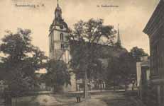
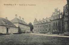
The Dominsel (Cathedral Island) is the historic heart of the town. Here stands its oldest edifice: the Dom St. Peter und Paul (Cathedral of Saints Peter and Paul). Although construction began in the Romanesque style in 1165, it was completed as a Gothic cathedral during the 14th century. While the exterior is rather austere, the cathedral surprises the visitor with its sumptuous interior, especially the painted vault of the Bunte Kapelle (Coloured Chapel) and the Wagner organ (1725), one of the most famous Baroque organs in Germany.
The Katharinenkirche (St. Catherine's Church) built in 1401 in the Neustadt is an impressive example of northern German brick Gothic architecture. The Gotthardtkirche (St. Gotthardt's Church) was built of the same material just a few years later.
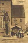
Another interesting building is the Altstädtisches Rathaus (Old Town Hall), a late Gothic brick building with stepped gables and an ornate portal. In front of it stands a 5.35m high statue of the knight Roland. Made of sandstone, the statue was erected in 1474 as a symbol of the town's independence.
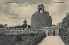
There is also a part of Brandenburg's medieval city wall, with four preserved watchtowers: Steintorturm and Mühlentorturm (in the New Town), and Rathenower Torturm and Plauer Torturm (in the Old Town).
The Brandenburg Industrial Museum is an Anchor Point of ERIH, The European Route of Industrial Heritage. Brandenburg has its own theatre (Brandenburger Theater), a professional symphony orchestra (Brandenburger Symphoniker) and a wide range of local history and archaeology museums.
Brandenburg Cathedral
St. Gotthardt's Church
Altstädtischer Markt, Old Town Hall
Roland statue in front of the Old Town Hall
Steintorturm
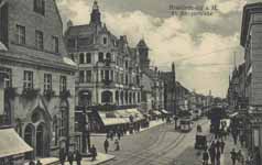
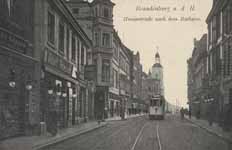
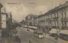
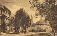
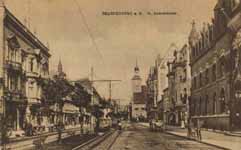
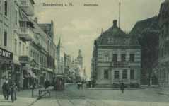
Hauptstraße and St. Catherine's Church
St. Catherine's Church
Archaeological Museum (former St. Paul's Church)
Notable residents
Gustav Noske (1868–1946), German politician, Minister of Defence between 1919 and 1920.
Twin towns
France Ivry-sur-Seine, France
Germany Kaiserslautern, Germany
Russia Magnitogorsk, Russia
See also
Brandenburg Gate in Berlin
Brandenburg Hauptbahnhof
Stahl Brandenburg
Brandenburger SC Süd 05
References
^ "Bevölkerung im Land Brandenburg am am 30. Dezember 2010 nach amtsfreien Gemeinden, Ämtern und Gemeinden. Gebietsstand: 31.12.2010" (in German). Amt für Statistik Berlin-Brandenburg. 31 December 2010.
^ Sheffield, Barry (1995). Inland Waterways of Germany. St Ives: Imray Laurie Norie & Wilson. pp. 93–100. ISBN 0 85288 283 1.
From Wikipedia, All text is available under the terms of the GNU Free Documentation License
