
.
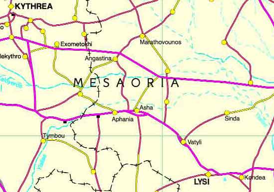
The Mesaoria is a broad, sweeping plain which makes up the center of the island of Cyprus.
Geography
The Mesaoria plain is bounded on the east and west by the Mediterranean Sea, on the south by the Troodos mountains and on the north by the Kyrenia mountains. It has an area of approximately 1000 km² (390 mi²). It rises to an altitude of 325 m (1066 ft), with an average elevation of perhaps 100 m (330 ft). There are a number of rivers and other water courses crossing this plain, but none of them have water year round.
The word "Mesaoria" (sometimes spelled "Mesarya"), means "between the mountains" in Greek. For the most part, the Mesaoria is a flat, bare plain, with few trees except for those planted as windbreaks. It is the agricultural heartland of Cyprus, but it depends completely on winter rainfall and irrigation for its water, which limits production. It is also the most settled region on the island, containing dozens of villages and many of the largest towns, including the capital, Nicosia.
Due to deforestation, much of the Mesaoria is covered with "Kafkalla", which is a local term referring to calcium carbonate that has been compacted into a hardpan. The only plants that grow well on this surface are quickly eaten by grazing animals, which has greatly exacerbated soil erosion.
The climate can be uncomfortably hot in the summer, with temperatures of 40°C being common. The rainfall on the plain is significantly lower than in the mountains, but in recent years a number of dams and irrigation systems have been constructed to capture the mountain runoff.
History
Twentry million years ago Cyprus was actually two islands, which were the predecessors of the Kyrenia and Troodos mountain ranges. Approximately one million years ago, the Mesaoria plain arose, resulting in the current island of Cyprus. At various times, changing levels of the Mediterranean sea covered and exposed the plain; it has been in its present form since the end of the Pleistocene.
The Mesaoria plain shows evidence of cultivation dating from the neolithic. In classical times the entire center of the island was covered by dense forests. Most of these were cut down in the middle of the first century BC to provide wood for the Ptolemaic navy. Additionally, much wood was harvested to provide energy for the extraction of copper. However, as recently as the late sixteenth century there were still significant stands of trees on the plain. Today, the only remaining forested areas are on the surrounding mountains, particularly the Troodos range.
Images Cyprus, Famagusta District
| Ancient Greece
Science, Technology , Medicine , Warfare, , Biographies , Life , Cities/Places/Maps , Arts , Literature , Philosophy ,Olympics, Mythology , History , Images Medieval Greece / Byzantine Empire Science, Technology, Arts, , Warfare , Literature, Biographies, Icons, History Modern Greece Cities, Islands, Regions, Fauna/Flora ,Biographies , History , Warfare, Science/Technology, Literature, Music , Arts , Film/Actors , Sport , Fashion --- |
Retrieved from "http://en.wikipedia.org/"
All text is available under the terms of the GNU Free Documentation License
