
.
Antarctica
Antarctica (Antarctica)
Introduction :: Antarctica
Background: This entry usually highlights major historic events and current issues and may include a statement about one or two key future trends. Background field listing
Speculation over the existence of a "southern land" was not confirmed until the early 1820s when British and American commercial operators and British and Russian national expeditions began exploring the Antarctic Peninsula region and other areas south of the Antarctic Circle. Not until 1840 was it established that Antarctica was indeed a continent and not merely a group of islands or an area of ocean. Several exploration "firsts" were achieved in the early 20th century, but generally the area saw little human activity. Following World War II, however, the continent experienced an upsurge in scientific research. A number of countries have set up a range of year-round and seasonal stations, camps, and refuges to support scientific research in Antarctica. Seven have made territorial claims, but most countries do not recognize these claims. In order to form a legal framework for the activities of nations on the continent, an Antarctic Treaty was negotiated that neither denies nor gives recognition to existing territorial claims; signed in 1959, it entered into force in 1961. Also relevant to Antarctic governance are the Environmental Protocol to the Antarctic Treaty and the Convention for the Conservation of Antarctic Marine Living Resources.
Geography :: Antarctica
Location: This entry identifies the country's regional location, neighboring countries, and adjacent bodies of water. Location field listing
continent mostly south of the Antarctic Circle
Geographic coordinates: This entry includes rounded latitude and longitude figures for the centroid or center point of a country expressed in degrees and minutes; it is based on the locations provided in the Geographic Names Server (GNS), maintained by the National Geospatial-Intelligence Agency on behalf of the US Board on Geographic Names. Geographic coordinates field listing
90 00 S, 0 00 E
Map references: This entry includes the name of the Factbook reference map on which a country may be found. Note that boundary representations on these maps are not necessarily authoritative. The entry on Geographic coordinates may be helpful in finding some smaller countries. Map references field listing
Antarctic Region
Area: This entry includes three subfields. Total area is the sum of all land and water areas delimited by international boundaries and/or coastlines. Land area is the aggregate of all surfaces delimited by international boundaries and/or coastlines, excluding inland water bodies (lakes, reservoirs, rivers). Water area is the sum of the surfaces of all inland water bodies, such as lakes, reservoirs, or rivers, as delimited by international boundaries and/or coastlines. Area field listing
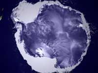
total: 14.2 million sq km
land: 14.2 million sq km (285,000 sq km ice-free, 13.915 million sq km ice-covered) (est.)
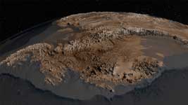
The topography of the bedrock under the Antarctic ice sheet
note: fifth-largest continent, following Asia, Africa, North America, and South America, but larger than Australia and the subcontinent of Europe
country comparison to the world: 2
Area - comparative: This entry provides an area comparison based on total area equivalents. Most entities are compared with the entire US or one of the 50 states based on area measurements (1990 revised) provided by the US Bureau of the Census. The smaller entities are compared with Washington, DC (178 sq km, 69 sq mi) or The Mall in Washington, DC (0.59 sq km, 0.23 sq mi, 146 acres). Area - comparative field listing
slightly less than 1.5 times the size of the US
Land boundaries: This entry contains the total length of all land boundaries and the individual lengths for each of the contiguous border countries. When available, official lengths published by national statistical agencies are used. Because surveying methods may differ, country border lengths reported by contiguous countries may differ. Land boundaries field listing
0
note: see entry on Disputes - international
Coastline: This entry gives the total length of the boundary between the land area (including islands) and the sea. Coastline field listing
17,968 km
Maritime claims: This entry includes the following claims, the definitions of which are excerpted from the United Nations Convention on the Law of the Sea (UNCLOS), which alone contains the full and definitive descriptions: territorial sea - the sovereignty of a coastal state extends beyond its land territory and internal waters to an adjacent belt of sea, described as the territorial sea in the UNCLOS (Part II); this sovereignty extends to the air space over the territorial sea as well as its underlying s . . . more Maritime claims field listing
Australia, Chile, and Argentina claim Exclusive Economic Zone (EEZ) rights or similar over 200 nm extensions seaward from their continental claims, but like the claims themselves, these zones are not accepted by other countries; 22 of 29 Antarctic Treaty consultative parties have made no claims to Antarctic territory (although Russia and the US have reserved the right to do so); also see the Disputes - international entry
Climate: This entry includes a brief description of typical weather regimes throughout the year; in the Word entry only, it includes four subfields that describe climate extremes:ten driest places on earth (average annual precipitation) describes the annual average precipitation measured in both millimeters and inches for selected countries with climate extremes. ten wettest places on earth (average annual precipitation) describes the annual average precipitation measured in both millimeters and i . . . more Climate field listing
the coldest, windiest, and driest continent on Earth; severe low temperatures vary with latitude, elevation, and distance from the ocean; East Antarctica is colder than West Antarctica because of its higher elevation; Antarctic Peninsula has the most moderate climate; higher temperatures occur in January along the coast and average slightly below freezing; summers characterized by continuous daylight, while winters bring continous darkness; persistent high pressure over the interior brings dry, subsiding air that results in very little cloud cover
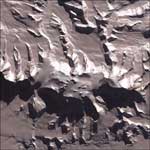
Terrain: This entry contains a brief description of the topography. Terrain field listing
about 98% thick continental ice sheet and 2% barren rock, with average elevations between 2,000 and 4,000 m; mountain ranges up to nearly 5,000 m; ice-free coastal areas include parts of southern Victoria Land, Wilkes Land, the Antarctic Peninsula area, and parts of Ross Island on McMurdo Sound; glaciers form ice shelves along about half of the coastline, and floating ice shelves constitute 11% of the area of the continent
Vinson Massif is the tallest mountain in Antarctica
Elevation: This entry includes the mean elevation and elevation extremes, lowest point and highest point. Elevation field listing
mean elevation: 2,300 m
lowest point: Denman Glacier more than -3,500 m (-11,500 ft) below sea level
highest point: Vinson Massif 4,892 m
note: the lowest known land point in Antarctica is hidden in the Denman Galcier; at its surface is the deepest ice yet discovered and the world's lowest elevation not under seawater
Natural resources: This entry lists a country's mineral, petroleum, hydropower, and other resources of commercial importance, such as rare earth elements (REEs). In general, products appear only if they make a significant contribution to the economy, or are likely to do so in the future. Natural resources field listing
iron ore, chromium, copper, gold, nickel, platinum and other minerals, and coal and hydrocarbons have been found in small noncommercial quantities; mineral exploitation except for scientific research is banned by the Environmental Protocol to the Antarctic Treaty; krill, icefish, toothfish, and crab have been taken by commercial fisheries, which are managed through the Commission for the Conservation of Antarctic Living Marine Resources (CCAMLR)
Land use: This entry contains the percentage shares of total land area for three different types of land use: agricultural land, forest, and other; agricultural land is further divided into arable land - land cultivated for crops like wheat, maize, and rice that are replanted after each harvest, permanent crops - land cultivated for crops like citrus, coffee, and rubber that are not replanted after each harvest, and includes land under flowering shrubs, fruit trees, nut trees, and vines, and permane . . . more Land use field listing
0% (2015 est.)
Natural hazards: This entry lists potential natural disasters. For countries where volcanic activity is common, a volcanism subfield highlights historically active volcanoes. Natural hazards field listing
katabatic (gravity-driven) winds blow coastward from the high interior; frequent blizzards form near the foot of the plateau; cyclonic storms form over the ocean and move clockwise along the coast; volcanism on Deception Island and isolated areas of West Antarctica; other seismic activity rare and weak; large icebergs may calve from ice shelf
Environment - current issues: This entry lists the most pressing and important environmental problems. The following terms and abbreviations are used throughout the entry: Acidification - the lowering of soil and water pH due to acid precipitation and deposition usually through precipitation; this process disrupts ecosystem nutrient flows and may kill freshwater fish and plants dependent on more neutral or alkaline conditions (see acid rain). Acid rain - characterized as containing harmful levels of sulfur dioxi . . . more Environment - current issues field listing
the discovery of a large Antarctic ozone hole in the earth's stratosphere (the ozone layer) - first announced in 1985 - spurred the signing of the Montreal Protocol in 1987, an international agreement phasing out the use of ozone-depleting chemicals; the ozone layer prevents most harmful wavelengths of ultra-violet (UV) light from passing through the earth's atmosphere; ozone depletion has been shown to harm a variety of Antarctic marine plants and animals (plankton); in 2016, a gradual trend toward "healing" of the ozone hole was reported; since the 1990s, satellites have shown accelerating ice loss driven by ocean change; although considerable uncertainty remains, scientists are increasing our understanding and ability to model potential impacts of ice loss
Geography - note: This entry includes miscellaneous geographic information of significance not included elsewhere. Geography - note field listing
the coldest, windiest, highest (on average), and driest continent; during summer, more solar radiation reaches the surface at the South Pole than is received at the Equator in an equivalent period
mostly uninhabitable, 98% of the land area is covered by the Antarctic ice sheet, the largest single mass of ice on earth covering an area of 14 million sq km (5.4 million sq mi) and containing 26.5 million cu km (6.4 million cu mi) of ice (this is almost 62% of all of the world's fresh water); if all this ice were converted to liquid water, one estimate is that it would be sufficient to raise the height of the world's oceans by 58 m (190 ft)
People and Society :: Antarctica
Population: This entry gives an estimate from the US Bureau of the Census based on statistics from population censuses, vital statistics registration systems, or sample surveys pertaining to the recent past and on assumptions about future trends. The total population presents one overall measure of the potential impact of the country on the world and within its region. Note: Starting with the 1993 Factbook, demographic estimates for some countries (mostly African) have explicitly taken into account t . . . more Population field listing
no indigenous inhabitants, but there are both permanent and summer-only staffed research stations
note: 53 countries have signed the 1959 Antarctic Treaty; 30 of those operate through their National Antarctic Program a number of seasonal-only (summer) and year-round research stations on the continent and its nearby islands south of 60 degrees south latitude (the region covered by the Antarctic Treaty); the population engaging in and supporting science or managing and protecting the Antarctic region varies from approximately 4,400 in summer to 1,100 in winter; in addition, approximately 1,000 personnel, including ship's crew and scientists doing onboard research, are present in the waters of the treaty region
as of 2017, peak summer (December-February) maximum capacity in scientific stations - 4,877 total; Argentina 601, Australia 243, Belarus 12, Belgium 40, Brazil 66, Bulgaria 22, Chile 433, China 166, Czechia 20, Ecuador 34, Finland 17, France 90, France and Italy jointly 80, Germany 104, India 113, Italy 120, Japan 130, South Korea 130, Netherlands 10, NZ 86, Norway 70, Peru 30, Poland 40, Russia 335, South Africa 80, Spain 98, Sweden 20, Ukraine 24, UK 196, US 1,399, Uruguay 68 (2017)
winter (June-August) maximum capacity in scientific station - 1,036 total; Argentina 221, Australia 52, Brazil 15, Chile 114, China 32, France 24, France and Italy jointly 13, Germany 9, India 48, Japan 40, Netherlands 10, South Korea 25, NZ 11, Norway 7, Poland 16, Russia 125, South Africa 15, Ukraine 12, UK 44, US 215, Uruguay 8 (2017)
research stations operated within the Antarctic Treaty area (south of 60 degrees south latitude) by National Antarctic Programs year-round stations - approximately 40 total; Argentina 6, Australia 3, Brazil 1, Chile 6, China 2, France 1, France and Italy jointly 1, Germany 1, India 2, Japan 1, Netherlands 1, South Korea 2, NZ 1, Norway 1, Poland 1, Russia 5, South Africa 1, Ukraine 1, UK 2, US 3, Uruguay 2 (2017)
a range of seasonal-only (summer) stations, camps, and refuges - Argentina, Australia, Belarus, Belgium, Bulgaria, Brazil, Chile, China, Czechia, Ecuador, Finland, France, Germany, India, Italy, Japan, Netherlands, South Korea, New Zealand, Norway, Peru, Poland, Russia, South Africa, Spain, Sweden, Ukraine, UK, US, and Uruguay (2017)
in addition, during the austral summer some nations have numerous occupied locations such as tent camps, summer-long temporary facilities, and mobile traverses in support of research
Education expenditures: This entry provides the public expenditure on education as a percent of GDP. Education expenditures field listing
Government :: Antarctica
Country name: This entry includes all forms of the country's name approved by the US Board on Geographic Names (Italy is used as an example): conventional long form (Italian Republic), conventional short form (Italy), local long form (Repubblica Italiana), local short form (Italia), former (Kingdom of Italy), as well as the abbreviation. Also see the Terminology note. Country name field listing
conventional long form: none
conventional short form: Antarctica
etymology: name derived from two Greek words meaning "opposite to the Arctic" or "opposite to the north"
Government type: This entry gives the basic form of government. Definitions of the major governmental terms are as follows. (Note that for some countries more than one definition applies.): Absolute monarchy - a form of government where the monarch rules unhindered, i.e., without any laws, constitution, or legally organized opposition. Anarchy - a condition of lawlessness or political disorder brought about by the absence of governmental authority. Authoritarian - a form of government in whic . . . more Government type field listing
Antarctic Treaty Summary - the Antarctic region is governed by a system known as the Antarctic Treaty system; the system includes: 1. the Antarctic Treaty, signed on 1 December 1959 and entered into force on 23 June 1961, which establishes the legal framework for the management of Antarctica, 2. Measures, Decisions, and Resolutions adopted at Antarctic Treaty Consultative Meetings, 3. The Convention for the Conservation of Antarctic Seals (1972), 4. The Convention for the Conservation of Antarctic Marine Living Resources (1980), and 5. The Protocol on Environmental Protection to the Antarctic Treaty (1991); the Antarctic Treaty Consultative Meetings operate by consensus (not by vote) of all consultative parties at annual Treaty meetings; by January 2016, there were 53 treaty member nations: 29 consultative and 24 non-consultative; consultative (decision-making) members include the seven nations that claim portions of Antarctica as national territory (some claims overlap) and 22 non-claimant nations; the US and Russia have reserved the right to make claims; the US does not recognize the claims of others; Antarctica is administered through meetings of the consultative member nations; measures adopted at these meetings are carried out by these member nations (with respect to their own nationals and operations) in accordance with their own national laws; the years in parentheses indicate when a consultative member-nation acceded to the Treaty and when it was accepted as a consultative member, while no date indicates the country was an original 1959 treaty signatory; claimant nations are - Argentina, Australia, Chile, France, NZ, Norway, and the UK; nonclaimant consultative nations are - Belgium, Brazil (1975/1983), Bulgaria (1978/1998), China (1983/1985), Czech Republic (1962/2014), Ecuador (1987/1990), Finland (1984/1989), Germany (1979/1981), India (1983/1983), Italy (1981/1987), Japan, South Korea (1986/1989), Netherlands (1967/1990), Peru (1981/1989), Poland (1961/1977), Russia, South Africa, Spain (1982/1988), Sweden (1984/1988), Ukraine (1992/2004), Uruguay (1980/1985), and the US; non-consultative members, with year of accession in parentheses, are - Austria (1987), Belarus (2006), Canada (1988), Colombia (1989), Cuba (1984), Denmark (1965), Estonia (2001), Greece (1987), Guatemala (1991), Hungary (1984), Iceland (2015), Kazakhstan (2015), North Korea (1987), Malaysia (2011), Monaco (2008), Mongolia (2015), Pakistan (2012), Papua New Guinea (1981), Portugal (2010), Romania (1971), Slovakia (1962/1993), Switzerland (1990), Turkey (1996), and Venezuela (1999); note - Czechoslovakia acceded to the Treaty in 1962 and separated into the Czech Republic and Slovakia in 1993; Article 1 - area to be used for peaceful purposes only; military activity, such as weapons testing, is prohibited, but military personnel and equipment may be used for scientific research or any other peaceful purpose; Article 2 - freedom of scientific investigation and cooperation shall continue; Article 3 - free exchange of information and personnel, cooperation with the UN and other international agencies; Article 4 - does not recognize, dispute, or establish territorial claims and no new claims shall be asserted while the treaty is in force; Article 5 - prohibits nuclear explosions or disposal of radioactive wastes;Article 6 - includes under the treaty all land and ice shelves south of 60 degrees 00 minutes south and reserves high seas rights; Article 7 - treaty-state observers have free access, including aerial observation, to any area and may inspect all stations, installations, and equipment; advance notice of all expeditions and of the introduction of military personnel must be given; Article 8 - allows for jurisdiction over observers and scientists by their own states; Article 9 - frequent consultative meetings take place among member nations; Article 10 - treaty states will discourage activities by any country in Antarctica that are contrary to the treaty; Article 11 - disputes to be settled peacefully by the parties concerned or, ultimately, by the ICJ; Articles 12, 13, 14 - deal with upholding, interpreting, and amending the treaty among involved nations; other agreements - some 200 measures adopted at treaty consultative meetings and approved by governments; the Protocol on Environmental Protection to the Antarctic Treaty was signed 4 October 1991 and entered into force 14 January 1998; this agreement provides for the protection of the Antarctic environment and includes five annexes that have entered into force: 1) environmental impact assessment, 2) conservation of Antarctic fauna and flora, 3) waste disposal and waste management, 4) prevention of marine pollution, 5) area protection and management; a sixth annex addressing liability arising from environmental emergencies has yet to enter into force; the Protocol prohibits all activities relating to mineral resources except scientific research; a permanent Antarctic Treaty Secretariat was established in 2004 in Buenos Aires, Argentina
Legal system: This entry provides the description of a country's legal system. A statement on judicial review of legislative acts is also included for a number of countries. The legal systems of nearly all countries are generally modeled upon elements of five main types: civil law (including French law, the Napoleonic Code, Roman law, Roman-Dutch law, and Spanish law); common law (including United State law); customary law; mixed or pluralistic law; and religious law (including Islamic law). An addition . . . more Legal system field listing
Antarctica is administered through annual meetings - known as Antarctic Treaty Consultative Meetings - which include consultative member nations, non-consultative member nations, observer organizations, and expert organizations; decisions from these meetings are carried out by these member nations (with respect to their own nationals and operations) in accordance with their own national laws; more generally, the Antarctic Treaty area, that is to all areas between 60 and 90 degrees south latitude, is subject to a number of relevant legal instruments and procedures adopted by the states party to the Antarctic Treaty; note - US law, including certain criminal offenses by or against US nationals, such as murder, may apply extraterritoriality; some US laws directly apply to Antarctica; for example, the Antarctic Conservation Act, 16 U.S.C. section 2401 et seq., provides civil and criminal penalties for the following activities unless authorized by regulation or statute: the taking of native mammals or birds; the introduction of nonindigenous plants and animals; entry into specially protected areas; the discharge or disposal of pollutants; and the importation into the US of certain items from Antarctica; violation of the Antarctic Conservation Act carries penalties of up to $10,000 in fines and one year in prison; the National Science Foundation and Department of Justice share enforcement responsibilities; Public Law 95-541, the US Antarctic Conservation Act of 1978, as amended in 1996, requires expeditions from the US to Antarctica to notify, in advance, the Office of Oceans and Polar Affairs, Room 2665, Department of State, Washington, DC 20520, which reports such plans to other nations as required by the Antarctic Treaty; for more information, contact antarctica@state.gov
Economy :: Antarctica
Economy - overview: This entry briefly describes the type of economy, including the degree of market orientation, the level of economic development, the most important natural resources, and the unique areas of specialization. It also characterizes major economic events and policy changes in the most recent 12 months and may include a statement about one or two key future macroeconomic trends. Economy - overview field listing
Scientific undertakings rather than commercial pursuits are the predominant human activity in Antarctica. Offshore fishing and tourism, both based abroad, account for Antarctica's limited economic activity.
Antarctic Fisheries, within the area covered by the Convention on Conservation of Antarctic Marine Living Resources currently target Patagonian toothfish, Antarctic toothfish, mackerel icefish and Antarctic krill. The Commission for the Conservation of Antarctic Marine Living Resources (CCAMLR) manages these fisheries using the ecosystem-based and precautionary approach. The Commission’s objective is conservation of Antarctic marine living resources and it regulates the fisheries based on the level of information available, and maintaining existing ecological relationships. While Illegal, Unreported and Unregulated (IUU) fishing has declined in the Convention area since 1990, it remains a concern
A total of 51,707 tourists visited the Antarctic Treaty area in the 2017-2018 Antarctic summer, 17 percent greater than the 43,915 visitors in 2016-2017. These estimates were provided to the Antarctic Treaty by the International Association of Antarctica Tour Operators and do not include passengers on overflights. Nearly all of the tourists were passengers on commercial ships and several yachts that make trips during the summer.
Energy :: Antarctica
Crude oil - production: This entry is the total amount of crude oil produced, in barrels per day (bbl/day). Crude oil - production field listing
0 bbl/day (2018 est.)
country comparison to the world: 104
Communications :: Antarctica
Telecommunication systems: This entry includes a brief general assessment of the telecommunications system with details on the domestic and international components. The following terms and abbreviations are used throughout the entry: Arabsat - Arab Satellite Communications Organization (Riyadh, Saudi Arabia). Autodin - Automatic Digital Network (US Department of Defense). CB - citizen's band mobile radio communications. Cellular telephone system - the telephones in this system are radio transceivers, with each inst . . . more Telecommunication systems field listing
general assessment: local systems at some research stations (2019)
domestic: commercial cellular networks operating in a small number of locations (2019)
international: country code - none allocated; via satellite (including mobile Inmarsat and Iridium systems) to and from all research stations, ships, aircraft, and most field parties
Internet country code: This entry includes the two-letter codes maintained by the International Organization for Standardization (ISO) in the ISO 3166 Alpha-2 list and used by the Internet Assigned Numbers Authority (IANA) to establish country-coded top-level domains (ccTLDs). Internet country code field listing
.aq
Internet users: This entry gives the total number of individuals within a country who can access the Internet at home, via any device type (computer or mobile) and connection. The percent of population with Internet access (i.e., the penetration rate) helps gauge how widespread Internet use is within a country. Statistics vary from country to country and may include users who access the Internet at least several times a week to those who access it only once within a period of several months. Internet users field listing
total: 4,400
percent of population: 100% (July 2016 est.)
country comparison to the world: 216
Military and Security :: Antarctica
Military - note: This entry includes miscellaneous military information of significance not included elsewhere. Military - note field listing
the Antarctic Treaty prohibits any measures of a military nature, such as the establishment of military bases and fortifications, the carrying out of military maneuvers, or the testing of any type of weapon; it permits the use of military personnel or equipment for scientific research or for any other peaceful purposes
Transportation :: Antarctica
Airports: This entry gives the total number of airports or airfields recognizable from the air. The runway(s) may be paved (concrete or asphalt surfaces) or unpaved (grass, earth, sand, or gravel surfaces) and may include closed or abandoned installations. Airports or airfields that are no longer recognizable (overgrown, no facilities, etc.) are not included. Note that not all airports have accommodations for refueling, maintenance, or air traffic control. Airports field listing
23 (2013)
country comparison to the world: 133
Airports - with unpaved runways: This entry gives the total number of airports with unpaved runways (grass, dirt, sand, or gravel surfaces) by length. For airports with more than one runway, only the longest runway is included according to the following five groups - (1) over 3,047 m (over 10,000 ft), (2) 2,438 to 3,047 m (8,000 to 10,000 ft), (3) 1,524 to 2,437 m (5,000 to 8,000 ft), (4) 914 to 1,523 m (3,000 to 5,000 ft), and (5) under 914 m (under 3,000 ft). Only airports with usable runways are included in this listin . . . more Airports - with unpaved runways field listing
total: 23 (2013)
over 3,047 m: 3 (2013)
2,438 to 3,047 m: 5 (2013)
1,524 to 2,437 m: 1 (2013)
914 to 1,523 m: 8 (2013)
under 914 m: 6 (2013)
Heliports: This entry gives the total number of heliports with hard-surface runways, helipads, or landing areas that support routine sustained helicopter operations exclusively and have support facilities including one or more of the following facilities: lighting, fuel, passenger handling, or maintenance. It includes former airports used exclusively for helicopter operations but excludes heliports limited to day operations and natural clearings that could support helicopter landings and takeoffs. Heliports field listing
53 (2012)
note: all year-round and seasonal stations operated by National Antarctic Programs stations have some kind of helicopter landing facilities, prepared (helipads) or unprepared
Roadways: This entry gives the total length of the road network and includes the length of the paved and unpaved portions. Roadways field listing
Ports and terminals: This entry lists major ports and terminals primarily on the basis of the amount of cargo tonnage shipped through the facilities on an annual basis. In some instances, the number of containers handled or ship visits were also considered. Most ports service multiple classes of vessels including bulk carriers (dry and liquid), break bulk cargoes (goods loaded individually in bags, boxes, crates, or drums; sometimes palletized), containers, roll-on/roll-off, and passenger ships. The listing le . . . more Ports and terminals field listing
most coastal stations have sparse and intermittent offshore anchorages; a few stations have basic wharf facilities
Transportation - note: This entry includes miscellaneous transportation information of significance not included elsewhere. Transportation - note field listing
US coastal stations include McMurdo (77 51 S, 166 40 E) and Palmer (64 43 S, 64 03 W); government use only; all ships at port are subject to inspection in accordance with Article 7, Antarctic Treaty; relevant legal instruments and authorization procedures adopted by the states parties to the Antarctic Treaty regulating the Antarctic Treaty area have to be complied with (see "Legal System"); The Hydrographic Commission on Antarctica (HCA), a commission of the International Hydrographic Organization (IHO), is responsible for hydrographic surveying and nautical charting matters in Antarctic Treaty area; it coordinates and facilitates provision of accurate and appropriate charts and other aids to navigation in support of safety of navigation in region; membership of HCA is open to any IHO Member State whose government has acceded to the Antarctic Treaty and which contributes resources or data to IHO Chart coverage of the area
Transnational Issues :: Antarctica
Disputes - international: This entry includes a wide variety of situations that range from traditional bilateral boundary disputes to unilateral claims of one sort or another. Information regarding disputes over international terrestrial and maritime boundaries has been reviewed by the US Department of State. References to other situations involving borders or frontiers may also be included, such as resource disputes, geopolitical questions, or irredentist issues; however, inclusion does not necessarily constitute . . . more Disputes - international field listing
the Antarctic Treaty freezes, and most states do not recognize, the land and maritime territorial claims made by Argentina, Australia, Chile, France, New Zealand, Norway, and the UK (some overlapping) for three-fourths of the continent; the US and Russia reserve the right to make claims
