

.
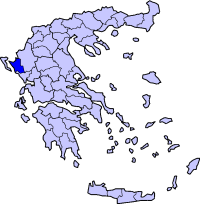
Administrative Region : Epirus
Regional unit : Thesprotia
 |
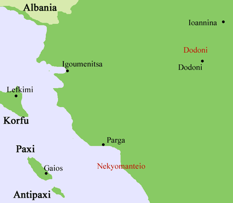 |
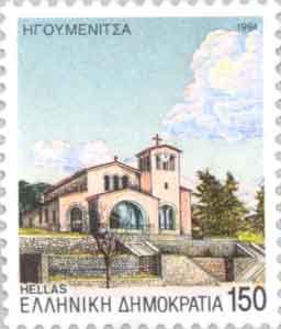
Igoumenitsa (Greek: Ηγουμενίτσα), is a coastal city in northwestern Greece. It is the capital of the peripheral unit Thesprotia. Its original ancient name used to be Titani.
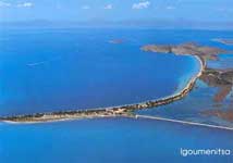
Igoumenitsa is a picturesque small town with lots of green (the dominating forest can be easily seen in the picture), beaches with crystal clear blue waters, and green mountains surrounding the town. The new 670 km Egnatia Highway, which serves northern Greece, terminates at Igoumenitsa.
Municipality
The present municipality Igoumenitsa was formed at the 2011 local government reform by the merger of the following 5 former municipalities, that became municipal units (constituent communities in brackets):[1]
Igoumenitsa (Agia Marina, Agios Vlasios, Graikochori, Igoumenitsa, Kastri, Kryovrysi, Ladochori, Mavroudi, Nea Selefkeia)
Margariti (Eleftheri, Karteri, Katavothra, Margariti, Mazarakia, Mesovouni, Spatharaioi)
Parapotamos (Drimitsa, Geroplatanos, Koritiani, Parapotamos)
Perdika
Syvota (Argyrotopos, Faskomilia, Plataria, Syvota)
History
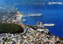
The port of the city.
In ancient times Igoumenitsa was known as Titani, (Gitani, Gitana, Goumani) and was one of the most important towns of the Kingdom of Thesprotis during the 4th century BC, covering 28 hectares. The circumference of its walls was 2,400 metres. The walls had four gates. Internal walls, in the shape of a sickle, divided the city in half. Its most noteworthy tower, located at the top of the hill, was round, and is thought to have been a religious sanctuary. Excavations have revealed a theatre which seats 2,500 and ruins of two temples.
The city was a meeting place of the Epirote League (Livy 42.38.1). A spur near Philiates between the Kalamas River, the acropolis had a fine semicircular tower. A small theater, towers, and gateways which are still visible. The Kalamas may have been navigable to this point. The city was destroyed by the Romans in 167 BC and later on it was annexed into the Roman Empire. It was ruled by Ottoman Empire and was renamed as "Reşadiye" in 1909 honour of Mehmet V, Ottoman Sultan between 1909 and 1918. During Italo-Turkish War, Hamidiye torpedo boat was sunk by an Italian destroyer on December 30, 1912[2] in here.
After the liberation of the region from ottoman rule during the balkan wars in 1913, the city name was Grava (greek: Γράβα) which means "cave" in ancient greek and in 1938 became head of the prefecture of Thesprotia and renamed to Igoumenitsa.
During World War II Igoumenitsa (Albanian: Gumenica) was burned by Cham Albanian collaborationist bands.[3]
Traffic
|
Superfast Ferries, Igoumenitsa |
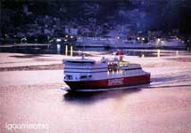
The Patras, Greece to Brindisi, Italy car–ferry ships of the Hellenic Mediterranean Lines (HML) stop at Igoumenitsa, before crossing the Adriatic Sea and vice versa, as well as the ships of Superfast Ferries, Anek Lines and several other shipping companies, before going to Ancona, Bari or Venice in Italy, and vice versa. Frequent passenger and car ferries to and from Corfu.
The Egnatia Odos motorway, which was opened in 2009 and is part of the Tabliczka E90.svg, has significantly enhanced the connection with Thessaloniki and Turkey and shortened the required travelling time from and to the Turkish border by several hours. Between Thessaloniki and the Turkish border, the road runs more or less parallel to the ancient Roman Via Egnatia.
Historical population
Year Town population Municipality population
1981 6,389 -
1991 6,807 11,608
2001 9,104 14,710
Climate
The average rainfall in Igoumenitsa is around 1,100 mm. By comparison in Athens it is only 380 mm; in Crete it is 640 mm, and in Ioannina 1,300 mm.
The temperature table are dated as of 2005.
Month Inland
temperature Sea
temperature
January 12°C 16°C
February 9°C 15°C
March 14°C 16°C
April 16°C 17°C
May 22°C 19°C
June 25°C 22°C
July 28°C 24°C
August 27°C 25°C
September 25°C 24°C
October 20°C 23°C
November 18°C 20°C
December 13°C 17°C
The water is safe for swimming between the months of May to November, that's only half a year. In 2005, the town had 65 rainy days, the summer had 4 rainy days with 10 hours of mix of sun and clouds each day. The last 25 years, the lowest temperature was -9°C and the highest was 43°C.
See also
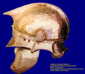
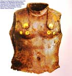
Silver War Helmet, Archaeological Museum of Igoumenitsa, Iron Thorax of Armour , Archaeological Museum of Igoumenitsa,
List of settlements in the Thesprotia prefecture
References
^ Kallikratis law Greece Ministry of Interior (Greek)
^ http://www.main-board.eu/guncel-sorunlar-ve-hayat/9383-1911-12-trablusgarp-savasinda-deniz-kuvvetleri.html
^ Antonina Zhelyazkova.Urgent Anthropology. Vol. 2. Albanian Prospects. IMIR, Sofia, 2003. p. 92
| Municipal unit Igoumenitsa |
|---|
|
Municipal Community Igoumenitsa
|
| Ethniki Antistasi (Εθνική Αντίσταση, η) |
| Igoumenitsa (Ηγουμενίτσα, η) |
| Lakka (Λάκκα, η) |
| Liofyta (Λιόφυτα, τα) |
| Pestaniotika (Πεστανιώτικα, τα) |
| Community Agia Marina |
| Agia Marina (Αγία Μαρίνα, η) |
| Vasilikos (Βασιλικός, ο) |
| Myloi (Μύλοι, οι) |
| Community Agios Vlasios |
| Agios Vlasios (Άγιος Βλάσιος, ο) |
| Community Graikochori |
| Graikochori (Γραικοχώρι, το) |
| Drosia (Δροσιά, η) |
| Filothei (Φιλοθέη, η) |
| Community Kastri |
| Kastri (Καστρίο, το) |
| Community Kryovrysi |
| Kryovrysi (Κρυόβρυση, η) |
| Community Ladochori |
| Ladochori (Λαδοχώρι, το) |
| Community Mavroudi |
| Mavroudi (Μαυρούδι, το) |
| Pigadi (Πηγάδι, το) |
| Community Nea Selevkeia |
| Ampelia (Αμπέλια, τα) |
| Nea Selevkeia (Νέα Σελεύκεια, η) |
| Ancient Greece
Science, Technology , Medicine , Warfare, , Biographies , Life , Cities/Places/Maps , Arts , Literature , Philosophy ,Olympics, Mythology , History , Images Medieval Greece / Byzantine Empire Science, Technology, Arts, , Warfare , Literature, Biographies, Icons, History Modern Greece Cities, Islands, Regions, Fauna/Flora ,Biographies , History , Warfare, Science/Technology, Literature, Music , Arts , Film/Actors , Sport , Fashion --- |
Retrieved from "http://en.wikipedia.org/"
All text is available under the terms of the GNU Free Documentation License
