

.
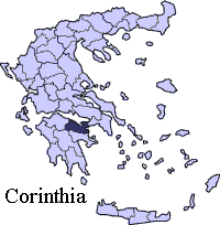
Prefectures : Arcadia , Argolis , Corinth, Laconia, Messinia
| Statistics | ||
|---|---|---|
| Periphery: | Peloponnese | |
| Capital: | Corinth | |
| Area: | 2,290 km ² | |
| Inhabitants: | 153,941 (2001) | |
| Pop. density: | 67.22 inh./km ² | |
| ISO 3166-2: | GR-15 | |
| Car designation | KP | |
| Code for the municipalities: | 30xx | |
| Number of municipalities | 15 | |
| Area codes in Greece: | 11+30-274x0 | |
| Name of inhabitants | Corinthian sing. Corinthians pl. |
|
| Postal code: | 20x xx | |
| Website: | Homepage of Corinthia | |
Corinthia (Greek: Κορινθία, Korinthía) is the area around the city of Corinth. Presently, it is a prefecture of Greece, part of the periphery of Peloponnese. It is the second-most populated prefecture on the Peloponnese peninsula.
The Corinth Canal, carrying ship traffic between the northern Mediterranean and the Aegean, is about 4 km east of Corinth, cutting through the Isthmus of Corinth. Agioi Theodoroi is the easternmost Corinthian community and is considered a suburb of Athens.
The area around Corinth and the western Saronic including the southeastern part are made up of fault lines including the Corinth Fault and the Poseidon Fault and includes one running from Perachora to Agioi Theodoroi. More faults are near Kria Vrysi and Sofiko.
Agriculture
The area is made up of many farmlands to the north and the west where it has olives, tomatoes, vegetables, pasture lands while the small mountains dominate the west, and some in the east and mountains dominate the south and northeast.
Its tallest mountain is Kyllini to its west.
History
From 1833 to 1899, it included Argolis and was known as Argolidocorinthia and included Hydra, Spetses and Kythira. Argolis joined Corinthia to re-form Argolidocorinthia again in 1909. Forty years later, in 1949, the prefecture was finally separated from Argolis, then Argolidocorinthia.
Climate
The climate of Corinthia has hot summers and mild winters. Most of the snow are founded in the mountains. In 2003, a torrential downpour devastated tens of cars on a local street and flooded properties.
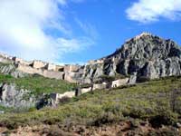
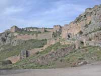
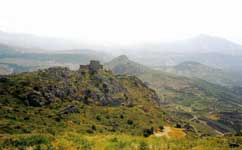
Acrocorinth, Click images to enlarge
Paus. 2.4.6
The Acrocorinthus is a mountain peak above the city, assigned to Helius by Briareos when he acted as adjudicator, and handed over, the Corinthians say, by Helius to Aphrodite. As you go up this Acrocorinthus you see two precincts of Isis, one if Isis surnamed Pelagian (Marine) and the other of Egyptian Isis, and two of Serapis, one of them being of Serapis called “in Canopus.” After these are altars to Helius, and a sanctuary of Necessity and Force, into which it is not customary to enter.
Above it are a temple of the Mother of the gods and a throne; the image and the throne are made of stone. The temple of the Fates and that of Demeter and the Maid have images that are not exposed to view. Here, too, is the temple of Hera Bunaea set up by Bunus the son of Hermes. It is for this reason that the goddess is called Bunaea.
Acrocorinth, 9km S of Corinth. Ancient Acropolis, Fortification by Byzantines, Francs, Venetians and Ottomans.
Transportation
The area is connected by highways:
E65, and with GR-8 to the boundary west of Derveni
Greece Interstate 7
Greece Interstate 8
Greece Interstate 8A/E94 from Corinth to the boundary.
Greece Interstate 66
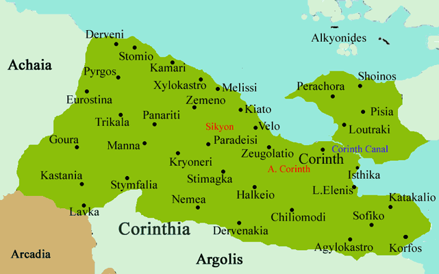
Municipalities
| Municipality | Municipal code | Seat | Postal code |
|---|---|---|---|
| Agioi Theodoroi | 3001 | Agioi Theodoroi | 200 03 |
| Assos-Lechaio | 3002 | Perigialo | 200 11 |
| Corinth | 3006 | Corinth | 201 00 |
| Evrostini | 3005 | Derveni | 200 09 |
| Feneos | 3015 | Goura | 200 14 |
| Loutraki-Perachoras | 3007 | Loutraki | 203 00 |
| Nemea | 3008 | Nemea | 205 00 |
| Saronikos | 3010 | Athikia | 200 05 |
| Sikyonies | 3011 | Kiato | 202 00 |
| Solygia | 3012 | Sofiko | 200 04 |
| Stymfalia | 3013 | Kaliani | 200 16 |
| Tenea | 3014 | Chiliomodi | 200 08 |
| Velo | 3003 | Velo | 200 02 |
| Vocha | 3004 | Zefgolatio | 200 01 |
| Xylokastro | 3009 | Xylokastro | 204 00 |
Places
Agioi Theodoroi
Corinth
Derveni
Kiato
Loutraki
Nemea
Stymfalia
Xylokastro
Greece :
A - B - C - D - E - F - G - H - I - J - K - L - M -
N - O - P - Q - R - S - T - U - V - W - X - Y - Z
| Ancient Greece
Science, Technology , Medicine , Warfare, , Biographies , Life , Cities/Places/Maps , Arts , Literature , Philosophy ,Olympics, Mythology , History , Images Medieval Greece / Byzantine Empire Science, Technology, Arts, , Warfare , Literature, Biographies, Icons, History Modern Greece Cities, Islands, Regions, Fauna/Flora ,Biographies , History , Warfare, Science/Technology, Literature, Music , Arts , Film/Actors , Sport , Fashion --- |
Retrieved from "http://en.wikipedia.org/"
All text is available under the terms of the GNU Free Documentation License
