
.
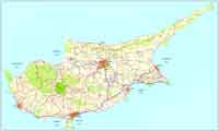
The B6 main road (locally referred as Limassol - Paphos old road, Greek "Παλαιός δρόμος Λεμεσού - Πάφου") used to be the main connecting route between Cyprus's second largest city, Limassol, and Paphos the island's top tourist destination.
History
Since the island's capital was moved from to Nicosia after the Roman times, Paphos used to be a very small town, transportation from the rest of the island was very difficult due to the mountainous geomorphology of the island's Southwestern coast. Until the British colonial times people also used the sea as an alternative to avoid the extremely long dangerous path connecting the two areas. In the early 20th Century the first road was built. It was approximately 80km long and not more than 3m wide. The B6 runs along the same corridor of the first road. After the Turkish invasion in 1974, and the occupation of the touristic key city of Famagusta the government searched for alternatives to attract tourism to the rest of the island. The need of good road transportation to the whole island was one of the first projects to be done. The road is 60km long (6km shorter than the A6 Motorway, a modern 4 lane highway that replaced the B6 as the main connecting route). It runs through 7 villages and the Western Sovereign Base Area.
Current Status
After the completion of the A6 Motorway in 2004 the road is only used by locals, and rarely big traffic volumes occur. It is a very well maintained road and a very interesting drive. A small part of it after the village Pissouri is used by tourists as scenic route, having a bend right next to Petra Tou Romiou, the legendary Aphrodite's birthplace.
| Ancient Greece
Science, Technology , Medicine , Warfare, , Biographies , Life , Cities/Places/Maps , Arts , Literature , Philosophy ,Olympics, Mythology , History , Images Medieval Greece / Byzantine Empire Science, Technology, Arts, , Warfare , Literature, Biographies, Icons, History Modern Greece Cities, Islands, Regions, Fauna/Flora ,Biographies , History , Warfare, Science/Technology, Literature, Music , Arts , Film/Actors , Sport , Fashion --- |