
.
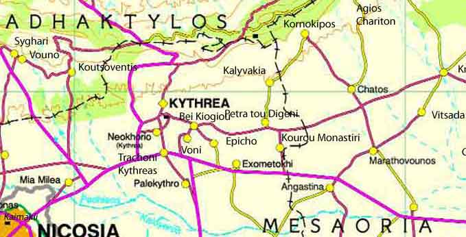
Agkastina or Angastina (Greek : Αγκαστίνα) is a community of the District of Famagusta in the occupied region of Cyprus. located around 20 km east of Nicosia, on the main road to Famagusta. It is perched on a steep limestone escarpment over the Pedias river plain at 66 metres above sea level.
| Year | Population |
| 1946 |
805 |
| 1960 |
778 |
| 1982 | |
| 1992 | |
| 2001 |
It is suggested by Nearchos Clerides, in Villages and Cities of Cyprus, that Angastina had been named from the Frank word gastina for crust. This alludes to the thick rocky shell rock (kafkala-Greek Cypriot for crust) that covered the surrounding mesas and on which the last version of the village was built. He suggests that name was modified by the locals and made their own by adding the A. [1] This is a likely possibility as the nearby village of Mora was “entirely a Frankish town under Frankish occupation. It was owned by the House of Moravit and it was named Mora for short. Cyprus at that time was ruled by the French House of Lusignan.” The Franks arrived in Cyprus “in the high and late Middle Ages, between 1192 and 1489. However George Jeffrey speculates that the name (on ancient maps “Angestrina ") may be from “neo-latin origin (1500-1900)”. [2] Christos Diakos in Angastina - History and Traditions agrees, pointing out that the “The church of Agios Therapon existed at our village since Byzantine time.
The name of the village was Agios Therapon. The name Angastina appears at the time of the Latin Venetians.” [3] It should be noted that the main church of Angastina up to 1974 was Agia Paraskevi, which has since been converted into a mosque.
Whatever is the case, Angastina is renowned for its long history which goes back to prehistoric times. Until 1950 it was on the rail line that connected Famagusta and Nicosia but now on that same carriageway is built a modern motorway. [4]
However Angastina was not always perched over the plains. There are still remnants of an older location of the village, to the south east towards Assia, which are still called Halospita (Ruined Houses). It is thought that either the devastation of The Plague in the 1430s or flooding from the Pedias River forced the original inhabitants to relocate the village to its present location: Latitude 35.204 and Longitude 33.583, about 70 metres above sea level.
Prehistoric Jug, on display at the Cyprus Museum, Nicosia,. It was dug up at Vouno, Angastina, Cyprus in 1962. Drawing by C. Moisa,2012.
Angastina is renowned for its Cypro-Mycenaean (10,000-800 BC) archaeological burial site of Vouno which was excavated 2 km east of the village in the 1962 when the new road to Famagusta was put through. According to Georgious Kyriakos in Cyprus Heritage, at the Cyprus Museum there are artifacts found in Vouno, such as “A Composite vase of White Painted V ware. It consists of four spherical parts joined to a common neck with a pinched mouth. A female figurine is attached to the neck; her right hand holding her breast and the left her abdomen.” This dates from the Middle Cypriot III period (1725–1625 BC).
During the Crusades, the village or near it was a fort for the cavalry of the Knight Templars (1291) and locations still bear within living memory such names as The Stables of the Kavalirides (the stables of the cavalry) or The Kavalarides.[5] [6] Since the Turkish invasion in 1974, the village has been inhabited by Turkish Cypriots and Turkish mainland settlers.[7] Turkish settlements are illegal under the municipal law of Cyprus.[8] Judge Loukēs G. Loukaidēs claims that such settlements are also illegal under international law and the Permanent Court of International Justice stated that repartition of Turkish settlers must take place to eliminate consequences of the "illegal act" of settlement.[8]
Agriculture
Angastina is famous for its vineyards and until World War II cotton was grown extensively in the area.[9] Wheat,barley and lentils were the main cereals grown before the 1974 Turkish invasion.
Famous Angastioniotes:
Angastina has produced several renowned artists, poets and entrepreneurs. The monk brothers Chariton (1887-1973), Stephanos (1894-1974) and Barnabas (1897-1974) who chose the monastery Apostle Barnabas, in Enkomi, as their presbytery were famous for their icons. Some they painted to decorate the ancient church and others they sold to buy materials and other provisions. “The most popular saints they paint(ed) are the Apostle Andrew, Blessed Virgin Mary, and Saint George.” [10]
The three monk brothers of Apostolos Varnavas: Charita (1887-1973), Stephanos (1894-1974) and Barnabas (1897-1974)
The primitive sculptor Kostas Nicoli Papa, who was recognised for his work in an exhibition in Ashia in 1946 was born there. 34 The writer and poet Kostas Pousis, educationalist expatriated artist Grigoris Kikillos, the naïve artist Nicos Nicolaides (1884-1956), politician and poet Andreas Kokoumas (1947- )(Antis) were also born in Angastina as was the well known business entrepreneur Photos Photiades. In 1997, Christos G. Diakos published a history of the village named Angastina-History and Tradition.
Churches
Agia Paraskevi - Greek Orthodox church - converted into a mosque by the Turkish settlers after Turkish invasion in August 1974.It was built in 1878 on an older church of the same name. The building 9of the Church was supervised by Master-mason Giakoumis Psoris.[11] In 1920 a lightning strike fell the bell tower and between 1957 an 58 a new bell tower was erected. See photograph to the right taken in 2012 that verifies its current status as a Mosque. Note the absence of a cross on the bell tower and the presence of a megaphone that is used by the Imam yo call his Moslem faithful to prayer.
Agios Therapon - Greek Orthodox church and cemetery.
References
^ Clerides, Nearchos (1961). Villages and Cities of Cyprus.
^ Jeffrey, George (1918). A description of the historic monuments of Cyprus.
^ Diakos, Christos (1997). Angastina-History and Tradition.
^ Flourentos, Pavlos (1996). Cyprus Heritage.
^ "Angastina-The Village of the Lotus Eaters". http://www.wix.com.
^ Clirides, Nearchou (1961). Villages and Cities of Cyprus.
^ Cyprus. Grapheion Dēmosiōn Plērophoriōn (1979). Colonisation of occupied areas. Public Information Office. p. 3. Retrieved 7 March 2011.
^ a b Loukēs G. Loukaidēs (29 May 1995). "5". Essays on the developing law of human rights. Martinus Nijhoff Publishers. pp. 108–135. ISBN 978-0-7923-3276-3. Retrieved 14 July 2011.
^ General History of Cyprus, Published 185, Alexandria.
^ Keshishian, Kevork.K. Romantic Cyprus, 11th edition,Pages 161-162. 1963.
^ Diakos, Christos-
Churches: Agia Paraskevi, Agios Therapon
Images Cyprus, Famagusta District
| Ancient Greece
Science, Technology , Medicine , Warfare, , Biographies , Life , Cities/Places/Maps , Arts , Literature , Philosophy ,Olympics, Mythology , History , Images Medieval Greece / Byzantine Empire Science, Technology, Arts, , Warfare , Literature, Biographies, Icons, History Modern Greece Cities, Islands, Regions, Fauna/Flora ,Biographies , History , Warfare, Science/Technology, Literature, Music , Arts , Film/Actors , Sport , Fashion --- |
Retrieved from "http://en.wikipedia.org/"
All text is available under the terms of the GNU Free Documentation License
